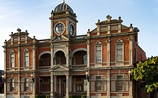
Castlemaine is a town in west central Victoria, Australia, in the Goldfields region about 120 kilometres northwest by road from Melbourne and about 40 kilometres from the major provincial centre of Bendigo. It is the administrative and economic centre of the Shire of Mount Alexander. The population at the 2021 Census was 7,506. Castlemaine was named by the chief goldfield commissioner, Captain W. Wright, in honour of his Irish uncle, Viscount Castlemaine.

Bulla is a locality and township in Melbourne, Victoria, Australia, 23 kilometres (14 mi) north-west of Melbourne's Central Business District, located within the City of Hume local government area. Bulla recorded a population of 668 at the 2021 census.

Kilmore is a town in the Australian state of Victoria. Located 65 kilometres (40 mi) north of Melbourne, it is the oldest inland town in Victoria by the combination of age and physical occupation, and because it had unique agricultural attributes to drive that earliest settlement. It grew very rapidly to become four times bigger than its nearest inland rival by 1851. Its spectacular growth continued to match that of the major gold mining towns of Ballarat, Bendigo and Beechworth until at least 1861.
Mount Duneed is a suburb of Geelong, Victoria, Australia. It is divided between the City of Greater Geelong and Surf Coast Shire local government areas. Mount Duneed itself is an extinct volcano and the remains of the crater can be seen in the Mount Duneed Recreation Reserve.

Trentham is a town in the Shire of Hepburn and Shire of Moorabool local government area of West Central Victoria, Australia. At the 2016 census, Trentham had a population of 1,180, with a median age of 55 years. Located at an altitude of 700 metres (2,297 ft), the town is 87 kilometres (54 mi) north-west of Melbourne. The Trentham area is located on the traditional lands of the Dja Dja Wurrung Aboriginal people.
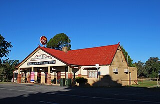
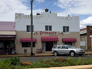
Amphitheatre is a town in Victoria, Australia. It is located on the Pyrenees Highway in the Pyrenees Shire, south-west of Avoca. At the 2021 census, Amphitheatre and the surrounding area had a population of 223.
Antwerp is a locality in Victoria, Australia on the Dimboola – Rainbow Road, in the Shire of Hindmarsh, 14 kilometres (8.7 mi) north of Dimboola and 356 kilometres (221 mi) north-west of Melbourne. The Wimmera River passes 500 metres (550 yd) west of the locality. The population at the 2016 census was 63.

Undera is a town in the Goulburn Valley region of northern Victoria, Australia. The town in the City of Greater Shepparton local government area, 211 kilometres (131 mi) north of the state capital, Melbourne and 26 kilometres (16 mi) north-west of the regional centre of Shepparton. At the 2011 census, Undera and the surrounding area had a population of 545, declining to just 442 by 2016.

Rosedale is a pastoral and agricultural town 184 kilometres east of Melbourne via the Princes Highway. It is situated on the southern side of the LaTrobe River. Once a staging post on the Port Albert to Sale and Port Albert to Walhalla coach runs, it was the administrative centre of the Shire of Rosedale which extended to the east and included the Ninety Mile Beach. It is now part of the Wellington Shire centred in Sale. At the 2006 census, Rosedale had a population of 1,077. The town is in the area of Gippsland explored separately by the Scotsman, Angus McMillan, and the Polish aristocrat, Count Paul von Strzelecki, in 1840. A memorial to McMillan is located in Rosedale, and one to Strzelecki near Traralgon to the west. Strzelecki named the region Gippsland after Governor Gipps.

Sutton Grange is a locality located approximately 30 kilometres (19 mi) south of Bendigo in Victoria, Australia.
Beaconsfield Upper is a town in Victoria, Australia, 45 km south-east of Melbourne's Central Business District, located within the Shire of Cardinia local government area. Beaconsfield Upper recorded a population of 2,997 at the 2021 census.
Malmsbury is a town in central Victoria, Australia on the Old Calder Highway (C794), 95 km north-west of the state capital, Melbourne and 11 km north-west of Kyneton. Situated close by the Coliban River, Malmsbury has a population of 1,101. Malmsbury is in the north western area of the Shire of Macedon Ranges local government area.

Newlyn is a town in the Shire of Hepburn, in Victoria, Australia. It is situated on the Midland Highway between Creswick and Daylesford. At the 2021 census, Newlyn had a population of 136.
Baradine is a small town in north western New South Wales, Australia. At the 2021 census, Baradine had a population of 593.

Campbells Creek is a town in Victoria, Australia.

Glenlyon is a small village in the Shire of Hepburn local government area, Victoria, Australia around 10 km from Daylesford along the Daylesford–Malmsbury Road, and around 101 km from the Melbourne CBD via Kyneton and Malmsbury.

Shelford is a rural locality in Victoria, Australia. The locality is in the Golden Plains Shire near the regional city of Geelong and 106 kilometres (66 mi) west of the state capital, Melbourne.

Franklinford is a locality in the Central Highlands of Victoria, Australia, located in the Shire of Hepburn.

Snake Valley is a town in central Western Victoria, Australia, on Linton-Carngham Road, 27 kilometres (17 mi) west of Ballarat and 153 kilometres (95 mi) west of Melbourne, in the Shire of Pyrenees. A post office was opened on 1 March 1859. At the 2016 Census, Snake Valley had a population of 743, up from 329 in 2006.
Crowlands is a locality nestled on the Wimmera River and is located approximately 24 kilometres (15 mi) northeast of the town of Ararat, in the state of Victoria, Australia. It comprises a small village area of scattered houses and larger farms.

