Underground hard-rock mining refers to various underground mining techniques used to excavate "hard" minerals, usually those containing metals, such as ore containing gold, silver, iron, copper, zinc, nickel, tin, and lead. It also involves the same techniques used to excavate ores of gems, such as diamonds and rubies. Soft-rock mining refers to the excavation of softer minerals, such as salt, coal, and oil sands.

A submersible pump (or electric submersible pump is a device which has a hermetically sealed motor close-coupled to the pump body. The whole assembly is submerged in the fluid to be pumped. The main advantage of this type of pump is that it prevents pump cavitation, a problem associated with a high elevation difference between the pump and the fluid surface. Submersible pumps push fluid to the surface, rather than jet pumps, which create a vacuum and rely upon atmospheric pressure. Submersibles use pressurized fluid from the surface to drive a hydraulic motor downhole, rather than an electric motor, and are used in heavy oil applications with heated water as the motive fluid.
An adit or stulm is a horizontal or nearly horizontal passage to an underground mine. Miners can use adits for access, drainage, ventilation, and extracting minerals at the lowest convenient level. Adits are also used to explore for mineral veins. Although most strongly associated with mining, the term adit is sometimes also used in the context of underground excavation for non-mining purposes; for example, to refer to smaller underground passageways excavated for underground metro systems, to provide pedestrian access to stations, and for access required during construction.

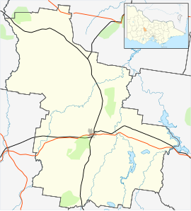
Kingston is a small town and locality of 19.07km2 in the rural Shire of Hepburn in Victoria, Australia, located just off the Midland Highway about 10 kilometres distance from Creswick, and is about 20 km from Daylesford. Kingston's post code is 3364.

Corowa is a town in the state of New South Wales in Australia. It is on the bank of the Murray River, the border between New South Wales and Victoria, opposite the Victorian town of Wahgunyah. It is the largest town in the Federation Council and was the administrative centre of the former Corowa Shire. The name could have derived from an Aboriginal word referring to the curra pine which yielded gum used by Aboriginal people to fasten the heads of spears to the shafts. Another translation is "rocky river".

The Homestake Mine was a deep underground gold mine located in Lead, South Dakota. Until it closed in 2002 it was the largest and deepest gold mine in the Western Hemisphere. The mine produced more than forty million troy ounces of gold during its lifetime. This is about 2,500 cubic feet (71 m3) or a volume of gold roughly equal to 18,677 US gallons.

Mine exploration is a hobby in which people visit abandoned mines, quarries, and sometimes operational mines. Enthusiasts usually engage in such activities for the purpose of exploration and documentation, sometimes through the use of surveying and photography. In this respect, mine exploration might be considered a type of amateur industrial archaeology. In many ways, however, it is closer to caving, with many participants actively interested in exploring both mines and caves. Mine exploration typically requires equipment such as helmets, head lamps, Wellington boots, and climbing gear.
Elandsrand is a small mining town approximately 10 km (6 mi) outside Carletonville next to Blyvooruitzicht.

Quartz reef mining is a type of gold mining in "reefs" (veins) of quartz. Quartz is one of the most common minerals in the Earth's crust, and most quartz veins do not carry gold, but those that have gold are avidly hunted by prospectors. In the shallow, oxidized zones of quartz reef deposits, the gold occurs in its metallic state, and is easily recovered with simple equipment. Quartz reef mining played an important role in 19th century gold-mining districts such as Bendigo, Victoria in Australia, Central Otago in New Zealand, and the California mother lode.

Pleasley Colliery is a former English coal mine. It is located to the north-west of Pleasley village, which sits above the north bank of the River Meden on the Nottinghamshire/Derbyshire border. It lies 3 miles (4.8 km) north of Mansfield and 9 miles (14.5 km) south of Chesterfield. From the south it commands a prominent position on the skyline, although less so now than when the winders were in operation and both chimney stacks were in place. The colliery is situated at about 500 ft (152m) above sea level and is aligned on a NE–SW axis following the trend of the river valley at this point.

Chatterley Whitfield Colliery is a disused coal mine on the outskirts of Chell, Staffordshire in Stoke on Trent, England. It was the largest mine working the North Staffordshire Coalfield and was the first colliery in the UK to produce one million tons of saleable coal in a year.
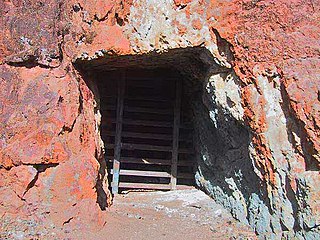
The New Australasian No.2 Deep Lead Gold Mine, was a goldmine located in Creswick, Victoria, Australia, that is now infamous for being Australia's worst below-ground gold mining disaster.

Mount Franklin is an extinct volcano about 10 km north of Daylesford and 4.6 km south east of Franklinford in Victoria, Australia. A road spirals round the outside slopes covered with pine trees, into a flat 50 acre caldera, and onto the rim which hosts a fire lookout, parking area and picnic ground.

Several underground explosive charges were fired during the First World War at the start of the Battle of Messines (7–14 June 1917). The battle was fought by the British Second Army and the German 4th Army near Mesen in Belgian West Flanders. The mines, secretly planted and maintained by tunnelling companies of the Royal Engineers beneath the German front position, killed many German soldiers and created 19 large craters.
Einasleigh Copper Mine and Smelter is a heritage-listed mine at Daintree Road, Einasleigh, Shire of Etheridge, Queensland, Australia. It was built from 1867 to 1922. It is also known as Lynd Copper Mine and New Einasleigh Copper Mine. It was added to the Queensland Heritage Register on 11 December 2006.

Golden Gate Mining and Town Complex is a heritage-listed mining camp at Normanton Road, Croydon, Shire of Croydon, Queensland, Australia. It commenced in 1886. It is also known as Golden Gate Township, Croydon Consols Pump Shaft, Golden Gate No.10 North Mine, Golden Gate Cemetery, Croydon Consols Battery and Cyanide Plant, and Golden Gate Mine. It was added to the Queensland Heritage Register on 14 August 2009.

Basset Mines was a mining company formed in Cornwall, England, by the amalgamation of six copper and tin mining setts. It operated from 1896 until 1918, when it was closed due to a fall in the price of tin.

The Great Laxey Mine was a silver, lead ore and zinc mine located in Laxey, in the parish of Lonan, Isle of Man. The mine reached a depth in excess of 2,200 ft (670 m) and consisted primarily of three shafts: the Welsh Shaft, the Dumbell's Shaft and the Engine Shaft; each of these shafts was connected by a series of levels.
Deep Lead Nature Conservation Reserve is a protected area in the Australian state of Victoria located in the state's west on the north side of the town centre in Stawell. The area was formerly used for gold mining but now contains a variety of Eucalyptus which provide habitat for a range of birds and mammals, including some endangered species. Several species of rare ground orchids also grow in the reserve.
Hapton Valley Colliery was a coal mine on the edge of Hapton near Burnley in Lancashire, England. Its first shafts were sunk in the early 1850s and it had a life of almost 130 years, surviving to be the last deep mine operating on the Burnley Coalfield.