
Venustiano Carranza is one of the 16 boroughs of Mexico City. The borough was formed in 1970 when the center of Mexico City was subdivided into four boroughs. Venustiano Carranza extends from the far eastern portion of the historic center of Mexico City eastward to the Peñón de los Baños and the border dividing the then Federal District from the State of Mexico. Historically, most of the territory was under Lake Texcoco, but over the colonial period into the 20th century, the lake dried up and today the area is completely urbanized. The borough is home to three of Mexico City's major traditional markets, including La Merced, the National Archives of Mexico, the Palacio Legislativo de San Lázaro, the TAPO intercity bus terminal and the Mexico City Airport.

Sevilla is a station on Line 1 the Mexico City Metro. It is located in the Cuauhtémoc borough in the centre of Mexico City, on Avenida Chapultepec and Sevilla street. It serves colonias Roma and Juárez.

Metro Balderas is an underground station on the Mexico City Metro. It is located in the Cuauhtémoc borough in the center of Mexico City. It is a transfer station along Lines 1 and 3.

Metro Santa Anita is a station on the Mexico City Metro. Located in Mexico City's Iztacalco borough, the station is the current terminal of Line 4.
Metro Hidalgo is a station on Line 2 and Line 3 of the Mexico City Metro system. It is located in the Cuauhtémoc borough of Mexico City, west of the city centre, on Hidalgo Avenue and serves the Colonia Tabacalera, Colonia Guerrero, and Colonia Centro districts.

Metro Candelaria is a Mexico City Metro rail station. It is located in Venustiano Carranza borough east of downtown Mexico City. It lies along Lines 1 and 4.

Talismán is a station along Line 4 of the Mexico City Metro, located in Gustavo A. Madero borough.
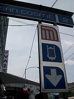
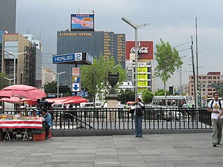
San Cosme is a station on Line 2 of the Mexico City Metro system. It is located in the Cuauhtémoc municipality of Mexico City, northwest of the city centre, on Avenue Ribera de San Cosme a few blocks before it becomes Calzada México-Tacuba. The southern exit leads to Colonia San Rafael while the Northern one leads to Colonia Santa María la Ribera. It is two blocks from the Mercado de San Cosme. In 2019, the station had an average ridership of 22,892 passengers per day.

Metro Chabacano is a station on Lines 2, 8 and 9 of the Mexico City Metro system. It is located in the Cuauhtémoc borough of Mexico City, south of the city centre, on Calzada de Tlalpan.

Metro Niños Héroes / Poder Judicial CDMX is a metro station along Line 3 of the Mexico City Metro. It is located in the Cuauhtémoc borough of Mexico City.

Metro Bondojito is a metro station along Line 4 of the Mexico City Metro. It is located in the Gustavo A. Madero borough of Mexico City.

Metro Consulado is a station on the Mexico City Metro. It is located between Gustavo A. Madero and Venustiano Carranza boroughs, in the north of Mexico City.

Metro Canal del Norte is a station on the Mexico City Metro. It is located in the Venustiano Carranza borough, in the north of Mexico City.

Metro Fray Servando is a metro station along Line 4 of the Mexico City Metro. It is located in the Venustiano Carranza borough of Mexico City.
Mexico City Metro Line 4 is the fourth line of Mexico City Metro. The line color is aqua blue and it runs from north to south of the city crossing the city center by its easternmost area. In 2019 it had a total ridership of 29,013,032 passengers, making it the least used line on the system.

Colonia Obrera is an administrative neighborhood of the borough of Cuauhtémoc in the center of Mexico City. It was established in the late 19th and early 20th centuries and became home to many artisans and industrial workmen. Up to the early 1980s, a number of sewing factories were still located here, but the 1985 Mexico City earthquake destroyed many, including the Topeka factory in which many of the seamstresses died inside. Today, the area has a high crime rate but there have been efforts to revitalize it.
Colonia Santa María Insurgentes is a colonia in the Cuauhtémoc borough north east of the Mexico City’s historic center. The colonia’s borders are formed by the following roads: Calzada de San Simon to the south, Jacarandas to the north, Avenida de los Insurgentes Norte to the east and Jacarandas to the west.

Mercado Jamaica is one of Mexico City’s traditional public markets where various vendors sell their wares in an established location. This market begat in the 1950s as part of efforts to urbanize the markets in the area. The market is located on the corner of Congreso de la Union and Avenida Morelos, just southeast of the historic center of the city. Although it is one of the main markets for souvenirs, produce and meat, it is best known for its flowers and ornamental plants. There are 1,150 stands dedicated to the selling of cut flowers, flower arrangements, ornamental plants and accessories such as flowerpots. The market offers about 5,000 types of flowers and plants, mostly foreign, but there is a number of native Mexican species available, including some gathered directly from the wild.
Metro Insurgentes Sur is a station on Line 12 of the Mexico City Metro. The station is located between Mixcoac and Hospital 20 de Noviembre. It was opened on 30 October 2012 as part of the first stretch of Line 12 between Mixcoac and Tláhuac. It is built underground.
The Cuernavaca Municipality is one of 36 municipalities in the State of Morelos, Mexico. Located in the northwest of the state, it consists of the City of Cuernavaca, which is the state and municipal capital, as well as other, smaller towns. The population is 366,321.


