| Meyers Lake | |
|---|---|
 Meyers Lake Location in Ontario | |
| Location | Cochrane District and Timiskaming District, Ontario |
| Coordinates | 48°16′21″N80°17′49″W / 48.27250°N 80.29694°W Coordinates: 48°16′21″N80°17′49″W / 48.27250°N 80.29694°W |
| Part of | James Bay drainage basin |
| Primary inflows | Benoit Creek, Sarsfield Creek, Woollings Creek |
| Primary outflows | Woollings Creek |
| Basin countries | Canada |
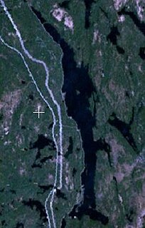
| Max. length | 1.91 km (1.19 mi) |
| Max. width | 1.77 km (1.10 mi) |
| Surface elevation | 313 metres (1,027 ft) [1] |
| Islands | 3 |
| References | [2] |
Meyers Lake is a lake in Cochrane District and Timiskaming District, in northeastern Ontario, Canada. [2] The lake is in the James Bay drainage basin and the nearest community is Bourkes, 4.6 kilometres (2.9 mi) to the northeast.

A lake is an area filled with water, localized in a basin, that is surrounded by land, apart from any river or other outlet that serves to feed or drain the lake. Lakes lie on land and are not part of the ocean, and therefore are distinct from lagoons, and are also larger and deeper than ponds, though there are no official or scientific definitions. Lakes can be contrasted with rivers or streams, which are usually flowing. Most lakes are fed and drained by rivers and streams.
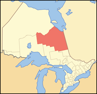
Cochrane District is a district and census division in Northeastern Ontario in the Canadian province of Ontario. It was created in 1921 from parts of Timiskaming and Thunder Bay districts.

Timiskaming is a district and census division in Northeastern Ontario in the Canadian province of Ontario. The district was created in 1912 from parts of Algoma, Nipissing, and Sudbury districts. In 1921, Cochrane District was created from parts of this district and parts of Thunder Bay District.
The northern quarter of the lake is in geographic Black Township [3] in the municipality of Black River-Matheson, Cochrane District; the rest of the lake is in geographic Lee Township [4] in the Unorganized West Part of Timiskaming District.

Black River-Matheson is a township in the Cochrane District of the Canadian province of Ontario. The municipality is astride the Black River, for which it is partly named. The Matheson railway station was serviced by the Northlander until 2012.
Lee Township is a geographic township in the Unorganized West Part of Timiskaming District in northeastern Ontario, Canada. The township is uninhabited, and has no communities.

Unorganized West Timiskaming District is an unorganized area in the Canadian province of Ontario, comprising almost all portions of the Timiskaming District which are not organized into incorporated municipalities.
The lake is about 1.91 kilometres (1.19 mi) long and 1.77 kilometres (1.10 mi) wide. It has three small, unnamed islands. The primary inflows are Sarsfield Creek at the west; Woollings Creek at northwest; and Benoit Creek at the northeast. There is one unnamed secondary inflow at the north. The primary outflow, at the east, is also Woollings Creek, which heads southeast to its mouth at Swan Lake. The latter lake empties via the Whiteclay River, the Black River, the Abitibi River and the Moose River to James Bay.

Sarsfield Creek is a creek in Timiskaming District in northeastern Ontario, Canada. It is in the James Bay drainage basin and is a right tributary of Woollings Creek.
Woollings Creek is a creek in Timiskaming District and Cochrane District in northeastern Ontario, Canada. It is in the James Bay drainage basin and is a tributary of the Whiteclay River.
Benoit Creek is a creek in Timiskaming District and Cochrane District in northeastern Ontario, Canada. It is in the James Bay drainage basin and is a left tributary of Woollings Creek.