
The location of the geographical centre of Europe depends on the definition of the borders of Europe, mainly whether remote islands are included to define the extreme points of Europe, and on the method of calculating the final result. Thus, several places claim to host this hypothetical centre.

The European route E 22 is one of the longest European routes. It has a length of about 5,320 km (3,310 mi). Many of the E-roads have been extended into Asia since the year 2000; the E 22 was extended on 24 June 2002.

Gibbs Stadium is a 13,000-seat multi-purpose stadium in Spartanburg, South Carolina. It opened in 1996 and is home to the Wofford College Terriers football team. It is also the home to the Spartanburg High School varsity football team. It is home to the 30th largest college football scoreboard in the nation at 1,485 square feet (138.0 m2). It was named for the Gibbs family, long-time donors to Wofford, for their 1 million dollar donation to build it.
Goldpan Provincial Park is a provincial park in British Columbia, Canada, located on the Trans-Canada Highway between Lytton (W) and Spences Bridge (E), on the Thompson River. The park has camping above the highway and a picnic area and riverfront below.
Shuswap Lake Marine Provincial Park is an 896-hectare provincial park in British Columbia, Canada, comprising 991 ha. The Park has a variety of amenities including boat launch ramps, picnic areas, and 27 campsites around the perimeter of Shuswap Lake. The lake's name and that of the surrounding Shuswap Country is from the Shuswap people (Secwepemc), the most northern of the Salishan speaking people.

Pozières is a commune in the Somme department in Hauts-de-France in northern France.

Beszterec is a village in Szabolcs-Szatmár-Bereg county, in the Northern Great Plain region of eastern Hungary.
Nyírtura is a village in Szabolcs-Szatmár-Bereg county, in the Northern Great Plain region of eastern Hungary.

Advanced Landing Grounds (ALGs) were temporary advance airfields constructed by the Allies during World War II during the liberation of Europe. They were built in the UK prior to the invasion and thereafter in northwest Europe from 6 June 1944 to V-E Day, 7 May 1945.

The 250 or so "Narrow Bantu languages" are conventionally divided up into geographic zones first proposed by Malcolm Guthrie (1967–1971). These were assigned letters A–S and divided into decades ; individual languages were assigned unit numbers, and dialects further subdivided. This coding system has become the standard for identifying Bantu languages; it was the only practical way to distinguish many ambiguously named languages before the introduction of ISO 639-3 coding, and it continues to be widely used. Only Guthrie's Zone S is (sometimes) considered to be a genealogical group. Since Guthrie's time a Zone J has been set up as another possible genealogical group bordering the Great Lakes.
Phượng Sơn is a commune (xã) and village in Lục Ngạn District, Bắc Giang Province, in northeastern Vietnam.
Tân Mộc is a commune (xã) and village in Lục Ngạn District, Bắc Giang Province, in northeastern Vietnam.
Pácin is a village in Borsod-Abaúj-Zemplén County in northeastern Hungary.
Tiszatarján is a village in Borsod-Abaúj-Zemplén County in northeastern Hungary.
Saptamukhi River is a tidal estuarine river in and around the Sundarbans in South 24 Parganas district in the Indian state of West Bengal.

Bukova Glava is a village in the municipality of Leskovac, Serbia. According to the 2002 census, the village has a population of 295 people.
Koerakuiv is an island belonging to the country of Estonia.
Telve is an island belonging to the country of Estonia.
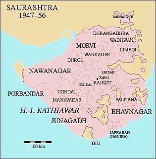
Palitana was a princely state in India during the British Raj until 1948. The center was the city of Palitana. The last ruler of the state received a privy purse of 180,000 Rupees at the state's accession to independent India on 15 February 1948.
Khonog is a village in Sorkheh Rural District, Fath Olmobin District, Shush County, Khuzestan Province, Iran. At the 2006 census, its existence was noted, but its population was not reported.


