Dinckley Brook is a minor river of Lancashire, England. The stream rises at the confluence of several minor watercourses at Wheatley Farm close to Copster Green and flows northwards, through Cunliffe House Wood and under Dinckley Bridge. The brook continues past Brockhall, Great Wood and Bradyll, continuing past the Brockhall training base of Blackburn Rovers and through Mill Wood. Soon afterwards, Dinckley Brook falls into the River Ribble.

Ľubiša is a village and municipality in Humenné District in the Prešov Region of north-east Slovakia.
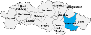
Pakostov is a village and municipality in Humenné District in the Prešov Region of north-east Slovakia.

Lipníky is a village and municipality in Prešov District in the Prešov Region of eastern Slovakia.

The St. Petersburg I. I. Mechnikov State Medical Academy (SPSMA) is a public university located in St. Petersburg, Russian Federation. The SPSMA is one of the oldest and largest Russian Higher Medical Schools. Over its 100 years of history, the Academy remains a leading institution of Russia in medicine and training specialists in preventive and clinical medicine. It is often called the Second Medical College in St. Petersburg because of its renaming in 1920, relative to Saint Petersburg State Medical University, which is called the First Medical College. The university is currently constructing the largest infectious diseases hospital in Saint Petersburg, a title formerly claimed by the Botkin hospital.
Podhorany is a small village and municipality in Prešov District in the Prešov Region of north Slovakia.

Budíkov is a village in the Pelhřimov District, Vysočina Region of the Czech Republic. About 283 people live there and it has 6,64 km². Budíkov was first documented in 1226.

Bukhta-Ilicha is a village in Baku, Azerbaijan.
Wygnańczyce is a village in the administrative district of Gmina Wschowa, within Wschowa County, Lubusz Voivodeship, in western Poland.
Choratice is a municipality and village in Benešov District in the Central Bohemian Region of the Czech Republic.

Hadnock Halt railway station is a disused railway station on the Ross and Monmouth Railway which was only open for eight years, 1951 to 1959, closing when passenger services were withdrawn from the line. The platform still exists and the trackbed is part of a cycleway.
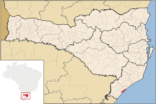
Balneário Arroio do Silva is a municipality in the state of Santa Catarina in the South region of Brazil.
Timbé do Sul is a municipality in the state of Santa Catarina in the South region of Brazil.

Vina is a village in the municipality of Leskovac, Serbia. According to the 2002 census, the village has a population of 232 people.
Ağılcık is a village in the District of Çubuk, Ankara Province, Turkey.
Saraycık, Çubuk is a village in the District of Çubuk, Ankara Province, Turkey.
Patinoire de Boulogne-Billancourt is an indoor arena located in Boulogne-Billancourt, France. It is the home arena of the AC Boulogne-Billancourt ice hockey team. The arena opened in 1955.

Głubczyce Town Hall - a Renaissance building in Głubczyce, Głubczyce County, Opole Voivodeship; in Poland. The first mention of a town hall in Głubczyce was in 1383, when a thirteenth-century townhouse was reconstructed into the town hall. The town hall's Renaissance architectural style structure and attic style was built in 1570. Reconstructions in the years of 1863-1864 and 1936, gave the building its Neo-Gothic architectural style. The town hall's decorative statues and towers were built in the nineteenth-century. The town hall was renovated in 2006, partly funded by the European Union.
Balakai Mesa is a summit in the U.S. state of Arizona.

Pistyll Cain, also written as Pistill Cain and Pistill Y Caen, is a renowned waterfall in Merionethshire, a county in north Wales. It lies north-east of Ganllwyd off the A470 trunk road between Dolgellau and Trawsfynydd.


