
North Holland is a province of the Netherlands in the northwestern part of the country. It is located on the North Sea, north of South Holland and Utrecht, and west of Friesland and Flevoland. In November 2019, it had a population of 2,877,909 and a total area of 4,092 km2 (1,580 sq mi), of which 1,430 km2 (550 sq mi) is water.

Cromstrijen was a municipality on the Hoeksche Waard Island in the western Netherlands, in the province of South Holland. The municipality covers an area of 70.33 km2 (27.15 sq mi) of which 15.96 km2 (6.16 sq mi) is water. It was formed on 1 January 1984, when the municipalities on the Hoeksche Waard were merged into larger municipalities. On 1 January 2019 it was merged with the municipalities of Binnenmaas, Korendijk, Oud-Beijerland, and Strijen to form the municipality of Hoeksche Waard.

Hollands Diep is a wide river in the Netherlands and an estuary of the Rhine and Meuse rivers. Through the Scheldt-Rhine Canal it connects to the Scheldt river and Antwerp.

The Hoekse Waard is an island between the Oude Maas, Dordtsche Kil, Hollands Diep, Haringvliet and Spui rivers in the province of South Holland in the Netherlands. The island, part of the namesake municipality of Hoeksche Waard, is a mostly agricultural region, south of the outskirts of Rotterdam. The Hoeksche Waard consists of reclaimed land (polders): after the Saint Elisabeth flood of 1421 most of the area was flooded. The land has been reclaimed gradually in the following centuries.

Ouddorp is a village in the Dutch province of South Holland. It is part of the municipality of Goeree-Overflakkee. It is often referred to as Ouddorp aan Zee to promote itself as a seaside resort, because the village has an 18 kilometres (11 mi) long beach which is the longest of the Netherlands.

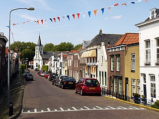
Numansdorp is a town and former municipality in the province South Holland in the Netherlands and is located on the island Hoeksche Waard near the Hollands Diep. On 1 January 1984, the municipalities Numansdorp and Klaaswaal were merged into one municipality called Cromstrijen. Cromstrijen was merged into the new municipality Hoeksche Waard in January 2019.

Den Bommel is a village in the Dutch province of South Holland. It is a part of the municipality of Goeree-Overflakkee, and lies about 14 km south of Spijkenisse.
Ooltgensplaat is a village in the Dutch province of South Holland. It is a part of the municipality of Goeree-Overflakkee, and lies about 17 km south of Spijkenisse.

Nieuwe-Tonge is a village in the Dutch province of South Holland. It is a part of the municipality of Goeree-Overflakkee, and lies about 13 km south of Hellevoetsluis.

Nieuw-Beijerland is a village in the Dutch province of South Holland. It is a part of the municipality of Hoeksche Waard, and lies about 3 km south of Spijkenisse.

Piershil is a village in the Dutch province of South Holland. It is a part of the municipality of Hoeksche Waard, and lies about 5 km south of Spijkenisse.

Goudswaard is a village in the Dutch province of South Holland, located on the westernmost tip of the Hoeksche Waard, approximately 6 km south-west of Spijkenisse. Goudswaard was a separate municipality from 1817 until 1984, when it was merged with Nieuw-Beijerland, Zuid-Beijerland and Piershil to form the municipality of Korendijk.

Zuid-Beijerland is a village in the Dutch province of South Holland. It is a part of the municipality of Hoeksche Waard, and lies about 10 km south of Spijkenisse.

Cillaarshoek is a hamlet in the western Netherlands. It is located in the municipality of Hoeksche Waard, South Holland, about 15 km south of Rotterdam.

Heinenoord is a village in the Dutch province of South Holland on the island Hoekse Waard. It is located about 10 km south of Rotterdam, in the municipality of Hoeksche Waard.

Klaaswaal is a village and former municipality in the Dutch province of South Holland. It is centrally located on one of the island Hoeksche Waard. Klaaswaal was a separate municipality until 1984, when it was merged with Numansdorp to form the municipality Cromstrijen.
Oudesluis is a hamlet in the Dutch province of South Holland and is part of the municipality of Hoeksche Waard.

Mijn Genoegen is a paltrok mill in the Netherlands Open Air Museum in Arnhem, Gelderland, Netherlands which has been restored to working order. As are all Dutch paltrok mills, it is a wind-powered sawmill.
Airfield Numansdorp(Dutch: vliegveld Numansdorp) is a private owned airfield just south of the hamlet Middelsluis in Numansdorp, South Holland. The airfield is used once a year by Rotterdam Football club Feyenoord to fly their new players to their stadium, nicknamed De Kuip, during their season opening event. It is also home to a paragliding-club and occasionally used for events, like agricultural shows.

Hoeksche Waard is a municipality in the western Netherlands, in the province of South Holland, consisting of the eponymous Hoeksche Waard and Tiengemeten islands.


