Puttershoek

Last updated

Puttershoek
Village
Puttershoekhaven.JPG
The 16th-century harbour of Puttershoek
Puttershoek vlag.svg
P08-ZH-positiekaart2-gemlabels.png
Red pog.svg
Puttershoek
Location in the province of South Holland in the Netherlands
Netherlands location map.svg
Red pog.svg
Puttershoek
Location in the Netherlands
Coordinates: 51°48′N4°34′E / 51.800°N 4.567°E / 51.800; 4.567 Coordinates: 51°48′N4°34′E / 51.800°N 4.567°E / 51.800; 4.567
Country Netherlands
Province South Holland
Municipality Hoeksche Waard
Area
[1]
  Total5.64 km2 (2.18 sq mi)
Elevation
[2]
0.4 m (1.3 ft)
Population
 (2021) [1]
  Total7,205
  Density1,300/km2 (3,300/sq mi)
Time zone UTC+1 (CET)
  Summer (DST) UTC+2 (CEST)
Postal code
3297 [1]
Dialing code 0186

Puttershoek is a village and former municipality in the western Netherlands. It is located on the banks of the Oude Maas, on the island Hoeksche Waard, in the province of South Holland. On 1 January 1984, the municipality of Puttershoek was merged with several others into Binnenmaas. With 6,293 inhabitants (1 January 2005) Puttershoek was the largest settlement in the municipality of Binnenmaas until 's-Gravendeel joined Binnenmaas in 2007. Since 1 January 2019, it is part of the new municipality Hoeksche Waard. [3]

Contents

History

Before the St. Elizabeth's flood (1421) a township named Hoecke was located on the spot of the present-day town. The name Hoecke (meaning Corner) is probably derived from the sharp angle the dike around the former Grote or Zuid-Hollandsche Waard island took here. After the St. Elizabeth's flood, the land was owned by the Lords of Putten, who loaned it to a vassal lord. The first four vassal lords of Hoecke were all named Pieter. It remains unclear if the name Puttershoek is taken from Pietershoeck, or if it is a reference to the Lords of Putten.

Until the 19th century, Puttershoek was a small and remote village, where reed cutting was the main source of income. However, in 1912 a large sugar beet processing plant was built in the village, bringing not only employment and a sweet odour during fall, but also employees from the Catholic North Brabant province. A thriving Catholic community was founded in the very Protestant village, building one of only two Catholic churches on the Hoeksche Waard island. During World War II, V-1 missiles were launched from the factory by the German occupying forces. The factory was bombed, and was rebuilt after the war. At the end of 2004, the sugar mill closed its doors. [4] Most of its buildings were demolished in 2012.

Puttershoek was partially flooded during the big North Sea flood of 1953. After the flood the dike along the Oude Maas was raised. For this, nearly half of the old town (the Weverseinde dike) was torn down between 1964 and 1966. [5] The monumental 17th-century farm Rustenburg burnt down in 1997 and was demolished. [6]

Architecture

Puttershoek retains several recognised architectural monuments, most of which are concentrated around the small river harbour on the Oude Maas and the Schouteneinde dike. The Protestant church was built in 1839, replacing a 15th-century church in the same location. Part of the church tower and the interior date back to the previous structure. The former town hall was built in 1835 in the neoclassicist style. The port is lined with 17th-century houses with characteristic gables. The old post office Het Springende Peerd, with stepped gable and gable stone, dates from 1648. There are several large 18th- and 19th-century farms along the Arent van Lierstraat. The windmill De Lelie, on the Molendijk towards 's-Gravendeel, was built in 1836 and renovated in 1986. In the lower part of town there are several wooden houses, donated by the Norwegian government after World War II. The old pumping station Het Hooft van Benthuizen was built in 1870 for drainage of the polder Nieuw-Bonaventura and the canal Boezemvliet. [5] It is due to be demolished, to make way for housing development. [7]

Famous residents

The most renowned inhabitant is Kees Verkerk who won many speed skating medals including a gold medal in the 1968 Winter Olympics. Presently, Verkerk lives in Norway, but his house still hosts the cafe and bar his father owned for many years, Het Veerhuis, found at the harbour-side.

Related Research Articles

IJsselmonde (island)

IJsselmonde is a river island in the Netherlands, between the Nieuwe Maas, Noord and Oude Maas branches rivers of the Rhine-Meuse delta in the province of South Holland. The city of Rotterdam now occupies most of the northern part of the island and includes the eponymous former village of IJsselmonde, once a separate community. The island was once a rich agricultural region, but is mostly suburbs today. Only the mid-south parts of the island have retained their agricultural character.

Binnenmaas Former municipality in South Holland, Netherlands

Binnenmaas was a municipality in the western Netherlands, in the province of South Holland. The municipality had a population of in 2019, and covers an area of 75.57 km2 (29.18 sq mi) of which 6.31 km2 (2.44 sq mi) is water. It is named after the lake of the same name.

s-Gravendeel Village in South Holland, Netherlands

's-Gravendeel is a town and former municipality in the western Netherlands, in the province of South Holland. 's-Gravendeel is on the eastern side of Hoeksche Waard Island on the river Dordtsche Kil. It is connected to Dordrecht by means of the Kil Tunnel.

Oud-Beijerland Town in South Holland, Netherlands

Oud-Beijerland is a town and former municipality in the western Netherlands, in the province of South Holland, now a part of the Hoeksche Waard municipality. With a population of 24,575 in 2020, it is the most populous town of the Hoeksche Waard island. The town is located adjacent to the confluence of the Oude Maas and Spui River.

Spui (river) Small tidal river in South Holland, Netherlands

The Spui is a small tidal river in South Holland in the Netherlands, connecting the river Oude Maas and the Haringvliet estuary, separating the islands of Voorne-Putten and Hoeksche Waard. Historically, it forked off the Oude Maas at the town of Oud-Beijerland to end in the Haringvliet, but as a (planned) result from the Delta Works, its flow has been reversed. The Spui emerged as a result of a levee breach during the All Saints' Flood of 1532, a storm surge that permanently altered the surrounding landscape.

Hoeksche Waard Island in South Holland, Netherlands

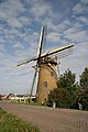
The Hoekse Waard is an island between the Oude Maas, Dordtsche Kil, Hollands Diep, Haringvliet and Spui rivers in the province of South Holland in the Netherlands. The island, part of the namesake municipality of Hoeksche Waard, is a mostly agricultural region, south of the outskirts of Rotterdam. The Hoeksche Waard consists of reclaimed land (polders): after the Saint Elisabeth flood of 1421 most of the area was flooded. The land has been reclaimed gradually in the following centuries.

Voorne-Putten Island of South Holland province, Netherlands

Voorne-Putten is an island between the North Sea, the Brielse Meer and the rivers Oude Maas, Spui and Haringvliet in the province of South Holland in the Netherlands. Voorne-Putten consists of the two former islands Voorne and Putten. It used to be separated by the river Bernisse which silted up and made the two islands one. It has 160,000 inhabitants (2008). Recently the riverbed has been dredged, and the two islands have been reformed.

Numansdorp Town in South Holland, Netherlands

Numansdorp is a town and former municipality in the province South Holland in the Netherlands and is located on the island Hoeksche Waard near the Hollands Diep. On 1 January 1984, the municipalities Numansdorp and Klaaswaal were merged into one municipality called Cromstrijen. Cromstrijen was merged into the new municipality Hoeksche Waard in January 2019.

Kruiningen Village in Zeeland, Netherlands

Kruiningen is a village in the Dutch province of Zeeland. It is located in the municipality of Reimerswaal, about 5 km south of the village of Yerseke.

Nieuw-Beijerland Village in South Holland, Netherlands

Nieuw-Beijerland is a village in the Dutch province of South Holland. It is a part of the municipality of Hoeksche Waard, and lies about 3 km south of Spijkenisse.

Goudswaard Village in South Holland, Netherlands

Goudswaard is a village in the Dutch province of South Holland, located on the westernmost tip of the Hoeksche Waard, approximately 6 km south-west of Spijkenisse. Goudswaard was a separate municipality from 1817 until 1984, when it was merged with Nieuw-Beijerland, Zuid-Beijerland and Piershil to form the municipality of Korendijk.

Zuid-Beijerland Village in South Holland, Netherlands

Zuid-Beijerland is a village in the Dutch province of South Holland. It is a part of the municipality of Hoeksche Waard, and lies about 10 km south of Spijkenisse.

Heinenoord Village and former municipality in South Holland, Netherlands

Heinenoord is a village in the Dutch province of South Holland on the island Hoekse Waard. It is located about 10 km south of Rotterdam, in the municipality of Hoeksche Waard.

Maasdam Village in South Holland, Netherlands

Maasdam is a village in the Dutch province of South Holland. It is located about 14 km south of the city of Rotterdam, in the municipality of Hoeksche Waard, on the rural Hoeksche Waard island. From the 14th Century until around 1800, Maasdam was also the name of the local administrative area, the fief and later the "ambacht".

Mijnsheerenland Village in South Holland, Netherlands

Mijnsheerenland is a village and a former municipality on the Hoeksche Waard island in the Dutch province of South Holland with 4,435 inhabitants. It is located on the shores of the Binnenbedijkte Maas, about 14 km south of the city of Rotterdam, in the municipality of Hoeksche Waard. It was the only village in the former municipality Binnenmaas not built next to a dyke.

Westmaas Village in South Holland, Netherlands

Westmaas is a village in the Dutch province of South Holland. It is located about 14 km south of the city of Rotterdam, next to Mijnsheerenland in the municipality of Hoeksche Waard. In 2020, the population was 2065.

Oude Maas Distributary of the Rhine River in South Holland, Netherlands

The Oude Maas is a distributary of the river Rhine, and a former distributary of the river Maas, in the Dutch province of South Holland. It begins at the city of Dordrecht where the Beneden Merwede river splits into the Noord and the Oude Maas. It ends when it joins the Nieuwe Maas to form Het Scheur.

Blaaksedijk Hamlet in South Holland, Netherlands

Blaaksedijk is a hamlet on a dike in the Dutch province of South Holland. The village lies in the municipality of Hoeksche Waard. Blaaksedijk lies between Puttershoek, Mijnsheerenland and Heinenoord.

Kuipersveer is a hamlet in the Dutch province of South Holland and is part of the municipality Hoeksche Waard. The village lies next to the Oude Maas between the villages of Puttershoek and Heinenoord.

Hoeksche Waard (municipality) Municipality in South Holland, Netherlands

Hoeksche Waard is a municipality in the western Netherlands, in the province of South Holland, consisting of the eponymous Hoeksche Waard and Tiengemeten islands.

References

  1. 1 2 3 "Kerncijfers wijken en buurten 2021". Central Bureau of Statistics. Retrieved 4 May 2022.
  2. "Postcodetool for 3297AA". Actueel Hoogtebestand Nederland (in Dutch). Het Waterschapshuis. Retrieved 4 May 2022.
  3. Wet samenvoeging gemeenten Binnenmaas, Cromstrijen, Korendijk, Oud-Beijerland en Strijen, 11 July 2018, accessed at overheid.nl
  4. Waardestelling Suikerfabriek Puttershoek rapportage Erfgoedhuis (mei 2009).pdf [ permanent dead link ](in Dutch)
  5. 1 2 Monumenten in Nederland. Zuid-Holland (in Dutch)
  6. Rustenburg wordt binnenkort gesloopt, Algemeen Dagblad 20 November 2001 (in Dutch)
  7. Woningbouwprojecten Gemeente Binnenmaas Archived 2013-02-22 at archive.today

Commons-logo.svg Media related to Puttershoek at Wikimedia Commons