
Tahquitz Peak is a granite, 8,846-foot-tall (2,696 m) rock formation located on the high western slope of the San Jacinto mountain range in Riverside County, Southern California, United States, above the mountain town of Idyllwild. Tahquitz has a steep approach hike, leading to a roughly 1000-foot face. Tahquitz, which can refer to both the rock outcrop and the outcrop's parent peak, is a popular hiking destination to the fire lookout station and the rock climbing area.

Mount Whitney is the highest mountain in the contiguous United States and the Sierra Nevada, with an elevation of 14,505 feet (4,421 m). It is in East–Central California, on the boundary between California's Inyo and Tulare counties, 84.6 miles (136.2 km) west-northwest of North America's lowest point, Badwater Basin in Death Valley National Park, at 282 ft (86 m) below sea level. The mountain's west slope is in Sequoia National Park and the summit is the southern terminus of the John Muir Trail, which runs 211.9 mi (341.0 km) from Happy Isles in Yosemite Valley. The eastern slopes are in Inyo National Forest in Inyo County.

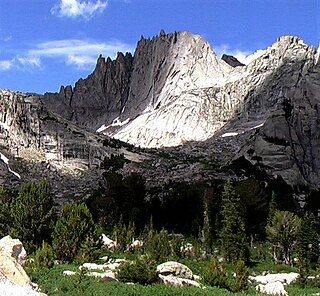
The Minarets are a series of jagged peaks located in the Ritter Range, a sub-range of the Sierra Nevada in the state of California. They are easily viewed from Minaret Summit, which is accessible by auto. Collectively, they form an arête, and are a prominent feature in the Ansel Adams Wilderness which was known as the Minaret Wilderness until it was renamed in honor of Ansel Adams in 1984.

Shiprock is a monadnock rising nearly 1,583 feet (482.5 m) above the high-desert plain of the Navajo Nation in San Juan County, New Mexico, United States. Its peak elevation is 7,177 feet (2,187.5 m) above sea level. It is about 10.75 miles (17.30 km) southwest of the town of Shiprock, which is named for the peak.

Steve Roper is a noted climber and historian of the Sierra Nevada in the United States. He along with Allen Steck are the founding editors of the Sierra Club journal Ascent.

The Cirque of the Towers is located in the Wind River Range Wyoming, U.S., part of which is in the Bridger Wilderness in Bridger-Teton National Forest, while the remainder is in the Popo Agie Wilderness in Shoshone National Forest. Located in the southern section of the Wind River Range, the cirque is a very popular destination for technical rock climbers. Climber Orrin Bonney gave the area its current name in 1941 after his survey of the cirque. Prior to this, few if any visitors had ventured into the cirque due to the remote location. The cirque is an almost circular hole or valley carved by a glacier that retreated over 8,000 years ago. As is true with the rest of the Winds, the mountains are composed almost entirely of granite. The Continental Divide spans the crest of the main peaks.
Crestone Needle is a high mountain summit of the Crestones in the Sangre de Cristo Range of the Rocky Mountains of North America. The 14,203-foot (4,329 m) fourteener is located 6.9 miles (11.1 km) east-southeast of the Town of Crestone in Saguache County, Colorado, United States. The Crestones are a cluster of high summits in the Sangre de Cristo Range, comprising Crestone Peak, Crestone Needle, Kit Carson Peak, Challenger Point, Humboldt Peak, and Columbia Point. They are usually accessed from common trailheads.

Fifty Classic Climbs of North America is a climbing guidebook and history written by Steve Roper and Allen Steck. It is considered a classic piece of climbing literature, known to many climbers as simply "The Book", and has served as an inspiration for more recent climbing books, such as Mark Kroese's Fifty Favorite Climbs. Though much of the book's contents are now out of date, it is still recognized as a definitive text which goes beyond the traditional guidebook.

Fairview Dome is a prominent granite dome in Yosemite National Park, located 1.8 miles (2.9 km) north of Cathedral Peak and 4 miles (6.4 km) west of Tuolumne Meadows. Near Fairview Dome is Marmot Dome, linked by an area called Razor Back. Northwest is Hammer Dome.

Lover's Leap is a steep granite cliff band in El Dorado County, California, United States, a landmark which catches the eye as one travels by, and a popular destination for climbers. The origin of its name is unknown, but common to most Lover's Leaps, one version from local folklore says two Native Americans lovers leapt to their deaths from the summit.

Fisher Towers are a series of towers made of Cutler sandstone capped with Moenkopi sandstone and caked with a stucco of red mud located near Moab, Utah. The Towers are named for a miner who lived near them in the 1880s. The Towers are world-renowned as a subject for photography and for its classic rock climbing routes.

The East Face of Mount Whitney is a technical alpine rock climbing route and is featured in Fifty Classic Climbs of North America. Mount Whitney is the highest peak in the contiguous United States.
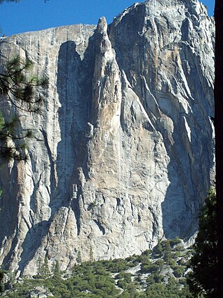
Lost Arrow Spire is a detached pillar in Yosemite National Park, in Yosemite Valley, California, located immediately adjacent to Upper Yosemite Falls. The structure includes the Lost Arrow Spire Chimney route which is recognized in the historic climbing text Fifty Classic Climbs of North America. The spire is the location for a dramatic Tyrolean traverse, which has since become an iconic slackline.
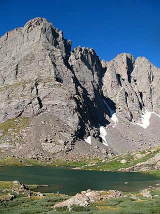
Petit Grepon is a semi-detached spire in Colorado's Rocky Mountain National Park. It is one of the "Cathedral Spires" which also includes: Sharkstooth, The Saber, and The Foil. The South Face route of Petit Grepon is described in the historic climbing text Fifty Classic Climbs of North America and considered a classic around the world.

Hallett Peak is a mountain summit in the northern Front Range of the Rocky Mountains of North America. The 12,720-foot (3,877 m) peak is located in the Rocky Mountain National Park Wilderness, 10.1 miles (16.2 km) southwest by west of the Town of Estes Park, Colorado, United States, on the Continental Divide between Grand and Larimer counties.

Titan Tower, also known as The Titan, is the largest of the Fisher Towers near Moab and Castle Valley, Utah. It has also been attributed to be the largest, free-standing, natural tower in the United States. The tower contains the Finger of Fate Route, first climbed in 1962, which is recognized in the historic climbing text Fifty Classic Climbs of North America and considered a classic around the world.

Charlotte Dome is a granite dome in California's Kings Canyon National Park. It lies to the southeast of Glacier Monument and north of Bubbs Creek. It is most easily accessed from the Onion Valley trailhead to the east. The South Face Route is featured in Fifty Classic Climbs of North America. This climb is a grade III, class 5.7.

Jules Marquard Eichorn was an American mountaineer, environmentalist, and music teacher.
Allen Steck is an American mountaineer and rock climber. He is a native of Oakland, California.
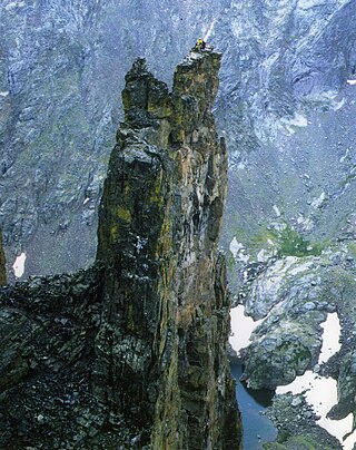
Wolfs Head is a mountain located in the southern Wind River Range in the U.S. state of Wyoming. Wolfs Head is on the northwest side of the Cirque of the Towers, a popular climbing area. The peak is just north of Overhanging Tower and connected to Pingora Peak by a narrow arête. The East Ridge route on the Wolf's Head is recognized in the historic climbing text Fifty Classic Climbs of North America and considered a classic climb. Wolfs Head is situated on the Continental Divide.
