
Grand Teton is the highest mountain of the Teton Range in Grand Teton National Park at 13,775 feet (4,199 m) in Northwest Wyoming. Below its north face is Teton Glacier. The mountain is a classic destination in American mountaineering via the Owen-Spalding route, the North Ridge and North Face.

Fossil Mountain is located in the Teton Range, within the Jedediah Smith Wilderness of Caribou-Targhee National Forest, U.S. state of Wyoming.

Mount Moran is a mountain in Grand Teton National Park of western Wyoming, USA. The mountain is named for Thomas Moran, an American western frontier landscape artist. Mount Moran dominates the northern section of the Teton Range rising 6,000 feet (1,800 m) above Jackson Lake. Several active glaciers exist on the mountain with Skillet Glacier plainly visible on the monolithic east face. Like the Middle Teton in the same range, Mount Moran's face is marked by a distinctive basalt intrusion known as the Black Dike.

Schoolroom Glacier is a small glacier in Grand Teton National Park in the U.S. state of Wyoming. This Teton Range glacier lies adjacent to the south Cascade Canyon trail at an altitude of 10,400 ft (3,200 m), approximately 12 mi (19 km) from the trailhead at Jenny Lake. The glacier has many of the classic textbook details of a glacier, namely, well defined terminal and lateral moraines, crevasses, a proglacial lake and related features which led to the naming schoolroom.

Middle Teton is the third-highest peak in the Teton Range, in the U.S. state of Wyoming. Located within Grand Teton National Park, the peak is immediately southwest of Grand Teton, from which it is separated by a broad high ridge at 11,600 feet (3,540 m), known to local climbers as the Lower Saddle. The Middle Teton Glacier is located on the eastern slopes of the peak.

Signal Mountain is an isolated summit standing 7,720 feet (2,350 m) above sea level. The mountain is located in Grand Teton National Park in the U.S. state of Wyoming. The next closest higher summit is more than 10 miles (16 km) distant, and this isolation provides sweeping views of the Teton Range, much of the northern Jackson Hole area as well as the Snake River. Though located adjacent to the Tetons, Signal Mountain was not formed in the same manner or period. The mountain originally was formed by volcanic ashfall from one of the eruptions of the Yellowstone hotspot. The peak is also partially a glacial moraine formed by a receding glacier that came south out of the Yellowstone icecap. This same glacier also created neighboring Jackson Lake.

Thor Peak is in the northern Teton Range, Grand Teton National Park, in the U.S. state of Wyoming. Mount Moran is 1 mile (1.6 km) to the east. The summit is the eighth-highest in the Teton Range. Several semi-permanent snowfields as well as the Triple Glaciers are located on the east and northern slopes of the mountain. While the easiest route up the mountain, the south slope, is only rated a class 4, the mountain's remoteness and difficulty of approach make it a challenging mountain to summit.

Symmetry Spire is located in the Teton Range, Grand Teton National Park in the U.S. state of Wyoming. The mountain, first climbed via the east ridge route on August 20, 1929, by Fritiof Fryxell and Phil Smith, towers above the northwest shore of Jenny Lake and Cascade Canyon. The scenic Lake of the Crags, a cirque lake or tarn, is located northwest of the summit and is accessed by way of Hanging Canyon. Popular with mountaineers, the spire has numerous challenging cliffs.
Cloudveil Dome is located in the Teton Range, Grand Teton National Park, Wyoming, immediately southeast of Grand Teton. The peak is in the central portions of the range, immediately east of South Teton and is sometimes considered to be part of what is collectively known as the Cathedral Group. Cloudveil Dome rises to the south of Garnet Canyon. The peak has a variety of mountaineering routes that are often overlooked since more popular climbing zones are nearby.

Garnet Canyon is located in Grand Teton National Park in the U.S. state of Wyoming. The canyon was formed by retreating glaciers which reached their last glacial maximum around 15,000 years ago. While Garnet Canyon is a less popular destination for recreational hikers than nearby Cascade Canyon or Death Canyon, it is an important approach to many significant and popular mountaineering climbs including routes found on Grand Teton, Middle Teton, South Teton and Disappointment Peak.

Static Peak is located in the Teton Range, Grand Teton National Park, in the U.S. state of Wyoming. Located .48 miles (0.77 km) southeast of Buck Mountain, the summit is also east of the Alaska Basin Trail, from a point known as Static Peak Divide, the summit can be climbed in a scramble. Below the summit on the north face, a small remnant glacier persists, sheltered from direct sunlight by steep cliffs. Timberline Lake lies to the north of the peak.

Teton Glacier is a mountain glacier located below the north face of Grand Teton in Grand Teton National Park, Wyoming, United States. Its neighbors are Mount Owen to the west and Teewinot Mountain 12,330 feet (3,758 m) to the north.
Teepe Glacier is below the northeast face of Teepe Pillar in Grand Teton National Park, Wyoming, United States. The glacier is immediately southeast of Grand Teton in the heart of the Cathedral Group collection of high peaks in the Teton Range. Between 1967 and 2006, Teepe Glacier lost approximately 60 percent of its surface area, shrinking from 13 to 5 acres.

Skillet Glacier is in Grand Teton National Park, Wyoming, United States. The glacier is situated on the eastern cliffs of Mount Moran and is easily seen from Jackson Hole. The shape of the glacier led to the naming as the uppermost section of the glacier is long and narrow and then broadens abruptly more than halfway down the mountain into a larger area, giving it the shape of a skillet or frying pan. The glacier is one of twelve that remain in Grand Teton National Park and one of five glaciers located on Mount Moran. Mountain climbers consider the Skillet Glacier route to be the fastest and one of the easiest ways to climb Mount Moran, and was the route taken when the peak was first climbed in 1922, though it is rarely used in late summer due to poor footing. On November 21, 1950, A DC-3 crashed into Mount Moran, adjacent to Skillet Glacier, killing all 21 passengers aboard. The remains of the passengers and the plane are still on the mountain.
Falling Ice Glacier is located in the Grand Teton National Park, Wyoming, United States. The glacier is situated on the southeastern cliffs of Mount Moran and can be seen from Jackson Hole. Runoff from the glacier flows into Leigh Lake. The glacier is located in a high altitude cirque and is along one of the major climbing routes to the summit of Mount Moran. All of the existing glaciers in Grand Teton National Park were created during the Little Ice Age (1350–1850 A.D.) and have been in a general state of retreat since the mid-19th century.
Triple Glaciers are in Grand Teton National Park, Wyoming, United States. The glaciers are disconnected from each other and occupy three separate cirques on the northwest face of Mount Moran and northeast of Thor Peak. The glaciers are unofficially referred to as East, Middle and West Triple Glacier.

Petersen Glacier is in Grand Teton National Park, Wyoming, United States. The glacier is in a cirque to the west and above north Cascade Canyon at an altitude of approximately 10,000 feet (3,000 m). The glacier is named after Frank Petersen, one of the first mountaineers to climb Grand Teton in 1898. Runoff from the glacier is heavy in rock flour which turns the waters of Mica Lake turquoise in appearance. The glacier is no longer visible in satellite imagery, indicating it may have disappeared. All of the existing glaciers in Grand Teton National Park were created during the Little Ice Age (1350-1850) and have been in a general state of retreat since the mid-19th century.

Minor Glacier is in Bridger-Teton National Forest, in the U.S. state of Wyoming on the west side of the Continental Divide in the northern Wind River Range. Minor Glacier is in the Bridger Wilderness and is part of the largest grouping of glaciers in the American Rocky Mountains. The glacier is situated below the west flank of Gannett Peak, the tallest mountain in Wyoming.
Hanging Canyon is located in Grand Teton National Park, in the U. S. state of Wyoming. The canyon was formed by glaciers which retreated at the end of the last glacial maximum approximately 15,000 years ago, leaving behind a U-shaped valley. Hanging Canyon is south of Mount Saint John and north of Symmetry Spire. The canyon is northwest of Jenny Lake and within the canyon lies Lake of the Crags, Ramshead Lake and Arrowhead Pool.
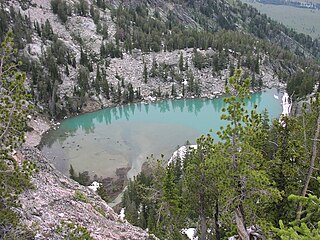
Delta Lake is located in Grand Teton National Park, in the U.S. state of Wyoming. Delta Lake is situated in Glacier Gulch and is fed rock flour from the Teton Glacier, which turns the water turquoise in appearance. It has been an increasingly popular hiking destination in the park, with the number of hikers increasing 164% from 2016 to 2018. The easiest walk to the lake is by way of the a hike commencing from the Lupine Meadows trailhead. Following the trail to Surprise and Amphitheater Lakes and an off trail effort to the north from Surprise Lake provides access to Delta Lake. The effort is considered strenuous for even getting to Surprise Lake is nearly a ten mile roundtrip with over 3,000 feet (910 m) of elevation gain. Below Delta Lake lies Glacier Falls, an intermittent 300-foot (91 m) waterfall.


