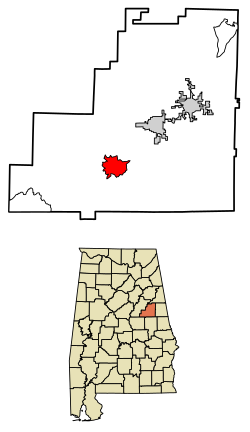
Millerville, Alabama | |
---|---|
Coordinates: 33°11′29″N85°55′33″W / 33.19139°N 85.92583°W Coordinates: 33°11′29″N85°55′33″W / 33.19139°N 85.92583°W | |
Country | United States |
State | Alabama |
County | Clay |
Area | |
• Total | 6.72 sq mi (17.41 km2) |
• Land | 6.70 sq mi (17.35 km2) |
• Water | 0.02 sq mi (0.06 km2) |
Elevation | 856 ft (261 m) |
Population (2020) | |
• Total | 303 |
• Density | 45.23/sq mi (17.46/km2) |
Time zone | UTC-6 (Central (CST)) |
• Summer (DST) | UTC-5 (CDT) |
Area code(s) | 256 & 938 |
GNIS feature ID | 160110 [2] |
Millerville is a census-designated place and unincorporated community in Clay County, Alabama, United States. Its population was 303 as of the 2020 census.
Historical population | |||
---|---|---|---|
Census | Pop. | %± | |
2020 | 303 | — | |
U.S. Decennial Census [3] |
India is the second most populated country in the world with nearly a fifth of the world's population. According to the 2019 revision of the World Population Prospects the population stood at 1,352,642,280.
Clay County is a county in the east central part of the U.S. state of Alabama. As of the 2020 census the population was 14,236. Its county seat is Ashland. Its name is in honor of Henry Clay, famous American statesman, member of the United States Senate from Kentucky and United States Secretary of State in the 19th century. It was the last dry county in Alabama with no wet cities within its boundaries, until a vote on March 1, 2016 approved the sale of alcohol in Lineville and Ashland.
The United States had an official resident population of 331,449,281 on April 1, 2020, according to the U.S. Census Bureau. This figure includes the 50 states and the District of Columbia but excludes the population of five unincorporated U.S. territories as well as several minor island possessions. The United States is the third most populous country in the world. The Census Bureau showed a population increase of 0.8% for the twelve-month period ending in July 2012. Though high by industrialized country standards, this is below the world average annual rate of 1.1%. The total fertility rate in the United States estimated for 2020 is 1.638 children per woman, which is below the replacement fertility rate of approximately 2.1.
Douglas County is a county in the U.S. state of Minnesota. As of the 2020 United States Census, the population was 39,006. Its county seat is Alexandria.
Acadia Parish is a parish located in the U.S. state of Louisiana. At the 2020 U.S. census, the population was 57,576. The parish seat is Crowley. The parish was founded from parts of St. Landry Parish in 1886, and later an election was held to determine the parish seat, ending when Crowley beat Rayne and Prairie Hayes. Acadia Parish is included in the Lafayette metropolitan statistical area.
Blackstone is a town in Worcester County, Massachusetts, United States. The population was 9,026 at the 2010 census. It is a part of the Providence metropolitan area.
Millerville Township is a township in Douglas County, Minnesota, United States. The population was 350 at the 2000 census.
Urbank is a city in Otter Tail County, Minnesota, United States. The population was 54 at the 2010 census.
Millerville is a city in Douglas County, Minnesota, United States. The population was 106 at the 2010 census.
Louisville is a town in St. Lawrence County, New York, United States. The population was 3,145 at the 2010 census. The town is reportedly named after French king Louis XIV, but is pronounced as "Lewis-ville."
The West Coast of the United States, also known as the Pacific Coast, Pacific states, and the western seaboard, is the coastline along which the Western United States meets the North Pacific Ocean. The term typically refers to the contiguous U.S. states of California, Oregon, and Washington, but sometimes includes Alaska and Hawaii, especially by the United States Census Bureau as a U.S. geographic division.
The Northern United States, commonly referred to as the American North, the Northern States, or simply the North, is a geographical or historical region of the United States.
Combined statistical area (CSA) is a United States Office of Management and Budget (OMB) term for a combination of adjacent metropolitan (MSA) and micropolitan statistical areas (µSA) across the 50 US states and the territory of Puerto Rico that can demonstrate economic or social linkage. The OMB defines a CSA as consisting of various combinations of adjacent metropolitan and micropolitan areas with economic ties measured by commuting patterns. These areas that combine retain their own designations as metropolitan or micropolitan statistical areas within the larger combined statistical area.
The United States has a racially and ethnically diverse population. At the federal level, race and ethnicity have been categorized separately. The most recent United States Census officially recognized five racial categories as well as people of two or more races. The Census Bureau also classified respondents as "Hispanic or Latino" or "Not Hispanic or Latino", identifying Hispanic and Latino as an ethnicity, which comprises the largest minority group in the nation. The Census also asked an "Ancestry Question," which covers the broader notion of ethnicity, in the 2000 Census long form and the 2010 American Community Survey; the question worded differently on “origins” will return in the 2020 Census.
Americans are the citizens and nationals of the United States of America. Although citizens and nationals make up the majority of Americans, many dual citizens, expatriates and permanent residents could also legally claim American nationality. The United States is home to people of many ethnic origins. As a result, American culture and law does not equate nationality with race or ethnicity, but with bona fide citizenship and an oath of permanent allegiance.