
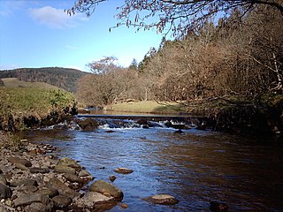
The River Tyne is a river in Scotland. It rises in the Moorfoot Hills in Midlothian near Tynehead to the south of Edinburgh, at the junction of the B6458 and the B6367. It continues approximately 30 miles northeast, and empties into the North Sea near Belhaven.

Tynedale is an area and former local government district in south-west Northumberland, England. The district had a resident population of 58,808 according to the 2001 Census. Its main towns were Hexham, Haltwhistle and Prudhoe. The district contained part of Hadrian's Wall and the southern part of Northumberland National Park.

The A69 is a major northern trunk road in England, running east–west across the Pennines, through the counties of Tyne and Wear, Northumberland and Cumbria. Originally, the road started in the centre of Newcastle upon Tyne then later near Birtley, but since the creation of the A1 Western Bypass around Newcastle upon Tyne, it now starts at Denton Burn, a suburb of Newcastle upon Tyne.

Langstone is a village near Havant, Hampshire in the south east of England in Portsmouth. It has good railway connections to London, Southampton, Portsmouth and Brighton, from the nearby Havant railway station. There are many large gated detached houses on the main road, "Langstone Road" and on the roads surrounding this. It has a sailing club, several architecturally unusual buildings, and several historically significant buildings, including a converted (water) millhouse and a converted 18th century windmill, the latter of which is a local landmark.
Kip Water, also known as the River Kip, is a short river in Inverclyde, Scotland which gives the village of Inverkip its name. It originates at Cornalees in the hills between Inverkip and Greenock and runs through Shielhill Glen, Dunrod Glen and the Kip Valley before entering the Firth of Clyde at Kip Marina in Inverkip.

Bardon Mill is a small village in Northumberland, within the vicinity of the ancient Hadrian's Wall. It is located around 10.5 miles (17 km) from Hexham, 26.5 miles (43 km) from Carlisle, and 32 miles (51 km) from Newcastle upon Tyne.
Ovingham is a civil parish and village in the Tyne Valley of south Northumberland, England. It lies on the River Tyne 10 miles (16 km) east of Hexham with neighbours Prudhoe, Ovington, Wylam and Stocksfield.

Hadrian's Wall Path is a long-distance footpath in the north of England, which became the 15th National Trail in 2003. It runs for 84 miles (135 km), from Wallsend on the east coast of England to Bowness-on-Solway on the west coast. For most of its length it is close to the remains of Hadrian's Wall, the defensive wall built by the Romans on the northern border of their empire. This is now recognised as part of the "Frontiers of the Roman Empire" World Heritage Site.

Bardon Mill is a railway station on the Tyne Valley Line, which runs between Newcastle and Carlisle via Hexham. The station, situated 27+1⁄2 miles (44 km) east of Carlisle, serves the village of Bardon Mill in Northumberland, England. It is owned by Network Rail and managed by Northern Trains.

Millhouses Park is a public urban park located in the Millhouses neighbourhood in south of Sheffield, England. It is a 12.87-hectare (31.8-acre) park stretching approximately 0.75 miles (1.2 km) along the floor of the valley of the River Sheaf, sandwiched between Abbeydale Road South (A621) and the railway tracks of the Midland Main Line.

Melkridge is a village and civil parish in Northumberland, England, on the river South Tyne. The village of Melkridge is in the south of the parish, and is about two miles (3 km) east of Haltwhistle along the A69 road. At the 2001 the civil parish had a population of 212, increasing slightly to 216 at the 2011 Census.
Henshaw is a small village and civil parish in Northumberland, within the vicinity of the ancient Hadrian's Wall. It is located around 11.5 miles (19 km) from Hexham, 25.5 miles (41 km) from Carlisle, and 33 miles (53 km) from Newcastle upon Tyne.

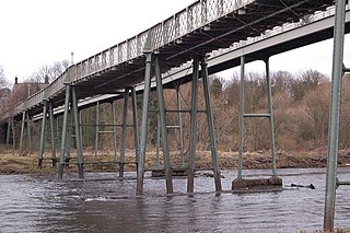
The Tyne Valley Line is a 58-mile (93 km) route, linking Newcastle upon Tyne with Hexham and Carlisle. The line follows the course of the River Tyne through Tyne and Wear and Northumberland. Five stations and two viaducts on the route are listed structures.

Teesquay Millennium Footbridge is a footbridge crossing east-west over the River Tees, in Stockton-on-Tees in the Northeast of England. The bridge links Teesdale Business Park and the University of Durham, Queen's Campus in Thornaby-on-Tees to the Castlegate (shopping) Centre in Stockton-on-Tees High Street. The bridge crosses the Teesdale Way cycle route, River Tees and the A1035 Riverside Road. Funding for the bridge was from Stockton-on-Tees Council, the European Regional Development Fund, One NorthEast and English Partnerships.

Corby Bridge is a railway viaduct adjacent to and immediately east of Wetheral railway station at Wetheral, near Carlisle, in north-west England, begun in 1830 and completed in 1834. It is 660 feet (200 m) long and 100 feet (30 m) high, and has been Grade I listed since 1 April 1957.

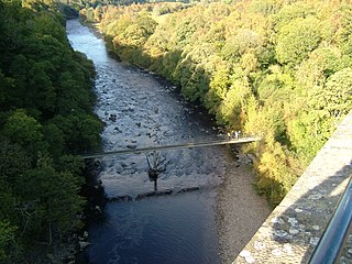
Old Haydon Bridge is a footbridge across the River South Tyne providing access between the Northern and Southern sides of the village of Haydon Bridge, Northumberland, England.

Featherstone Castle Footbridge is a wooden-decked girder bridge across the River South Tyne at Featherstone Castle in Northumberland.
Lambley Footbridge is a wooden bridge across the River South Tyne at Lambley in Northumberland.

The Great Flood of 1771 affected several rivers, including the Tyne, Tees, Wear and Eden and settlements across northern England from 16 and 17 November 1771. Its cause was a sudden thaw of the ice in upper Teesdale, a cloud burst over the Pennines and a continuous period of rain.

