
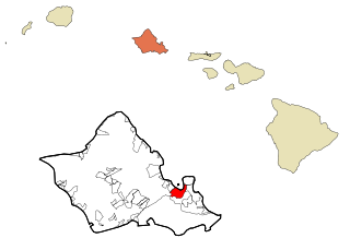
Kailua is an unincorporated city in Hawaiʻi County, Hawaii, United States, in the North Kona District of the Island of Hawaiʻi. The population was 11,975 at the 2010 census, up from 9,870 at the 2000 census. It is the center of commerce and of the tourist industry on West Hawaiʻi. Its post office is designated Kailua-Kona to differentiate it from Kailua located on the windward side of Oʻahu island, and it is sometimes referred to as Kona in everyday speech. The city is served by Kona International Airport, located just to the north in the adjacent Kalaoa CDP. Kailua-Kona was the closest major settlement to the epicenter of the 2006 Kiholo Bay earthquake.

Waikoloa Village is a census-designated place (CDP) in Hawaiʻi County, Hawaiʻi, United States. The population was 6,362 at the 2010 census, up from 4,806 at the 2000 census. The name Waikoloa is used by the local post office.

Waimea is a census-designated place (CDP) in Hawaiʻi County, Hawaiʻi, United States. The population was 7,028 at the 2000 census and 9,212 at the 2010 census. Since each U.S. state cannot have more than one post office of the same name, and there is a post office in Waimea, Kauai County, the official U.S. Post Office designation for Waimea is Kamuela, although this name is only used by the post office, not by locals or the local government. The name Waimea means reddish water.

Kailua is a census-designated place (CDP) in Honolulu County, Hawaii, United States. It lies in the Koʻolaupoko District of the island of Oʻahu on the windward coast at Kailua Bay. It is in the judicial district and the ahupua'a named Ko'olaupoko. It is 12 miles (19 km) northeast of Honolulu – over Nu‘uanu Pali. The population was 38,635 at the 2010 census.
Kāneʻohe is a census-designated place (CDP) included in the City and County of Honolulu and located in Hawaiʻi state District of Koʻolaupoko on the island of Oʻahu. In the Hawaiian language, kāne ʻohe means "bamboo man". According to an ancient Hawaiian story a local woman compared her husband's cruelty to the sharp edge of cutting bamboo; thus the place was named Kāneʻohe or "Bamboo man". The population was 34,597 at the 2010 census. Kāneʻohe is the largest of several communities along Kāneʻohe Bay and one of the two largest residential communities on the windward side of Oʻahu. The commercial center of the town is spread mostly along Kamehameha Highway.

Hualālai is an active volcano on the island of Hawaiʻi in the Hawaiian Islands. It is the westernmost, third-youngest and the third-most active of the five volcanoes that form the island of Hawaiʻi, following Kīlauea and the much larger Mauna Loa. Its peak stands 8,271 feet (2,521 m) above sea level. Hualālai is estimated to have risen above sea level about 300,000 years ago. Despite maintaining a very low level of activity since its last eruption in 1801, and being unusually inactive for the last 2,000 years, Hualālai is still considered active, and is expected to erupt again some time within the next century. The relative unpreparedness of the residents in the area caused by the lull in activity would worsen the consequences of such an event.

Ellison Onizuka Kona International Airport at Keāhole is on the Island of Hawaiʻi, in Kalaoa CDP, Hawaiʻi County, Hawaiʻi, United States. The airport serves leeward, or Western Hawaiʻi island, including the town of Kailua-Kona and the resorts of the North Kona and South Kohala districts.
The following is an alphabetical list of articles related to the U.S. state of Hawaii:

Blue Hawaii is a 1961 American musical romantic comedy film set in the state of Hawaii, starring Elvis Presley and directed by Norman Taurog. The screenplay by Hal Kanter was nominated by the Writers Guild of America in 1962 in the category of Best Written American Musical. The movie opened at no. 2 in box office receipts for that week and despite mixed reviews from critics, finished as the 10th top-grossing movie of 1961 and 14th for 1962 on the Variety national box office survey, earning $5 million. The film won a fourth place prize Laurel Award in the category of Top Musical of 1961.

G.I. Blues is a 1960 American musical comedy film directed by Norman Taurog and starring Elvis Presley, Juliet Prowse, and Robert Ivers. The movie was filmed at Paramount Pictures studio, with some pre-production scenery shot on location in Germany before Presley's release from the army. The movie reached #2 on the Variety weekly national box office chart in 1960. The movie won a 2nd place or runner-up prize Laurel Award in the category of Top Musical of 1960.

Girls! Girls! Girls! is a 1962 Golden Globe-nominated American musical comedy film starring Elvis Presley as a penniless Hawaiian fisherman who loves his life on the sea and dreams of owning his own boat. "Return to Sender", which reached #2 on the Billboard pop singles chart, is featured in the movie. The movie opened at #6 on the Variety box office chart and finished the year at #31 on the year-end list of the top-grossing movies of 1962. The movie earned $2.6 million at the box office.

Saint Michael the Archangel Catholic Church is a parish of the Roman Catholic Church of Hawaiʻi in the United States. Located in Kailua-Kona on the Big Island of Hawaiʻi, 75-5769 Ali'i Drive, coordinates 19°38′13″N155°59′28″W. The church falls under the jurisdiction of the Diocese of Honolulu and its bishop. On June 17, 1839, Kamehameha III declared religious freedom in the Kingdom in the Edict of Toleration. A mission named after Saint Michael the Archangel was founded in 1840, the first Catholic Church on the island. The first services were in a small grass hut. Governor John Adams Kuakini gave the land South of Mokuʻaikaua Church to the Catholic mission in 1841. The present church was completed in 1850 under Father Joachim Merechel. He was buried inside the church in 1859. In 1940 Father Benno Evers constructed a grotto of coral from Kailua Bay over the site of the original well.
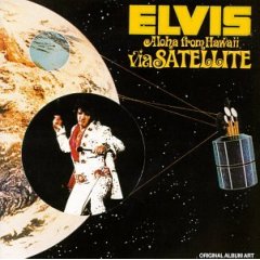
Aloha from Hawaii Via Satellite is a concert that was headlined by Elvis Presley, and was broadcast live via satellite on January 14, 1973. The concert took place at the Honolulu International Center (HIC) in Honolulu and aired in over 40 countries across Asia and Europe. Despite the satellite innovation, NBC did not broadcast an edited version of the concert in the United States until April 4, 1973 because the concert took place the same day as Super Bowl VII. The decision paid off handsomely for the network, attracting 51 percent of the television viewing audience to become NBC’s highest rated program of the year. The show was the most expensive entertainment special at the time, costing $2.5 million.

The Hawaiʻi Belt Road is a modern name for the Māmalahoa Highway and consists of Hawaiʻi state Routes 11, 19, and 190 that encircle the Island of Hawaiʻi. The southern section, between Hilo and Kailua-Kona is numbered as Route 11. The section between Hilo and Waimea is Route 19. Between Waimea and Kailua-Kona, the road is split in two: the original "mauka" route and a "makai" Route 19, completed in 1975, which serves as access to the Kona and Kohala Coast resorts. In the Hawaiian language, mauka means "towards the mountain" and makai means "towards the sea". These terms are commonly used in travel directions.
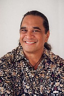
Wilfred Nalani "Moe" Keale was a musician of Hawaiian music, a ukulele virtuoso, and an American actor. He was the uncle and major musical influence of Israel Kamakawiwoʻole.

Kona Brewing Company is a brewery in Kailua-Kona on Hawaii's Big Island. As of October 1, 2010, it has been owned by Craft Brew Alliance. Kona's year-round beers include Longboard Island Lager, Big Wave Golden Ale, and Fire Rock Pale Ale. They have three rotating seasonal brews in their Aloha Series including Koko Brown, Wailua Wheat and Pipeline Porter. Kona Brewing Company distributes its beers in 36 states and 10 different countries.

Old Kona Airport State Recreation Area is a park built on the site of an old landing strip just North of Kailua, Hawaii County, Hawaii.

Kainaliu is a small community in Hawaiʻi County, Hawaiʻi, United States.

Henry Nicholas Greenwell was an English merchant credited with establishing Kona coffee as an internationally known brand. His family became major land-holders in the Kona District of the island of Hawaiʻi. The Greenwell Store is now a museum and historical center.


