Mining is the extraction of valuable geological materials and minerals from the surface of the Earth. Mining is required to obtain most materials that cannot be grown through agricultural processes, or feasibly created artificially in a laboratory or factory. Ores recovered by mining include metals, coal, oil shale, gemstones, limestone, chalk, dimension stone, rock salt, potash, gravel, and clay. The ore must be a rock or mineral that contains valuable constituent, can be extracted or mined and sold for profit. Mining in a wider sense includes extraction of any non-renewable resource such as petroleum, natural gas, or even water.

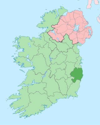
County Wicklow is a county in Ireland. The last of the traditional 32 counties, having been formed as late as 1606, it is part of the Eastern and Midland Region and the province of Leinster. It is bordered by the Irish Sea to the east and the counties of Wexford to the south, Carlow to the southwest, Kildare to the west, and South Dublin and Dún Laoghaire–Rathdown to the north.

Glendalough is a glacial valley in County Wicklow, Ireland, renowned for an Early Medieval monastic settlement founded in the 6th century by St Kevin. From 1825 to 1957, the head of the Glendalough Valley was the site of a galena lead mine. Glendalough is also a recreational area for picnics, for walking along networks of maintained trails of varying difficulty, and also for rock climbing.

Ireland is an island in Northern Europe in the north Atlantic Ocean. The island, of up to around 480 km (300 mi) north-south, and 275 km (171 mi) east-west, lies near the western edge of the European continental shelf, part of the Eurasian Plate. Its main geographical features include low central plains surrounded by coastal mountains. The highest peak is Carrauntoohil, which is 1,039 metres (3,409 ft) above sea level. The western coastline is rugged, with many islands, peninsulas, headlands and bays, while the southern and northern coasts feature a smaller number of substantial sea inlets, such as Lough Foyle and Cork Harbour; no part of the land is more than around 110 km (68 mi) from the sea. It was administratively divided into 32 counties, gathered in 4 provinces, though current arrangements, especially in Northern Ireland, differ from this model. The island is almost bisected by the River Shannon, which at 360.5 km (224 mi) with a 102.1 km (63 mi) estuary is the longest river in Ireland and flows south from County Cavan in the province of Ulster to form the boundary between Connacht and Leinster, and later Munster, and meet the Atlantic just south and west of Limerick. There are a number of sizeable lakes along Ireland's rivers, of which Lough Neagh is the largest.

Bray is a coastal town in north County Wicklow, Ireland. It is situated about 20 km (12 mi) south of Dublin city centre on the east coast. It has a population of 33,512 making it the tenth largest urban area within Ireland. Bray is home to Ardmore Studios, and some light industry is located in the town, with some business and retail parks on its southern periphery. Commuter links between Bray and Dublin are provided by rail, Dublin Bus and the M11 and M50 motorways. Parts of the town's northern outskirts are in County Dublin. The town is in a townland and civil parish of the same name.

Arklow is a town in County Wicklow on the southeast coast of Ireland. The town is overlooked by Ballymoyle Hill. It was founded by the Vikings in the ninth century. Arklow was the site of one of the bloodiest battles of the 1798 rebellion. Its proximity to Dublin led to it becoming a commuter town with a population of 13,163 as of the 2016 census. The 2022 census recorded a population of 13,399. The town is in a townland and civil parish of the same name.

The Wicklow Mountains form the largest continuous upland area in Ireland. They occupy the whole centre of County Wicklow and stretch outside its borders into the counties of Dublin, Wexford and Carlow. Where the mountains extend into County Dublin, they are known locally as the Dublin Mountains. The highest peak is Lugnaquilla at 925 metres.

Avoca is a small town near Arklow, in County Wicklow, Ireland. It is situated on the River Avoca.

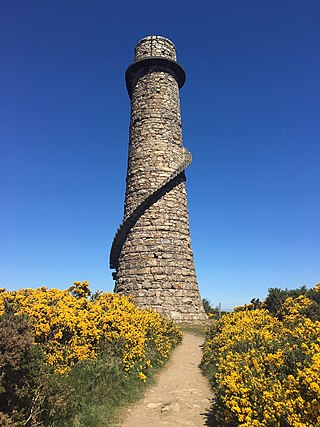
Ballycorusleadmines is a former lead mining and smelting centre located in the townland of the same name, near Kilternan in County Dublin, Ireland. The mine opened around 1807 and was taken over by the Mining Company of Ireland (MCI) in 1826 who owned and operated the site up until closure in 1913. After the mine was exhausted in the 1860s, Ballycorus continued to operate as a smelting facility receiving ore from other MCI sites such as the mines in Glendalough, County Wicklow. The most distinctive surviving remnant of the site is the ruin of the flue chimney that lies close to the summit of Carrickgollogan hill. Further down the slopes of the hill, many other former buildings and structures from the leadworks can also be found.
The mining industry in India is a major economic activity which contributes significantly to the economy of India. The gross domestic product (GDP) contribution of the mining industry varies from 2.2% to 2.5% only but going by the GDP of the total industrial sector, it contributes around 10% to 11%. Even mining done on small scale contributes 6% to the entire cost of mineral production. Indian mining industry provides job opportunities to around 700,000 individuals.
The primary natural resources of the Republic of Ireland include natural gas, petroleum, peat, copper, lead, dolomite, barite, limestone, gypsum, silver and zinc. Key industries based on these and other natural resources include fishing, mining, and various forms of agriculture and fish farming. The Department of Communications, Energy and Natural Resources is charged with the legislative protection of Ireland's natural resources.

Ashford, historically known as Ballymacahara, is a village in County Wicklow, Ireland. It lies on the River Vartry and at the meeting of the R772, R763 and R764 regional roads. The village was formerly on the main Dublin–Wexford route, the N11, but was bypassed by the new N11 in 2004. As of the 2022 census, the village had a population of 1,892 people.

Camaderry at 699 metres (2,293 ft), is the 90th-highest peak in Ireland on the Arderin scale, and the 112th-highest peak on the Vandeleur-Lynam scale. Camaderry is situated in the southern sector of the Wicklow Mountains range, and forms a broad horseshoe around the valley of Glendalough with the hydroelectric station at Turlough Hill 681 metres (2,234 ft), and the mountains of Conavalla 734 metres (2,408 ft), and Lugduff 652 metres (2,139 ft). Camaderry has a subsidiary summit, Camaderry South East Top 677 metres (2,221 ft), and both lie across the deep Wicklow Gap from Tonelagee 817 metres (2,680 ft), which sits on the "central spine" of the Wicklow range.

The Dublin Mountains Way is a waymarked long-distance trail in the Dublin Mountains, Counties South Dublin and Dún Laoghaire–Rathdown, Ireland. The route is approximately 42 kilometres long and runs from Shankill in the east to Tallaght in the west. It has been developed by the Dublin Mountains Partnership, an umbrella group of relevant state agencies and recreational users working to improve recreational facilities in the Dublin Mountains.
Desloge Consolidated Lead Company was a lead mining company in the Southeast Missouri Lead District that was operated by the Desloge family in the 19th and early 20th century. The Desloge lead operations in the "Old Lead Belt", in the eastern Ozark Mountains, helped Missouri become the world's premier lead mining area.

Carrickgollogan is a hill in Dún Laoghaire–Rathdown in Ireland, towards the southern border of the traditional County Dublin. It is 276 metres high, on the eastern edge of the Dublin Mountains, rising above the districts of Rathmichael and Shankill. Its summit is noted for the panoramic views it offers of south Dublin and north Wicklow.
Abraham Mills was an English mining company manager and geologist.

Kilbride, or Manor Kilbride, is a village, civil parish and electoral division in County Wicklow, Ireland, located at the western edge of the Wicklow Mountains in the barony of Talbotstown Lower.
Australian Kerosene Oil Company or 'A.K.O' mined and processed oil shale to produce kerosene, paraffin wax and candles, lubricating oil and greases, and other petroleum-based products, in New South Wales Australia. It is particularly associated with the site of its mine and works, at Joadja. At times, it also had other mining operations, at Airly and near Katoomba, and a soap and candle factory at Camellia. The company used the brand name 'Southern Cross' for its kerosene products.


