Related Research Articles

Orogeny is a mountain building process that takes place at a convergent plate margin when plate motion compresses the margin. An orogenic belt or orogen develops as the compressed plate crumples and is uplifted to form one or more mountain ranges. This involves a series of geological processes collectively called orogenesis. These include both structural deformation of existing continental crust and the creation of new continental crust through volcanism. Magma rising in the orogen carries less dense material upwards while leaving more dense material behind, resulting in compositional differentiation of Earth's lithosphere. A synorogenic process or event is one that occurs during an orogeny.
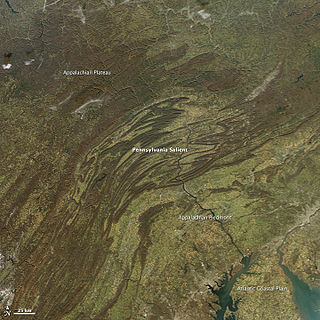
The geology of the Appalachians dates back more than 480 million years. The rocks exposed in today's Appalachian Mountains reveal elongate belts of folded and thrust faulted marine sedimentary rocks, volcanic rocks and slivers of ancient ocean floor – strong evidence that these rocks were deformed during plate collision. The birth of the Appalachian ranges marks the first of several mountain building plate collisions that culminated in the construction of the supercontinent Pangaea with the Appalachians and neighboring Anti-Atlas mountains near the center. These mountain ranges likely once reached elevations similar to those of the Alps and the Rocky Mountains before they were eroded.

The Acadian orogeny is a long-lasting mountain building event which began in the Middle Devonian, reaching a climax in the early Late Devonian. It was active for approximately 50 million years, beginning roughly around 375 million years ago, with deformational, plutonic, and metamorphic events extending into the Early Mississippian. The Acadian orogeny is the third of the four orogenies that formed the Appalachian orogen and subsequent basin. The preceding orogenies consisted of the Potomac and Taconic orogeny, which followed a rift/drift stage in the Late Neoproterozoic. The Acadian orogeny involved the collision of a series of Avalonian continental fragments with the Laurasian continent. Geographically, the Acadian orogeny extended from the Canadian Maritime provinces migrating in a southwesterly direction toward Alabama. However, the Northern Appalachian region, from New England northeastward into Gaspé region of Canada, was the most greatly affected region by the collision.

The Antler orogeny was a tectonic event that began in the early Late Devonian with widespread effects continuing into the Mississippian and early Pennsylvanian. Most of the evidence for this event is in Nevada but the limits of its reach are unknown. A great volume of conglomeratic deposits of mainly Mississippian age in Nevada and adjacent areas testifies to the existence of an important tectonic event, and implies nearby areas of uplift and erosion, but the nature and cause of that event are uncertain and in dispute. Although it is known as an orogeny, some of the classic features of orogeny as commonly defined such as metamorphism, and granitic intrusives have not been linked to it. In spite of this, the event is universally designated as an orogeny and that practice is continued here. This article outlines what is known and unknown about the Antler orogeny and describes three current theories regarding its nature and origin.

The Taconic orogeny was a mountain building period that ended 440 million years ago and affected most of modern-day New England. A great mountain chain formed from eastern Canada down through what is now the Piedmont of the East coast of the United States. As the mountain chain eroded in the Silurian and Devonian periods, sediments from the mountain chain spread throughout the present-day Appalachians and midcontinental North America.
In geology, clastic wedge usually refers to a thick assemblage of sediments--often lens-shaped in profile--eroded and deposited landward of a mountain chain; they begin at the mountain front, thicken considerably landwards of it to a peak depth, and progressively thin with increasing distance inland. Perhaps the best examples of clastic wedges in the United States are the Catskill Delta in Appalachia and the sequence of Jurassic and Cretaceous sediments deposited in the Cordilleran foreland basin in the Rocky Mountain region.

West Virginia's geologic history stretches back into the Precambrian, and includes several periods of mountain building and erosion. At times, much of what is now West Virginia was covered by swamps, marshlands, and shallow seas, accounting for the wide variety of sedimentary rocks found in the state, as well as its wealth of coal and natural gas deposits. West Virginia has had no active volcanism for hundreds of millions of years, and does not experience large earthquakes, although smaller tremors are associated with the Rome Trough, which passes through the western part of the state.
The geology of Saskatchewan can be divided into two main geological regions, the Precambrian Canadian Shield and the Phanerozoic Western Canadian Sedimentary Basin. Within the Precambrian shield exists the Athabasca sedimentary basin. Meteorite impacts have altered the natural geological formation processes. The prairies were most recently affected by glacial events in the Quaternary period.
This is a list of articles related to plate tectonics and tectonic plates.

The geology of Massachusetts includes numerous units of volcanic, intrusive igneous, metamorphic and sedimentary rocks formed within the last 1.2 billion years. The oldest formations are gneiss rocks in the Berkshires, which were metamorphosed from older rocks during the Proterozoic Grenville orogeny as the proto-North American continent Laurentia collided against proto-South America. Throughout the Paleozoic, overlapping the rapid diversification of multi-cellular life, a series of six island arcs collided with the Laurentian continental margin. Also termed continental terranes, these sections of continental rock typically formed offshore or onshore of the proto-African continent Gondwana and in many cases had experienced volcanic events and faulting before joining the Laurentian continent. These sequential collisions metamorphosed new rocks from sediments, created uplands and faults and resulted in widespread volcanic activity. Simultaneously, the collisions raised the Appalachian Mountains to the height of the current day Himalayas.

The geology of North America is a subject of regional geology and covers the North American continent, the third-largest in the world. Geologic units and processes are investigated on a large scale to reach a synthesized picture of the geological development of the continent.
The Wernecke Mountains are located in the East-central Yukon Territory of Canada. They have provided important wildlife habitat for animals such as grizzly bears and caribou as well as trapping and hunting land for the indigenous people of the Yukon for many centuries. They are the northernmost expression of the North American Cordillera, a chain of mountains stretching from Alaska to southern Mexico. This area has a northern climate characterized by short summers and long winters, with average temperatures from −26 °C (−15 °F) in the winter to 22 °C (72 °F) in the summer While essentially unpopulated, this area is well known for its rich mineral deposits, including gold, silver and copper.

The main points that are discussed in the geology of Iran include the study of the geological and structural units or zones; stratigraphy; magmatism and igneous rocks; ophiolite series and ultramafic rocks; and orogenic events in Iran.
The geology of Libya formed on top of deep and poorly understood Precambrian igneous and metamorphic crystalline basement rock. Most of the country is intra-craton basins, filled with thick layers of sediment. The region experienced long-running subsidence and terrestrial sedimentation during the Paleozoic, followed by phases of volcanism and intense folding in some areas, and widespread flooding in the Mesozoic and Cenozoic due to a long marine transgression. Libya has the largest hydrocarbon reserves in Africa, as well as deposits of evaporites.
The geology of Alberta encompasses parts of the Canadian Rockies and thick sedimentary sequences, bearing coal, oil and natural gas, atop complex Precambrian crystalline basement rock.
The geology of Nunavut began to form nearly three billion years ago in the Archean and the territory preserves some of the world's oldest rock units.

The geology of the State of New York is made up of ancient Precambrian crystalline basement rock, forming the Adirondack Mountains and the bedrock of much of the state. These rocks experienced numerous deformations during mountain building events and much of the region was flooded by shallow seas depositing thick sequences of sedimentary rock during the Paleozoic. Fewer rocks have deposited since the Mesozoic as several kilometers of rock have eroded into the continental shelf and Atlantic coastal plain, although volcanic and sedimentary rocks in the Newark Basin are a prominent fossil-bearing feature near New York City from the Mesozoic rifting of the supercontinent Pangea.
The geology of Venezuela includes ancient Precambrian igneous and metamorphic basement rocks, layered with sedimentary rocks from the Paleozoic and Mesozoic and thick geologically recent Cenozoic sediments with extensive oil and gas.
The geology of Argentina includes ancient Precambrian basement rock affected by the Grenville orogeny, sediment filled basins from the Mesozoic and Cenozoic as well as newly uplifted areas in the Andes.
References
- 1 2 Dietz, Robert S. and John C. Holden, 1966, Miogeoclines (Miogeosynclines) in Space and Time, Journal of Geology, Vol. 74, No. 5, Part 1 (Sep., 1966), pp. 566-583
- 1 2 Stewart, J. H. and F. G. Poole, Lower Paleozoic and Uppermost Precambrian Cordilleran Miogeocline, Great Basin, Western United States, Tectonics and Sedimentation, Vol. 22, 1974, P.28-57 doi : 10.2110/pec.74.22.0028
- ↑ Baldridge, W. Scott, Geology of the American Southwest, Cambridge University Press, 2004, pp. 76 - 90 ISBN 978-0-521-01666-7
- ↑ Beranek, Luke P., et al., Detrital zircon geochronology of the western Ellesmerian clastic wedge, northwestern Canada: Insights on Arctic tectonics and the evolution of the northern Cordilleran miogeocline, Geological Society of America Bulletin, Published online September 2, 2010; doi : 10.1130/B30120.1
| | This tectonics article is a stub. You can help Wikipedia by expanding it. |