Mirpur | |
|---|---|
| Country | |
| Province | |
| Division | Mirpur |
| District | Mirpur |
| Time zone | UTC+5 (PST) |
Mirpur Tehsil is an administrative subdivision (tehsil) of Mirpur District, Azad Kashmir, Pakistan.
Mirpur | |
|---|---|
| Country | |
| Province | |
| Division | Mirpur |
| District | Mirpur |
| Time zone | UTC+5 (PST) |
Mirpur Tehsil is an administrative subdivision (tehsil) of Mirpur District, Azad Kashmir, Pakistan.
During British rule, Mirpur was part of the Princely state of Kashmir and Jammu. At this time Mirpur was a tehsil of Bhimber District (then part of Jammu province) [1] During this time the idea of irrigating the lower part of Mirpur Tehsil (the Khari ilaka) from the Jhelum River had been considered. [2]

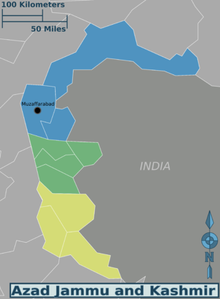
Azad Jammu and Kashmir abbreviated as AJK and colloquially referred to as simply Azad Kashmir, is a region administered by Pakistan as a nominally self-governing entity and constituting the western portion of the larger Kashmir region, which has been the subject of a dispute between India and Pakistan since 1947. Azad Kashmir also shares borders with the Pakistani provinces of Punjab and Khyber Pakhtunkhwa to the south and west, respectively. On its eastern side, Azad Kashmir is separated from the Indian union territory of Jammu and Kashmir by the Line of Control (LoC), which serves as the de facto border between the Indian- and Pakistani-controlled parts of Kashmir. Geographically, it covers a total area of 13,297 km2 (5,134 sq mi) and has a total population of 4,045,366 as per the 2017 national census.

The Pulwama district is an administrative district of Indian-administered Jammu and Kashmir in the disputed Kashmir region. It is located to the south of Srinagar. Its district headquarters are situated in the city of Pulwama. It is located in the central part of the Kashmir Valley.
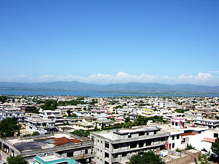
Mirpur, officially known as New Mirpur City, is the capital of Mirpur district located in Azad Kashmir, Pakistan which has been subject of the larger Kashmir dispute between Pakistan and India since 1947. It is the second largest city of Azad Kashmir and the 74th largest city in Pakistan.

Bhimber District is a district of Pakistan-administered Azad Kashmir in the disputed Kashmir region. It is the southernmost of the 10 districts of Pakistan's territory of Azad Kashmir. It has an area of 1,516 km², and the district headquarter is the town of Bhimber.

Kotli District is a district of Pakistan-administered Azad Kashmir in the Azad Kashmir region. It is one of the 10 districts of Pakistan's dependent territory of Azad Kashmir. It is bounded on the north by the Sudhanoti District and the Poonch District, on the north-east by the Poonch District of Indian-administered Jammu and Kashmir, on the south by the Mirpur and Bhimber districts, and on the west by the Rawalpindi District on Pakistan's Punjab Province. Kotli is the biggest district of Azad Kashmir by population and the second biggest by land area, after the Neelum District. The district headquarters is the city of Kotli. The main native languages are Pahari, and Gujari.

Mirpur District is a district of Pakistan-administered Azad Kashmir in the disputed Kashmir region. It is one of the 10 districts of Pakistan's territory of Azad Kashmir. The Mirpur District is bounded on the north by the Kotli District, on the east by the Bhimber District, on the south by the Gujrat District of Punjab, Pakistan, on the south-west by the Jhelum District of Punjab, Pakistan, and on the west by its Rawalpindi District. The district is named after its main city, Mirpur. The Mirpur District has a population of 456,200 and covers an area of 1,010 km2 (390 sq mi). The district is mainly mountainous with some plains. The Mirpur District has a humid subtropical climate which closely resembles that of the Gujrat District and the Jhelum District, the adjoining districts of Pakistan's Punjab Province.

Doda district is an administrative district of the Jammu division of Indian-administered Jammu and Kashmir in the disputed Kashmir region.
Jammudistrict is an administrative district of the Jammu division of Indian-administered Jammu and Kashmir in the disputed Kashmir region. It is the most populous district in the Jammu division.

Poonch or Punch is a district of the Jammu division of Indian-administered Jammu and Kashmir in the disputed Kashmir region. With headquarters in the town of Poonch, it is bounded by the Line of Control on three sides. The 1947-48 war between India and Pakistan divided the earlier district into two parts. One went to Pakistan and the other became part of the then-Indian state of Jammu and Kashmir.
The Gilgit District is one of the 14 districts of Pakistan-administered territory of Gilgit-Baltistan in the disputed Kashmir region. The headquarters of the district is the town of Gilgit. At the 1998 census, the Gilgit District had a population of 243,324. The district includes Gilgit, the Bagrot Valley, Juglot, Danyore, Sultanabad, Naltar Peak, and the Nomal Valley. The highest peak in the district is Distaghil Sar 7,885 metres (25,869 ft), which is the seventh-highest peak in Pakistan and 19th highest in the world.

Rajouri is a district in the Jammu division of Indian-administered Jammu and Kashmir in the disputed Kashmir region. The Line of Control, between the Indian- and Pakistani-administered Jammu and Kashmir, lies to its west, Poonch to its north, the Reasi district to the east and the Jammu district to its south. Rajouri is famous for its "Kalari". Representing an ancient principality, Rajouri was a joint district, along with Reasi, at the time of princely state's accession to India in 1947. The two tehsils were separated and Rajouri was merged with the Poonch district. Rajouri again became a separate district along with Reasi in 1968 till 2006 when both were separated again. The Rajouri district comprises 13 tehsils (boroughs). The land is mostly fertile and mountainous. Maize, wheat and rice are the main crops of the area and the main source of the irrigation is the river Tawi that originates from the mountains of Pir Panjal.
Nowshera is a town and the headquarters of an eponymous tehsil of Rajouri district in the Jammu division of the Indian Union Territory of Jammu and Kashmir. It is governed by a Municipal committee and in rural area of Nowshera consists of 14 panchayats governed by local bodies under the supervision of district administration Rajouri.

Bhimber is a town and the headquarters of the eponymous district in Pakistan-administered Azad Kashmir. The town and district are between the Jammu region of Indian-administered Kashmir and Pakistan proper, about 47 km (29 mi) by road southeast of Mirpur.

Reasi district is an administrative district in the Jammu division of Indian state of Jammu and Kashmir in the Jammu region. The Reasi district is bordered by Udhampur district and Ramban district in the east, Jammu district in the south, Rajouri district in the west and by Kulgam district on the north. The Reasi and Rajouri tehsils formed a joint district called the "Reasi district" at the time of the princely state's accession to India in 1947. As part of the reorganisation, the two tehsils were separated and Reasi was merged with the Udhampur district. It again became a separate district in 2006.

Samba district is an administrative district in the Jammu division of Indian-administered Jammu and Kashmir in the disputed Kashmir region. It was formed in 2006. Before its formation, this area was part of Jammu district and Kathua district.

Poonch District was a district of the princely state of Jammu and Kashmir, which is currently divided between India and Pakistan. The Pakistani part of the erstwhile district is now the Poonch Division in the Azad Kashmir territory, whilst the Indian part of the district is the Poonch district in Jammu and Kashmir. The capital of the Pakistan-controlled side is Rawalakot; while the capital of the Indian-controlled side is Poonch.

Jammu and Kashmir, also known as Kashmir and Jammu, was a princely state in a subsidiary alliance with the British East India Company from 1846 to 1858 and under the paramountcy of the British Crown, from 1858 until the Partition of India in 1947, when it became a disputed territory, now administered by three countries: China, India, and Pakistan. The princely state was created after the First Anglo-Sikh War, when the East India Company, which had annexed the Kashmir Valley, from the Sikhs as war indemnity, then sold it to the Raja of Jammu, Gulab Singh, for rupees 75 lakhs.

Kishtwar district is an administrative district of the Jammu division of Indian-administered Jammu and Kashmir in the Jammu Division. As of 2011, it is the largest and the least populous district of Jammu and Kashmir.

The Mirpur Division is a first-order administrative division of the Pakistani dependent territory of Azad Kashmir. Mirpur is the largest division by population in Azad Kashmir. It comprises the portion of the former Mirpur District of the princely state of Jammu and Kashmir that came under Pakistani control at the end of the Indo-Pakistani War of 1947.
In spring 1947, an uprising against the Maharaja Hari Singh of Jammu and Kashmir broke out in the Poonch jagir, an area bordering the Rawalpindi district of West Punjab and the Hazara district of the North-West Frontier Province in the future Pakistan. It was driven by grievances such as high taxes, the Maharaja's neglect of World War veterans, and above all, Muslim nationalism with a desire to join Pakistan. The leader of the rebellion, Sardar Muhammad Ibrahim Khan, escaped to Lahore by the end of August 1947 and persuaded the Pakistani authorities to back the rebellion. In addition to the backing, Prime Minister Liaquat Ali Khan authorised an invasion of the state, by the ex-Indian National Army personnel in the south and a force led by Major Khurshid Anwar in the north. These invasions eventually led to the First Kashmir War fought between India and Pakistan, and the formation of Azad Kashmir provisional government. The Poonch jagir has since been divided across Azad Kashmir, administered by Pakistan and the state of Jammu and Kashmir, administered by India.
| | This Azad Kashmir location article is a stub. You can help Wikipedia by expanding it. |