Mitterskirchen

Last updated
Mitterskirchen
Wappen von Mitterskirchen.png
Coat of arms
Location of Mitterskirchen within Rottal-Inn district
Mitterskirchen in PAN.svg
Germany adm location map.svg
Red pog.svg
Mitterskirchen
Bavaria location map.svg
Red pog.svg
Mitterskirchen
Coordinates: 48°21′N12°44′E / 48.350°N 12.733°E / 48.350; 12.733 Coordinates: 48°21′N12°44′E / 48.350°N 12.733°E / 48.350; 12.733
Country Germany
State Bavaria
Admin. region Niederbayern
District Rottal-Inn
Government
   Mayor (202026) Christian Müllinger [1]
Area
  Total24.77 km2 (9.56 sq mi)
Elevation
433 m (1,421 ft)
Population
 (2020-12-31) [2]
  Total2,163
  Density87/km2 (230/sq mi)
Time zone UTC+01:00 (CET)
  Summer (DST) UTC+02:00 (CEST)
Postal codes
84335
Dialling codes 08725
Vehicle registration PAN, EG
Website www.mitterskirchen.de

Mitterskirchen is a municipality in the district of Rottal-Inn in Bavaria in Germany.

Contents

Geography

Mitterskirchen is situated in a small side-valley of the Rott, bordering on the district of Oberbayern (upper Bavaria). Mitterskirchen is at the federal highway B588, about seven kilometers south-west of Eggenfelden, 18 kilometers north of Altötting, 23 kilometers north-east of Mühldorf, as well as 22 kilometers south-west of the district capital Pfarrkirchen. The next train station on the railway line Passau - Mühldorf is in Eggenfelden.

History

Mitterskirchen used to belong to the Rentamt  [ bar; de; es ] Landshut and the Landgericht (court) Eggenfelden of the Electorate Bavaria. The Freiin of Ingenheim, born a von Closen of Gern and Arnstorf, owned an open Hofmark here in 1800. During the administrative reforms in Bavaria, today's municipality was established by the 1818 Gemeindeedikt.

Development

In the municipality, 1.453 inhabitants were counted in 1970, then 1.612 in 1987 and 1.959 in the year 2000. The recent head count in 2007 is 2.068

Politics

The mayor is Christian Müllinger, first elected in 2014 and re-elected in 2020. [1]

Municipal tax revenue in 1999 was about 705.000 Euros, of which about 191.000 Euros were the net business tax revenue.

Economy and Infrastructure

Economy as well as Agriculture and forestry

In 1998, according to official statistics, there were 6 people employed in agriculture and forestry, 175 in production and 9 in commerce and traffic at this location. In other economic areas, 43 people were employed. There was a total of 661 employees at this place of residence. There were two businesses in the processing sector, six in construction. Furthermore, there were 87 farms in 1999 with an agriculturally-used area of 1,574 acres (6.37 km2) total, of which 998 acres (4.04 km2) were fields and 576 acres (2.33 km2) verdure.

Infrastructure

An extension of the federal highway from Eggenfelden to Altötting was finished in 2008, passing the village at a further distance now, and cutting through between the village's north-eastern limits and its adjacent neighborhood Leitenbach. The extension was necessary due to the bad condition of the original pieces of street that went through the village and the commuting traffic and heavy trucks.

Education

In 1999:

The school was extended with an additional building in 2004/2005.

Related Research Articles

Mühldorf is a Landkreis (district) in Upper Bavaria, Germany. It is bounded by the districts of Landshut, Rottal-Inn, Altötting, Traunstein, Rosenheim, Ebersberg and Erding.

Rottal-Inn is a Landkreis (district) in the southeastern part of Bavaria, Germany. Neighboring districts are Altötting, Mühldorf, Landshut, Dingolfing-Landau and Passau. To the southeast is the Austrian state Upper Austria (Braunau).

Geiselwind Place in Bavaria, Germany

Geiselwind is a market town in Lower Franconia (Bavaria) in the district of Kitzingen in Germany. It has a population of around 2,300.

Waldkraiburg Place in Bavaria, Germany

Waldkraiburg is a town in the district of Mühldorf, in Bavaria, Germany with a population of about 24,000. It is the biggest town in the district of Mühldorf. It is located on the river Inn, approximately ten kilometers southwest of Mühldorf and sixty kilometers east of Munich. Waldkraiburg is one of the Bavarian displaced person cities. During World War II, an armour factory fabricated gunpowder in this area. The remaining bunkers were soon used as makeshift housing for displaced persons from Sudetenland and Bohemia.

Eggenfelden Place in Bavaria, Germany

Eggenfelden is a municipality in the district of Rottal-Inn in Bavaria, Germany.

Burgkirchen an der Alz Place in Bavaria, Germany

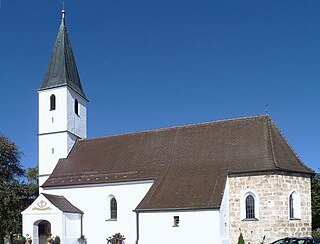
Burgkirchen an der Alz is a municipality in the district of Altötting, in Bavaria, Germany. It is situated on the river Alz, 8 km west of Burghausen.

Neumarkt-Sankt Veit Place in Bavaria, Germany

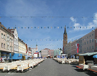
Neumarkt-Sankt Veit is a town in the district of Mühldorf, in Bavaria, Germany. It is located on the river Rott, 10 kilometers north of Mühldorf, and 33 kilometers southeast of Landshut.

Neuötting Place in Bavaria, Germany

Neuötting is a town in the district of Altötting, in Bavaria, Germany. It is situated on the river Inn, 2 km north of Altötting, about 70 km north of Salzburg, 80 southwest of Passau and almost 100 km east of Munich. It is a stop on the railway line between Munich and Simbach.

Erlbach, Bavaria Place in Bavaria, Germany

Erlbach is a municipality in the district of Altötting in Bavaria in Germany.

Teising Place in Bavaria, Germany

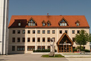
Teising is a municipality in the district of Altötting in Bavaria in Germany and belongs to the parish Burgkirchen am Wald. The village is located very centrally between the towns of Altötting and Mühldorf am Inn. Since 2008 most traffic is rerouted to the nearby freeway A94, which help the village center gain considerably in attractiveness.

Winhöring Place in Bavaria, Germany

Winhöring is a municipality in the district of Altötting in Bavaria in Germany. It lies on the river Inn.

Gundelsheim, Bavaria Place in Bavaria, Germany

Gundelsheim is a community in the Upper Franconian district of Bamberg.

Aßling Place in Bavaria, Germany

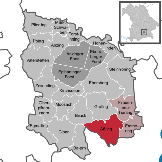
Aßling is a municipality in the district of Ebersberg, Upper Bavaria, Germany. It is, along with the communities of Emmering and Frauenneuharting, a member of the administrative community of the same name.

Egmating Place in Bavaria, Germany

Egmating is a community in the Upper Bavarian district of Ebersberg in Germany. It is a member of the administrative community (Verwaltungsgemeinschaft) of Glonn.

Ampfing Place in Bavaria, Germany

Ampfing is a municipality in the district of Mühldorf in Bavaria in Germany.

Haag in Oberbayern Place in Bavaria, Germany

Haag in Oberbayern is a municipality in the district of Mühldorf in Bavaria in Germany, in December 2013 the municipality had a population of 6359.

Schönberg, Upper Bavaria Place in Bavaria, Germany

Schönberg is a municipality in the district of Mühldorf in the Upper Bavaria region of Bavaria, Germany.

Zeilarn Place in Bavaria, Germany

Zeilarn is a municipality in the district of Rottal-Inn in Bavaria, Germany.

Gangkofen Place in Bavaria, Germany

Gangkofen is a municipality in the county ("Landkreis") of Rottal-Inn in Bavaria in Germany.

Frankenwinheim Place in Bavaria, Germany

Frankenwinheim is a village in the district of Schweinfurt in Bavaria, Germany and part of Verwaltungsgemeinschaft Gerolzhofen.

References

  1. 1 2 Liste der ersten Bürgermeister/Oberbürgermeister in kreisangehörigen Gemeinden, Bayerisches Landesamt für Statistik, 15 July 2021.
  2. "Tabellenblatt "Daten 2", Statistischer Bericht A1200C 202041 Einwohnerzahlen der Gemeinden, Kreise und Regierungsbezirke". Bayerisches Landesamt für Statistik und Datenverarbeitung (in German). June 2021.