
Ōtaki is a village located in Nagano Prefecture, Japan. As of 1 April 2019, the village had an estimated population of 753 in 378 household, and a population density of 2.4 persons per km². The total area of the village is 310.82 square kilometres (120.01 sq mi). At present, Ōtaki's land area is 95% forestland; 86% of which is designated national forest.

The McKenzie River is a 90-mile (145 km) tributary of the Willamette River in western Oregon in the United States. It drains part of the Cascade Range east of Eugene and flows westward into the southernmost end of the Willamette Valley. It is named for Donald McKenzie, a Scottish Canadian fur trader who explored parts of the Pacific Northwest for the Pacific Fur Company in the early 19th century. As of the 21st century, six large dams have been built on the McKenzie and its tributaries.

An underground power station is a type of hydroelectric power station constructed by excavating the major components from rock, rather than the more common surface-based construction methods.

Lake Vyrnwy is a reservoir in Powys, Wales, built in the 1880s for Liverpool Corporation Waterworks to supply Liverpool with fresh water. It flooded the head of the Vyrnwy valley and submerged the village of Llanwddyn.

Deerfield River is a river that runs for 76 miles (122 km) from southern Vermont through northwestern Massachusetts to the Connecticut River. The Deerfield River was historically influential in the settlement of western Franklin County, Massachusetts, and its namesake town. It is the Connecticut River's second-longest tributary in Massachusetts, 2.1 miles (3.4 km) shorter than Metropolitan Springfield's Westfield River.
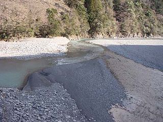
The Ōi River is a river in Shizuoka Prefecture, Japan.

The Shinano River, known as the Chikuma River in its upper reaches, is the longest and widest river in Japan and the third largest by basin area. It is located in northeastern Honshu, rising in the Japanese Alps and flowing generally northeast through Nagano and Niigata Prefectures before emptying into the Sea of Japan.
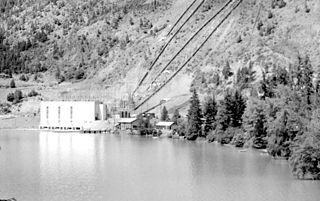
The Bridge River Power Project is a hydroelectric power development in the Canadian province of British Columbia, located in the Lillooet Country between Whistler and Lillooet. It harnesses the power of the Bridge River, a tributary of the Fraser, by diverting it through a mountainside to the separate drainage basin of Seton Lake, utilizing a system of three dams, four powerhouses and a canal.

Lake Almanor is a large reservoir in northwestern Plumas County, northeastern California, United States. The reservoir has a capacity of 1,308,000 acre-feet (1.613×10⁹ m3) and a maximum depth of about 90 feet (27 meters). It is formed by Canyon Dam on the North Fork of the Feather River, as well as Benner and Last Chance Creeks, Hamilton Branch, and various natural springs.

The Tenryū River is a river in central Honshū, Japan. With a length of 213 km (132 mi), it is Japan's ninth longest river.

The Tateyama Kurobe Alpine Route is a mountain sightseeing route between Tateyama, Toyama and Ōmachi, Nagano, Japan. Opened on June 1, 1971, it is 37 kilometres long, with a difference in elevation of as much as 1,975 metres.
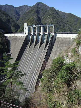
The Sakuma Dam is a dam on the Tenryū River, located on the border of Toyone, Kitashitara District, Aichi Prefecture on the island of Honshū, Japan. It is one of the tallest dams in Japan and supports a 350 MW hydroelectric power station. Nearby a frequency converter station is installed, allowing interchange of power between Japan's 50 Hz and 60 Hz AC networks.
Asahi Dam (朝日ダム) is a dam built on the class 1 Hida River, located in the city of Takayama, Gifu Prefecture, Japan.
Ocoee Dam No. 3 is a hydroelectric dam on the Ocoee River in Polk County, in the U.S. state of Tennessee. It is one of four dams on the Toccoa/Ocoee River owned and operated by the Tennessee Valley Authority, which built the dam in the early 1940s to meet emergency demands for electricity during World War II. The dam impounds the 360-acre (150 ha) Ocoee No. 3 Reservoir, which stretches 11 miles (18 km) upriver to the Tennessee-Georgia state line. Ocoee No. 3's powerhouse is actually located several miles downstream from the dam, and is fed by a 2.5-mile (4.0 km) conduit that carries water to it from the reservoir.

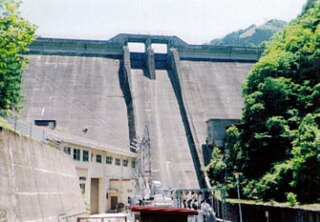
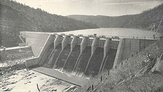
The Tashiro Dam is a dam on the Ōi River in Aoi-ku, Shizuoka, Shizuoka Prefecture on the island of Honshū, Japan. It was the first concrete gravity dam to be constructed on the Ōi River, and has a hydroelectric power generating station owned by the Tokyo Electric Power Company.
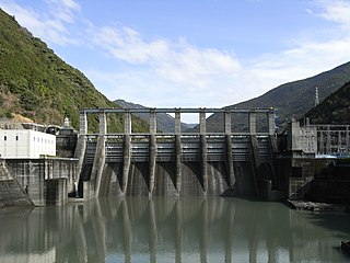
The Akiba Dam is a dam on the Tenryū River, located in Tenryū-ku, Hamamatsu, Shizuoka Prefecture on the island of Honshū, Japan.

The North Fork Kings River is a 40.3-mile (64.9 km) tributary of the Kings River, in the U.S. state of California. The river's main stem is entirely within Fresno County, and its watershed drains about 387 square miles (1,000 km2) of the southern Sierra Nevada mountain range.

The Shin-Takasegawa Pumped Storage Station (新高瀬川発電所) uses the Takase River to operate a pumped storage hydroelectric scheme about 12 kilometres (7.5 mi) west of Ōmachi in Nagano Prefecture, Japan. Part of the system is within Chūbu-Sangaku National Park.

Futai Dam (二居ダム) is a dam in Yuzawa, Niigata Prefecture, Japan, completed in 1978.
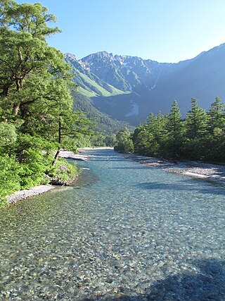
The Azusa River is a river within the Hida Mountains or Northern Japanese Alps, in the western region of Nagano Prefecture, Japan. The river belongs to the Shinano River watershed, and forms the upper section of the Sai River. The name of the river comes from the catalpa tree found in the river basin, which are used for Azusa Yumi, a sacred bow in Shinto rituals. The river gives its name to the Azusa limited express train, which is operated by the East Japan Railway Company, and which runs mainly between Shinjuku Station in Tokyo and Matsumoto Station in Nagano.
