
Tanygrisiau is a village and area within Blaenau Ffestiniog in the upper end of the Vale of Ffestiniog in the county of Gwynedd, north-west Wales. It can be found along the southern side of the Moelwyn mountain range and dates to around 1750. It joins onto the semi-urban area of Blaenau Ffestiniog, and is in the community of Ffestiniog; located between 650 feet (200 m) and 750 feet (230 m) above sea level. it is in the electoral ward of Bowydd and Rhiw which had a 2011 census population of 1878. The village itself has a population of around 350.

Moel Hebog is a mountain in Snowdonia, north Wales which dominates the view west from the village of Beddgelert. It gives name to a whole range of peaks in the north-western corner of Snowdonia, which include the Nantlle Ridge and Mynydd Mawr.

The River Dwyryd is a river in Gwynedd, Wales which flows principally westwards; draining to the sea into Tremadog Bay, south of Porthmadog.

Moelwyn Mawr is a mountain in Snowdonia, North Wales and forms part of the Moelwynion. Its summit overlooks the Vale of Ffestiniog and has views in all directions.
Moelwyn Bach is a mountain in Snowdonia, northern Wales and forms part of the Moelwynion. It is connected to its parent peak Moelwyn Mawr via the Craigysgafn ridge.

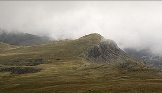
Craigysgafn is a rocky ridge and a top of Moelwyn Mawr that leads south from Moelwyn Mawr to Moelwyn Bach in Snowdonia, North Wales. It has several gullies which lead directly down to the scree slopes above Llyn Stwlan. Some scrambling is needed in places.
Moel-yr-hydd is a subsidiary summit of Moelwyn Mawr in Snowdonia, North Wales and forms part of the Moelwynion.

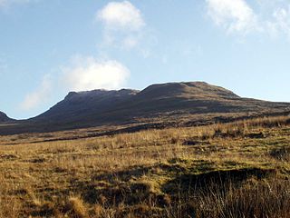
Manod Mawr is a mountain in North Wales and forms part of the Moelwynion. Although known as a mountain in the eastern Moelwyns, it and its sister peaks are sometimes known as the Ffestiniog hills.

The Moelwynion are a group of mountains in central Snowdonia. They extend from the north-east of Porthmadog to Moel Siabod, the highest of the group. The name derives from the names of two of the largest mountains in the group, Moelwyn Mawr and Moelwyn Bach, 770m and 710m, respectively. Moel Siabod, to the north, is the highest at 872m.

Mynydd Mawr is a mountain in Snowdonia, North Wales, approximately 7 km (4.3 mi) west of Snowdon itself, overlooking Llyn Cwellyn and being the northern outlier of the Moel Hebog group. A popular ascent starts from Rhyd Ddu. On its western flank are the remains of ancient settlements and field systems. The profile of Mynydd Mawr from the north is often thought to resemble an elephant lying down, and consequently the mountain is often colloquially also called "Yr Eliffant", or "Elephant Mountain" by non-Welsh speakers.
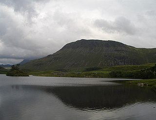
Tyrrau Mawr or Craig-las is a subsidiary summit of Cadair Idris in the Snowdonia National Park, in Gwynedd, northwest Wales. It lies to the west of Cyfrwy, and can be climbed by taking a west bearing from the Pony Path at Rhiw Gwredydd. Its north face is a crag, known as Craig-las. Below the crags lies Llyn Cregennen with its small island. The reflection of Craig-las from this lake is one of the famous images associated with Snowdonia.
Cyfrwy is a subsidiary summit of Cadair Idris in the Snowdonia National Park, in Gwynedd, northwest Wales. It lies to the west of Cadair Idris and is often climbed with Cadair Idris by taking the Pony Path.

Bera Bach is a summit, height 807 metres, in the Carneddau mountains in north Wales. It is part of a ridge leading west from Garnedd Uchaf. The summit is a rocky tor, characteristic of the northern Carneddau. Bera Mawr and Bera Bach are together known as the Berau, meaning 'ricks' or 'stacks'. They are both excellent examples of the area's tors. To the west, the ridge continues to Drosgl. Despite Bach in Welsh meaning small, it is higher than Bera Mawr.

Manod Mawr North Top is a mountain in North Wales and forms part of the Moelwynion.

Craig-y-llyn is a subsidiary summit of Cadair Idris in the Snowdonia National Park, in Gwynedd, northwest Wales. It lies at the western end of the long Cadair Idris ridge. Its north-facing cwm houses the small glacial lake, Llyn Cyri. The southern flanks have gentle slopes, while the northern are very steep and contain broken crags.

Pen Twyn Mawr is a top of Pen y Gadair Fawr in the Black Mountains in south-eastern Wales. It lies on one of the many south ridges of Waun Fach.

Y Ro Wen is a mountain just north of Blaenau Ffestiniog, North Wales and forms part of the Moelwynion.

Y Gamallt is a mountain located in the Migneint in Snowdonia, North Wales. It forms part of the Arenig mountain range being separated from the Moelwynion range at the head of Cwm Teigl.

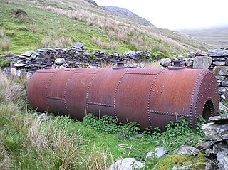
Moelwyn quarry is a defunct slate quarry located to the south of the village of Tanygrisiau, north Wales. Some initial prospecting was carried out in the 1820s and again in the 1840s, but it was 1860 before a company was formed, and chambers were excavated. The quarry was never a financial success, and operated sporadically until its demise in 1897. Despite the poor results, a spectacular series of seven inclines were constructed, to enable slates to reach the Ffestiniog Railway. The quarry was hampered by lack of a good water supply, and the mill was constructed between inclines 4 and 5, where water could be obtained from Llyn Stwlan. As in many quarries, barracks were provided, but these were occupied by whole families, living on the mountain, rather than used as lodgings for the quarrymen during the working week. Even in its remote location, there was still a concern for education, with basic literacy classes being run in the 1860s.
Fron-Boeth and Pant Mawr quarries were two closely related and interconnected quarries on the western slopes of Moelwyn Mawr in Gwynedd, North Wales. Pant Mawr operated from around 1850 to 1879, and was partly re-opened in 1886 when it was amalgamated with Fron-Boeth. Both quarries closed during the First World War. Finished product was transported to the slate quays of Porthmadog by the Croesor Tramway.
