
Otsego County is a county in the U.S. state of New York. As of the 2010 census, the population was 62,259. The county seat is Cooperstown. The name Otsego is from a Mohawk or Oneida word meaning "place of the rock."
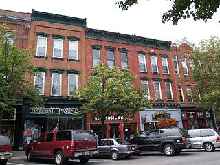
Cooperstown is a village in and county seat of Otsego County, New York, United States. Most of the village lies within the town of Otsego, but some of the eastern part is in the town of Middlefield. It is located at the southern end of the historic Otsego Lake and is in the Central New York Region of New York.

Otsego is a town in the north-central part of Otsego County, New York, United States. The population was 3,900 at the 2010 census. The town is named after Lake Otsego, which forms part of the town's eastern border.

Otsego Lake is a 4,046-acre (16.37 km2) lake located in Otsego County in the U.S. State of New York. It is the source of the Susquehanna River and largest lake in Otsego County. The Village of Cooperstown is located at the lake's southern end. Glimmerglass State Park is located on the lake's northeastern shore, and includes Hyde Hall, a large mansion constructed in 1817 that overlooks the lake. Glimmerglass Opera is located on the western shore.

The Leatherstocking Tales is a series of five novels by American writer James Fenimore Cooper, set in the eighteenth century era of development in the primarily former Iroquois areas in central New York. Each novel features Natty Bumppo, a frontiersman known to European-American settlers as "Leatherstocking", "The Pathfinder", and "the trapper". Native Americans call him "Deerslayer", "La Longue Carabine", and "Hawkeye".

Five Mile Point is a geographic cape extending into Otsego Lake in the Town of Otsego north of Cooperstown, New York. Mohican Brook enters Otsego Lake at Five Mile Point.
Willow Brook is a river in Otsego County, New York. It drains out of Moe Pond, flows through Cooperstown, and empties into Otsego Lake.

Leatherstocking Creek is a small creek in central Otsego County, New York. It begins northwest of Pierstown and flows southeast then south before flowing into Otsego Lake north of Cooperstown, and just south of Three Mile Point.
Shadow Brook, also known as East Springfield Brook, is a river in northern Otsego County in the U.S. State of New York. It begins north-northeast of the Hamlet of East Springfield, and flows into Otsego Lake south-southeast of the Hamlet of Springfield Center, near Glimmerglass State Park. It is the largest watershed in the Otsego Lake basin.

Mount Wellington is a mountain located in the Central New York Region of New York. It is located south of the Hamlet of Springfield Center at the northern end of Otsego Lake. Mount Wellington rises 600 feet (180 m) above lake level. The extreme southern point of the mountain is called Clarke Point and also referred to as the Shad Cam. It is known as "The Sleeping Lion", as it looks similar to a lion laying down, viewed from Cooperstown, New York. It was originally named Mount Millington, but was renamed by George Hyde Clarke in honor of the Duke of Wellington, the victor of Waterloo, who had been Clarke's schoolmate at Eton College in England.
Red House Hill is a mountain in the Central New York Region of New York. It is located south-southwest of the Hamlet of Springfield Center, New York, west of Hutter Point and Six Mile Point of Otsego Lake, and southeast of Rum Hill. Mohican Brook flows eastward along the southern edge of the hill.

Pierstown is a hamlet located on CR-28 north of Cooperstown and west of Five Mile Point in the Town of Otsego, in Otsego County, New York, United States.
Three Mile Point also known as Wild Rose Point is a geographic cape extending into Otsego Lake in the Town of Otsego in Otsego County in the U.S. State of New York. It is located north of the Village of Cooperstown and is accessible via State Route 80. In the summer months it is also a public swimming beach and offers changing rooms, a picnic area, and a pavilion. In the winter months it serves as a place for ice fishers to park.
Hutter Point is a geographic cape extending into Otsego Lake in the Town of Otsego north of Cooperstown, New York. Hutter Point is where Deerslayer first saw the "Glimmerglass".
Six Mile Point also known as Hickory Grove is a geographic cape extending into Otsego Lake in the Town of Otsego north of Cooperstown, New York. Six Mile Point is the location in The Deerslayer that Natty Bumppo makes an unsuccessful effort to escape from the Hurons.

Point Judith also known as Kingfisher Point is a geographic cape extending into Otsego Lake in the Town of Otsego north of Cooperstown, New York. Kingfisher Tower is located on the lake off Point Judith.
Gravelly Point is a geographic cape extending into Otsego Lake in the Town of Middlefield in Otsego County in the U.S. State of New York. It is located on the east side of the lake, roughly 5 miles (8.0 km) north of the Village of Cooperstown. The point is not accessible from land but only the lake.
Peggs Point is a geographic cape extending into Otsego Lake in the Town of Middlefield in Otsego County in the U.S. State of New York. It is located on the east shore of the lake north of the Village of Cooperstown. The point forms the southern edge of Hyde Bay which is located north.
Brookwood Creek is a creek in central Otsego County, New York. It flows into Otsego Lake north of Cooperstown, New York at Brookwood Point.
Glimmer Glen Creek is a creek in central Otsego County, New York. It flows into Otsego Lake north of Cooperstown, New York and south of Brookwood Point.

