
The Australian First Tactical Air Force was formed on 25 October 1944 by the Royal Australian Air Force (RAAF). Its purpose was to provide a mobile force of fighter and ground attack aircraft that could support Allied army and naval units fighting the Empire of Japan in the South West Pacific Area. One of several Allied tactical air forces formed during World War II, it evolved from the RAAF's No. 10 Operational Group, established a year earlier. Following action in the assaults on Aitape and Noemfoor, the group was renamed the First Tactical Air Force to better reflect its size and role. It was beset with morale and leadership issues in early 1945, but recovered to take part in the battles of Tarakan, North Borneo, and Balikpapan. Reaching its peak strength of over 25,000 personnel in July 1945, No. 1 TAF's squadrons operated such aircraft as the P-40 Kittyhawk, Supermarine Spitfire, Bristol Beaufighter, and B-24 Liberator. The formation remained active following the end of hostilities in the Pacific until it was disbanded on 24 July 1946.

RAAF Base Townsville is a Royal Australian Air Force (RAAF) air base located in Garbutt, 2 nautical miles west of Townsville in Queensland, Australia. It is the headquarters for No. 1 Wing Australian Air Force Cadets and, along with Lavarack Barracks, establishes Townsville as a key military centre. The base's airfield is shared with the Townsville Airport.

Madang Airport, is an airport located in Madang, Papua New Guinea.
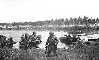
The Admiralty Islands campaign was a series of battles in the New Guinea campaign of World War II in which the United States Army's 1st Cavalry Division took the Japanese-held Admiralty Islands.

Gurney Airport is an airport serving Alotau in the Milne Bay Province of Papua New Guinea (PNG).
Losuia Airport is an airport in Losuia, on the island of Kiriwina, Papua New Guinea.

Los Negros Island is the third largest of the Admiralty Islands. It is significant because it contains the main airport of Manus Province on its eastern coastline, at Momote. It is connected to Lorengau, the capital of the province, on Manus Island via a highway and bridge across the Lonui Passage, which separates Los Negros from the larger Manus Island.

Fenton Airfield was a World War II military airfield in the Northern Territory of Australia located at Tipperary Station in what is now the locality of Douglas-Daly and named after flight lieutenant Clyde Fenton.
Aitkenvale Aerodrome was an aerodrome located 10 km (6 mi) southwest of Townsville, Queensland, Australia near Aitkenvale Weir on the banks of the Ross River. It was also known as Weir and Aitkenvale Weir.
Bohle River Aerodrome was an aerodrome located 12.66 km (7.87 mi) west of Townsville, Queensland, Australia.
Mokerang Airfield, was an airfield on the northwest tip of Los Negros Island, 5 miles (8.0 km) NNW of Momote Airfield.

Taranto-Grottaglie "Marcello Arlotta" Airport is an airport serving Taranto and Grottaglie, both comunes in the province of Taranto in Italy. The airport is located 1.5 kilometres (0.9 mi) from the city of Monteiasi, 4 km (2.5 mi) from Grottaglie and 16 km (9.9 mi) from Taranto. It is named for Marcello Arlotta (1886–1918), an Italian aviator.

No. 73 Wing was a Royal Australian Air Force (RAAF) wing of World War II. It was formed in February 1943 at Port Moresby, Papua New Guinea, as part of No. 9 Operational Group. The wing initially comprised three attack squadrons flying CAC Wirraways, Douglas Bostons, and Bristol Beaufighters, with which it took part in the New Guinea campaign until mid-year. It was then reorganised with three fighter squadrons operating P-40 Kittyhawks and Supermarine Spitfires; in this form it saw action in the New Britain and Admiralty Islands campaigns through 1943–44. The wing was disbanded at Los Negros in August 1944, and by the beginning of 1945 its squadrons had been absorbed into other RAAF wings under No. 10 Operational Group.

Kerevat Airfield was an aerodrome located near Kerevat, East New Britain province, Papua New Guinea. Situated on the northern coast, it was 13 miles (21 km) south west of Rabaul. The airfield was constructed by the Imperial Japanese in World War II during September 1943. Kerevat Airfield was neutralized by Allied Powers' air bombing from 1944, who ran missions on the airfield between June 20, 1943, and May 16, 1944. The airfield was abandoned after the cessation of hostilities; however, the airstrip is still visible.
Lombrum Naval Base, also known as HMPNGS Tarangau and formerly PNG Defence Force Base Lombrum, is a naval military base operated by the Maritime Operations Element of the Papua New Guinea Defence Force (PNGDF). It is located on Manus Island in Papua New Guinea. Lombrum is the home port of the PNGDF's Pacific-class patrol boat force.

Palikulo Bay Airfield or Bomber Field #1 is a former World War II airfield on the island of Espiritu Santo in the New Hebrides Islands at the Espiritu Santo Naval Base.

Nanumea Airfield is a former World War II airfield on the island of Nanumea in the Ellice Islands.
Ondonga Airfield is a former World War II airfield on New Georgia in the Solomon Islands archipelago.
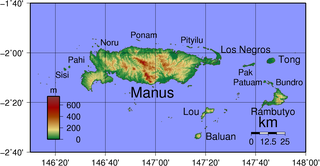
Manus Naval Base was a number of bases built after the World War II Battle of Manus by United States Navy on the Manus Island and a smaller island just east, Los Negros Island in the Admiralty Islands chain. The major naval base construction started with the Los Negros landings on February 28, 1944. The Navy repaired and did the expansion of the airfields on the Admiralty Islands. United States Navy Seabee built or repaired the facilities on the islands. The large Manus Naval Base, also called the Admiralty Island base, supported United States Seventh Fleet, Southwest Pacific command, and part of the Pacific Fleet. The base was abandoned by the US Navy after the war.

Naval Base Merauke was a United States Navy base built during World War II at city of Merauke in the South Papua province of Indonesia, then Dutch New Guinea. The base was 2 miles from the mouth of the Merauke River. The US Navy built a PT boat base and base dock with anchorage to support the Pacific War and the New Guinea campaign.


