
Franklin County is a county located in South Central Pennsylvania. As of the 2020 census, the population was 155,932 Its county seat is Chambersburg.

Michaux State Forest is a Pennsylvania State Forest in Pennsylvania Bureau of Forestry District #1. The main offices are located in Fayetteville in Franklin County, Pennsylvania, USA.

Caledonia State Park is a 1,125-acre (455 ha) Pennsylvania state park in Greene Township, Franklin County and Franklin Township, Adams County in southern Pennsylvania.
The Bellefonte Central Railroad was a shortline connecting Bellefonte and State College, Pennsylvania. Constructed in the late 19th century to haul local iron ore to furnaces in the Bellefonte region, it later hauled freight traffic to Penn State and lime for steelmaking from local quarries. The line to State College was abandoned in 1974, and most of the remaining railroad in 1984, but a small portion is still used by the Nittany and Bald Eagle Railroad.
The Catasauqua and Fogelsville Railroad was built in the 1850s to transport iron ore from local mines in Lehigh and later Berks County to furnaces along the Lehigh River in eastern Pennsylvania. Originally owned by two iron companies, the railroad later became part of the Reading system, and parts of it remain in operation today.
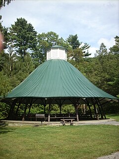
Mont Alto State Park is a Pennsylvania state park on 24 acres (9.7 ha) in Quincy Township, Franklin County, Pennsylvania in the United States. The park is on Pennsylvania Route 233 one mile from Mont Alto.
Big Spring State Park is a 45-acre (18 ha) Pennsylvania state park in Toboyne Township, Perry County, Pennsylvania in the United States. The park is on Pennsylvania Route 274, 5.5 miles (8.9 km) southwest of New Germantown. Big Spring State Park is a hiking and picnic area. A partially completed railroad tunnel in Conococheague Mountain is a feature of the park.
The Lurgan Subdivision is a railroad line owned and operated by CSX Transportation in the U.S. states of Pennsylvania, Maryland, and West Virginia. The line runs from Chambersburg, Pennsylvania, south to Hagerstown, Maryland, and west to Cherry Run, West Virginia, along a former Western Maryland Railway line. It meets the Hanover Subdivision at Hagerstown and the Cumberland Subdivision at Cherry Run. The line is named after its former northern end in Lurgan Township, Franklin County, Pennsylvania, where the Western Maryland once connected to the Reading Company along the Alphabet Route.
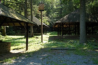
Pine Grove Furnace State Park is a protected Pennsylvania area that includes Laurel and Fuller Lakes in Cooke Township of Cumberland County. The Park accommodates various outdoor recreation activities, protects the remains of the Pine Grove Iron Works (1764), and was the site of Laurel Forge (1830), Pine Grove Park (1880s), and a brick plant (1892). The Park is 8 miles (13 km) from exit 37 of Interstate 81 on Pennsylvania Route 233.
The Bellefonte and Snow Shoe Railroad was a coal-hauling railroad in Centre County, Pennsylvania. Begun in 1859, it came under the control of the Pennsylvania Railroad in 1881. Closing of mines in the 1930s resulted in the decline of traffic on the railroad, which was abandoned in 1959.

The Maryland Mining Company is a historic coal mining, iron producer and railroad company that operated in Allegany County, Maryland, United States.
The Georges Creek Railroad was a railroad operated by the Georges Creek Coal and Iron Company in Western Maryland. The railroad operated from 1853 to 1863, when it was acquired by the Cumberland and Pennsylvania Railroad (C&P).

Pennsylvania Route 233 is a 53-mile-long (85 km) north–south state highway in south central Pennsylvania. It runs from PA 997 in Mont Alto north to PA 274 in Green Park. PA 233 heads northeast from Mont Alto through forested areas in the South Mountain range, where it runs through Mont Alto and Caledonia state parks and has an intersection with U.S. Route 30. After heading northwest out of the mountains, the route continues into the agricultural Cumberland Valley, where it intersects Interstate 81 (I-81) and US 11 and crosses PA 641 in Newville. PA 233 crosses Blue Mountain into Perry County near Colonel Denning State Park and continues northeast to Landisburg, where it intersects PA 850 and turns north to continue to its terminus.
The Hagerstown & Frederick Railway, now defunct, was an American railroad of central Maryland built in the 19th and 20th centuries.
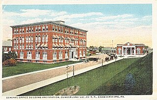
The Cumberland Valley Railroad was an early railroad in Pennsylvania, United States, originally chartered in 1831 to connect with Pennsylvania's Main Line of Public Works. Freight and passenger service in the Cumberland Valley in south central Pennsylvania from near Harrisburg to Chambersburg began in 1837, with service later extended to Hagerstown, Maryland, and then extending into the Shenandoah Valley to Winchester, Virginia. It employed up to 1,800 workers.

Pennsylvania Route 997 is a 49.0-mile (78.9 km) route in Franklin and Cumberland counties in central Pennsylvania. The route runs from the Maryland state line south of Waynesboro, where the road continues into that state as Maryland Route 64, north to PA 233 in the Upper Mifflin Township community of McCrea. PA 997 heads north from the state line through agricultural areas in the Cumberland Valley and passes through Waynesboro, where it intersects PA 16, and Mont Alto, where it intersects the south end of PA 233, before coming to U.S. Route 30 in Greenwood. From here, the route turns northwest and comes to a junction with Interstate 81 (I-81) and PA 696 near Scotland and US 11 in Green Village. PA 997 crosses PA 433 in Culbertson and heads north along the eastern border of Letterkenny Army Depot to Pleasant Hall, where it crosses PA 533. The route continues north through rural areas and intersects PA 433 near Lurgan and PA 641 in Roxbury before heading northeast and reaching an interchange with the Pennsylvania Turnpike (I-76) near Blue Mountain. PA 997 leaves Franklin County for Cumberland County and intersects the north end of PA 696 before continuing to McCrea.

The Ironton Railroad was a shortline railroad in Lehigh County, Pennsylvania. Originally built in 1861 to haul iron ore and limestone to blast furnaces along the Lehigh River, traffic later shifted to carrying Portland cement when local iron mining declined in the early 20th century. Much of the railroad had already been abandoned when it became part of Conrail in 1976, and the last of its trackage was removed in 1984.

The South Mountain Railroad was a southcentral Pennsylvania railway line for "connecting the Pine Grove works to the Cumberland Valley R. R." and which provided mining and passenger services via a southwest section from Hunter's Run, Pennsylvania, and a northern section from Hunter's Run to the CVRR junction northeast of Carlisle. The northern section merged with the Gettysburg & Harrisburg Railroad line south from Hunter's Run to the Gettysburg Battlefield in 1891 to create the Gettysburg & Harrisburg Railway line, while the branch southwest from Hunter's Run became the Hunter's Run and Slate Belt Railroad line.
The Hunter's Run and Slate Belt Railroad was a railway line from the Hunter's Run junction of the Gettysburg and Harrisburg Railway that ran southwestward along the south side of Mountain Creek to the Pine Grove Iron Works. The line serviced facilities for mining, for manufacturing, and for recreation. Portions of the railbed are a section of the Appalachian Trail as well as the majority of the Cumberland County Biker/Hiker Trail and the entire "Old Railroad Bed Road" that is the southeast border of Pine Grove Furnace State Park.
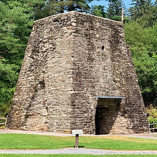
The Pine Grove Iron Works was a southcentral Pennsylvania smelting facility during the Industrial Revolution. The works is notable for remaining structures that are historical visitor attractions of Pine Grove Furnace State Park, including the furnace stack of the Pine Grove Furnace. The site was listed on the National Register of Historic Places on April 13, 1977 for its significance in architecture and industry. It includes seven contributing buildings, two structures, fourteen sites, and two objects.
