
The French Southern and Antarctic Lands is an overseas territory of France. It consists of:
- Adélie Land, the French claim on the continent of Antarctica.
- Crozet Islands, a group in the southern Indian Ocean, south of Madagascar.
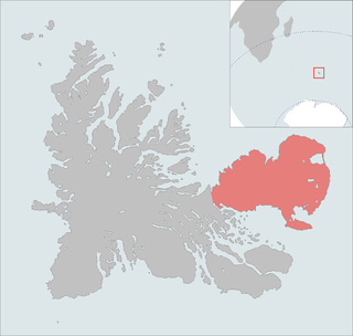
- Kerguelen Islands, a group of volcanic islands in the southern Indian Ocean, southeast of Africa.
- Saint Paul and Amsterdam Islands, a group to the north of the Kerguelen Islands.
- Scattered Islands, a dispersed group of islands around the coast of Madagascar.
The Kerguelen Islands, also known as the Desolation Islands, are a group of islands in the sub-Antarctic constituting one of the two exposed parts of the Kerguelen Plateau, a large igneous province mostly submerged in the southern Indian Ocean. They are among the most isolated places on Earth, located more than 3,300 kilometres from Madagascar. The islands, along with Adélie Land, the Crozet Islands, Amsterdam and Saint Paul islands, and France's Scattered Islands in the Indian Ocean, are part of the French Southern and Antarctic Lands and are administered as a separate district.
Avranches is a commune in the Manche department, and the region of Normandy, northwestern France. It is a subprefecture of the department. The inhabitants are called Avranchinais.

The Îlots des Apôtres or Îles des Apôtres are a group of small and uninhabited rocky islands in the north-western part of the Crozet Archipelago in the southern Indian Ocean, 10 km (6.2 mi) north of Île aux Cochons. Their total area is about 2 km2 (0.77 sq mi).

Mont Ross is a stratovolcano, the highest mountain in the Kerguelen Islands at 1,850 metres (6,070 ft). It is located in the Gallieni Massif, at the end of the Gallieni Peninsula, east of Baie Larose on the main island of Grande Terre. The volcano is composed primarily of trachybasalt and was active during the late Pleistocene. Eruptives have been dated between 2 million years to 100,000 years old.
The Courbet Peninsula is a peninsula in northeastern Grande Terre Island, the main island of the subantarctic Kerguelen Archipelago, Southern Indian Ocean. In the south of the peninsula is Port-aux-Français, the principal station of the archipelago.
The Kerguelen Islands are part of the Southern Indian Ocean Islands tundra ecoregion that includes several subantarctic islands. In this cold climate plant life is mainly limited to grasses, mosses and lichens, although the islands are also known for the indigenous edible Kerguelen cabbage. The islands are at the Antarctic convergence, where cold water moving up from the Antarctic mixes with the warmer water of the Indian Ocean. As a consequence, marine mammals, especially seals, and seabirds and penguins are numerous.

Gaspésie National Park is a provincial park located south of the town of Sainte-Anne-des-Monts, Quebec, Canada in the inland of the Gaspé peninsula. The park contains the highest peak of the Appalachian Mountains in Canada, Mont Jacques-Cartier, 1,270 metres (4,170 ft) above sea level. In addition, the park contains the only population of Caribou found south of the Saint Lawrence River in Canada.
Mount Aubert de la Rue is an ice-free hill, 125 metres (410 ft) high, standing at the south end and surmounting the low Fidelia Isthmus that connects Laurens Peninsula with the main mass of Heard Island. It was first charted and named by Edgar Aubert de la Rue, French geologist aboard the whale catcher of the island in January 1929, and later surveyed by the Australian National Antarctic Research Expeditions in 1948.
Mount Andree is an ice-free hill, 140 m, surmounting the small headland between Cave and West Bays on the west side of Heard Island. First charted and named by Edgar Aubert de la Rue, French geologist aboard the whale humper Kildalkey, who with his wife Andree undertook geological investigations along the north and west sides of the island in January 1929. The feature was determined to form part of a dissected volcanic crater by the British Australian New Zealand Antarctic Research Expedition (BANZARE), under Mawson, which visited the area in November 1929 and applied the name Cave Bay Hill. The approved name, a shortened form of Mont Andree de la Rue, was recommended by Antarctic Names Committee of Australia (ANCA) in 1954.

The Péninsule Loranchet, also known as Presqu'île Loranchet, is a peninsula of Grande Terre, the main island of the subantarctic Kerguelen archipelago in the southern Indian Ocean.

Edgar Aubert de la Rüe (1901–1991) was a French geographer, geologist, traveller and photographer who was primarily devoted to the islands of Saint Pierre and Miquelon, Kerguelen, and Vanuatu. Mount Aubert de la Rue on Heard Island is named after him.

The Mont-Saint-Michel Abbey is an abbey located within the city and island of Mont-Saint-Michel in Normandy, in the department of Manche.

Lac Marville is a lagoon in the Kerguelen islands, part of the French Southern and Antarctic Lands. Extending over approximately 27 km2 (10 sq mi), it is the largest lake in the archipelago and one of the largest in France.

The Gallieni Massif is a mountain range in Grande Terre, the main island of Kerguelen in the French Southern Territories zone of the Southern Indian Ocean.
Baie de l'Oiseau is a natural harbour in the Loranchet Peninsula, in the North-Western part of the island Grande Terre, part of the Kerguelen Islands. It was the landing site of the expedition under Yves de Kerguelen in 1772, and later of the expedition under James Cook in 1776. The site of Port-Christmas is part of the bay.
Baie de la Dauphine is a natural harbour located on the Loranchet Peninsula, at the north-west of the island of Grande Terre in the Kerguelen Islands.

Île aux Pigeons is a small uninhabited island located about 2 kilometres (1.2 mi) off the coast of Saint-Pierre and Miquelon, a self-governing territorial overseas collectivity of France and the last remaining part of New France in North America.
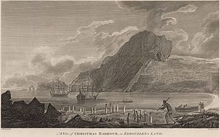
Port-Christmas is a natural and historical site on the Kerguelen Islands, located at the northern tip of the main island, on the east coast of the Loranchet Peninsula. It covers the bottom of Baie de l'Oiseau, the first shelter for sailors approaching the archipelago from the north, and is easily identifiable by the presence at the entrance of a natural arch, now collapsed, known as the Kerguelen Arch.
The Kerguelen Islands, an archipelago in the southern Indian Ocean, were discovered uninhabited on February 12, 1772 by Breton navigator Yves Joseph de Kerguelen de Trémarec, and have remained without a permanent population ever since. The only residents were during an attempt to set up a farm, a few occasional occupations for whaling activities, and since the 1950s, a French scientific presence. Its toponymy was thus given ex nihilo, by the various explorers, whalers and sealers who frequented its waters and anchorages, and then in the 20th century, once French possession of the archipelago had been reaffirmed, by a few French institutions.
