
The Hautes-Gorges-de-la-Rivière-Malbaie National Park is a provincial park in the Charlevoix region of Quebec, Canada. Centring on the Malbaie River Gorge, it is the centrepiece of the UNESCO Charlevoix biosphere reserve. It is administered by the Société des établissements de plein air du Québec (Sépaq). The park can be reached via a local road, 30 kilometers (19 mi) northwards from Route 138 in Saint-Aimé-des-Lacs.

Grands-Jardins National Park is a provincial park, located in the Unorganized Territory of Lac-Pikauba, in the Charlevoix Regional County Municipality, an administrative region of Capitale-Nationale, in Quebec, Canada.

Lac-Pikauba is an unorganized territory in the Capitale-Nationale region of Quebec, Canada. It is a large, unpopulated, undeveloped territory that makes up two-thirds of the Charlevoix Regional County Municipality.

The Zec des Martres is a "zone d'exploitation contrôlée", in the unorganized territory of Lac-Pikauba, in Charlevoix Regional County Municipality, in the administrative region of Capitale-Nationale, Quebec, Canada.

The rivière du Gouffre is a tributary of the left bank of the Saint-Laurent river, flowing into the Capitale-Nationale administrative region, Quebec (Canada). This watercourse flows through Regional County Municipality from:
The Petite rivière Malbaie is a tributary of the east bank of the Malbaie River, flowing in the unorganized territory of Lac-Pikauba, in the Charlevoix Regional County Municipality, in the administrative region of Capitale-Nationale, in the province of Quebec, in Canada. This watercourse crosses zec des Martres and Grands-Jardins National Park.
The Petit lac Malbaie is a freshwater body of the unorganized territory of Lac-Pikauba, in the Charlevoix Regional County Municipality, in the administrative region of Capitale-Nationale, in the province of Quebec, in Canada. This lake, which is located in a forest and mountainous area, is part of the zec des Martres, that is to the northeast of Grands-Jardins National Park.
The Fronsac Lake is a freshwater body located in the unorganized territory of Lac-Pikauba, in the Charlevoix Regional County Municipality, in the administrative region of Capitale-Nationale, in the province of Quebec, in Canada. This body of water is located in the Laurentides Wildlife Reserve.
The Rivière des Îlets is a tributary of the southern bank of the upper part of the Rivière du Gouffre, flowing in the unorganized territory of Lac-Pikauba, in the Charlevoix Regional County Municipality, in the administrative region of Capitale-Nationale, in the province of Quebec, in Canada.
The Rivière du Gouffre Sud-Ouest is a tributary of the eastern bank of the intermediate part of the Rivière du Gouffre, flowing in the unorganized territory of Lac-Pikauba and the municipality of Saint-Urbain, in the Charlevoix Regional County Municipality, in the administrative region of the Capitale-Nationale, in the province of Quebec, in Canada.
The Chicago River is a tributary of the east bank of the middle part of the Rivière du Gouffre, flowing in the administrative region of Capitale-Nationale, in the province from Quebec, to Canada. The course of this river flows through the regional county municipalities (MRCs) of:
Le Gros Bras is a tributary of the eastern bank of the lower part of the rivière du Gouffre, flowing in the unorganized territory of Lac-Pikauba and the municipality of Saint-Urbain, in the Charlevoix Regional County Municipality, in the administrative region of Capitale-Nationale, in the province of Quebec, in Canada. The upper part of this watercourse begins in Grands-Jardins National Park.
The Rivière des Monts is a tributary of the southwest bank of the lower part of the watercourse Le Gros Bras, flowing in the non organized from Lac-Pikauba and the municipality of Saint-Urbain, in the Charlevoix Regional County Municipality, in the administrative region of Capitale-Nationale, in the province of Quebec, in Canada.
Le Petit Bras is a tributary of the southwest bank of the lower part of the watercourse Le Gros Bras, flowing in the municipality of Saint-Urbain, in the Charlevoix Regional County Municipality, in the administrative region of Capitale-Nationale, in the province of Quebec, in Canada.
The rivière à Ange is a tributary of the West shore of the ruisseau du Pied du Mont, flowing entirely in the town of Baie-Saint-Paul, in the Charlevoix Regional County Municipality, in the administrative region of Capitale-Nationale, in the province of Quebec, in Canada.
The rivière à Idas is a tributary of the north bank of the upper part of the Bras du Nord-Ouest, flowing entirely in the town of Baie-Saint-Paul, in the Charlevoix Regional County Municipality, in the administrative region of Capitale-Nationale, in the province of Quebec, in Canada.

The Bras du Nord-Ouest is a tributary of the west bank of the lower part of the rivière du Gouffre, flowing entirely in the city of Baie-Saint-Paul, in the Charlevoix Regional County Municipality, in the administrative region of Capitale-Nationale, in the province of Quebec, in Canada.
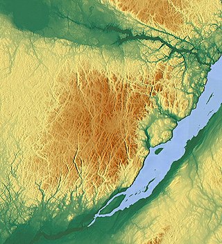
The Lac Jacques-Cartier massif is a massif and the highest mountain range of the Laurentian Mountains, in the Canadian province of Quebec. Located between the St. Lawrence River and the Saguenay Graben, the altitude of its plateau varies between 800 and 900 meters while its highest point, Mount Raoul Blanchard, reaches 1,181 metres (3,875 ft) of altitude.
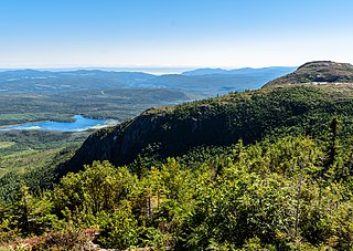
Mont du Lac des Cygnes is a mountain of the Jacques-Cartier Massif, located within the Grands-Jardins National Park in Quebec, Canada. Its summit culminating at 980 metres (3,220 ft) above sea level and overlooking the valley of the Rivière du Gouffre is one of the main attractions of the park.

