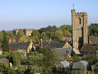
Montacute is a village and civil parish in Somerset, England, 4 miles (6.4 km) west of Yeovil. The village has a population of 831. The name Montacute is thought by some to derive from the Latin "Mons Acutus", referring to the conically acute St Michael's Hill dominating the village to the west. An alternative view is that it is named after Drogo de Montagu, whose family originated from Montaigu-les-Bois, in the arrondissement of Coutances. Mortain held Montacute after 1066, Drogo was a close associate.

Mudford is a village and parish in Somerset, England, situated 3 miles (4.8 km) from Yeovil in the South Somerset district on the River Yeo. The village has a population of 696. The parish includes the hamlets of Mudford Sock, West Mudford and Up Mudford.

The Grade I listed buildings in Somerset, England, demonstrate the history and diversity of its architecture. The ceremonial county of Somerset consists of a non-metropolitan county, administered by Somerset County Council, which is divided into five districts, and two unitary authorities. The districts of Somerset are West Somerset, South Somerset, Taunton Deane, Mendip and Sedgemoor. The two administratively independent unitary authorities, which were established on 1 April 1996 following the breakup of the county of Avon, are North Somerset and Bath and North East Somerset. These unitary authorities include areas that were once part of Somerset before the creation of Avon in 1974.
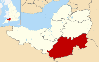
South Somerset is a local government district in the English county of Somerset. The South Somerset district occupies an area of 370 square miles (958 km2), stretching from its borders with Devon and Dorset to the edge of the Somerset Levels. The district has a population of about 158,000, and has Yeovil as its administrative centre.
The Church of St Michael, which stands next to the River Tone in Creech St Michael, Somerset, England dates from the 13th century and has been designated as a Grade I listed building.
Kerswell Priory was a small Cluniac priory in the parish of Broadhembury in Devon, England.
The Hundred of Tintinhull is one of the 40 historical Hundreds in the ceremonial county of Somerset, England, dating from before the Norman conquest during the Anglo-Saxon era although exact dates are unknown. Each hundred had a 'fyrd', which acted as the local defence force and a court which was responsible for the maintenance of the frankpledge system. They also formed a unit for the collection of taxes. The role of the hundred court was described in the Dooms (laws) of King Edgar. The name of the hundred was normally that of its meeting-place.
The Somerset Victoria County History is an encyclopaedic history of the county of Somerset in England, forming part of the overall Victoria County History of England founded in 1899 in honour of Queen Victoria. With ten volumes published in the series A History of the County of Somerset, the Somerset VCH is among the most substantial of the Victoria County Histories.

The Yeovil Scarplands are a natural region in southern England in the counties of Somerset and Dorset.
Mudford Manor is a historic 17th century Jacobean manor house situated on the Dorset/Somerset border in Mudford, Yeovil. The estate is surrounded by wild meadows with far-reaching views over the River Yeo to the village of Trent in Dorset. The Mudford Manor house is a six bed freehold detached house situated and is one of two properties situated on the Mudford Manor Estate along with Mudford Manor Barn.
There are over 670 scheduled monuments in the ceremonial county of Somerset in South West England. The county consists of a non-metropolitan county, administered by Somerset County Council, which is divided into five districts, and two unitary authorities. The districts of Somerset are West Somerset, South Somerset, Taunton Deane, Mendip and Sedgemoor. The two administratively independent unitary authorities, which were established on 1 April 1996 following the breakup of the county of Avon, are North Somerset and Bath and North East Somerset. These unitary authorities include areas that were once part of Somerset before the creation of Avon in 1974.

The Anglican Church of St Catherine at Montacute within the English county of Somerset was first built in the 12th century. It is a Grade II* listed building.
