Geography
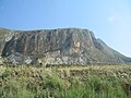
Monte Erice rises as an isolated limestone massif on the western edge of Sicily. Its base measures roughly 15 miles (24 km) in circumference, and its slopes descend steeply toward the coastal plain of Trapani and the Tyrrhenian Sea. [7]
The summit is occupied by Erice, enclosed within its ancient fortifications. To the west, the curtain wall with 16 remaining towers and three main gates—Porta Trapani, Porta del Carmine, and Porta Spada—once protected the city and sanctuary. [7]
Around the lower slopes lie a number of rural hamlets and frazioni including Casa Santa, Ballata, Lenzi, Napola, Pizzolungo, and Rigaletta. [8] Parts of the surrounding municipalities of Trapani, Valderice, and Paceco also extend onto the foothills of Monte Erice. [5]
Geology
The mountain consists largely of stratified limestone, compact and dense with occasional flint inclusions. At the base are horizontal beds of white carbonate rock streaked with manganese oxide, while higher layers include tuff and bluish marls containing marine fossils. [7]
Numerous caves have formed in the calcareous mass. Some, such as the Grotta dell’Armonia, contain stalactites; others, including the Grotta del Gigante at Portaspra and the Grotta dei Ciclopi at Martogna, were historically associated with legends of giants but have yielded palaeontological and prehistoric remains. [7] Additional sites such as the Grotta di Polifemo near Pizzolungo and the Grotta Emiliana preserve archaeological traces of habitation and fossil deposits. [7]
Monte Erice is supplied by perennial and seasonal springs, which historically fed troughs and basins used by residents and herders. These arise from rainfall and snowmelt filtering through the limestone strata before re-emerging at impermeable layers. [7]
Climate
Monte Erice has a cooler, more humid microclimate than the surrounding lowlands. Fog and low clouds are frequent, especially in winter. Northeasterly and northwesterly winds bring fog, rain and occasional snow; summers are drier with south-easterly breezes, while autumn often brings storms. [7]
Average daily highs range from about 14 °C (57 °F) in February to 28 °C (82 F) in August, with lows from 11–13 °C (52–55 °F) in winter to 25 °C (77 °F) in summer. [9]
Flora
The mountain supports varied Mediterranean flora, including evergreen shrubs, aromatic herbs, and seasonal wildflowers adapted to its humid conditions. [7]
Evergreen species include ivy (Hedera helix), mastic (Pistacia lentiscus), alaternus (Rhamnus alaternus), wild laurel, sage, marjoram, thyme, and artemisia. [7] Early-blooming plants include dungwort (Helleborus foetidus), snapdragon (Antirrhinum), and various mosses and lichens. Spring brings violets (Viola odorata), narcissus, hyacinths, anemones, daisies (Bellis perennis), poppies (Papaver rhoeas), broom (Genista), and wild chrysanthemums. In autumn and early winter, crocus (Colchicum autumnale) and cyclamens (Cyclamen repandum) flower. Modern surveys also record maquis and woodland with holm oak (Quercus ilex), downy oak (Quercus pubescens), carob (Ceratonia siliqua), olive, and wild pear (Pyrus pyraster), alongside cultivated vineyards and orchards on the foothills. [10]
Fauna
Historical accounts describe Monte Erice as home to a wide variety of birds, including pigeons, thrushes, quail, turtle doves, nightingales, kestrels, falcons, owls, and seasonal visitors such as cranes, herons, and plovers. By the 19th century, however, species once common in the area—such as francolins, fallow deer, and wild boar—had already become rare or extinct, a decline attributed to deforestation, agricultural expansion, and heavy hunting. [7]
Domestic herds of goats, sheep, and cattle continued to characterise the 19th century landscape, reflecting Sicily’s pastoral traditions. The mountain is also home to numerous butterflies, including the swallowtail (Papilio machaon), scarce swallowtail (Iphiclides podalirius), and two-tailed pasha (Charaxes jasius), as well as local snail species such as Helix scabriuscula, later named Ericina after the mountain. [7]
The coastal waters at the foot of Monte Erice historically supported tuna fisheries (tonnare) and coral harvesting, particularly at San Giuliano and Bonagia. [7]
Agriculture
The traditional economy of the Agro Ericino—the rural territory surrounding Monte Erice—was based on cereal cultivation, tree crops, and livestock. After wheat, the most important product was sumac (Rhus coriaria), cultivated for its leaves, bark, and twigs, which were processed for use in tanning and dyeing. [7] Nineteenth-century sources described Erice and neighbouring districts such as Alcamo and Trapani as major centres of sumac production, supplying both domestic and international markets.
Viticulture has a long history on the mountain. Vineyards at Bonagia were already noted for their wines in the early modern period, and by the nineteenth century new plantings at Lenzi, Rumena, and Ballata sustained Erice’s reputation for wine production. [7] Today, vineyards on the slopes fall under the DOC designation Erice DOC, established in 2004, which permits both native varieties such as Nero d'Avola and Grillo, and international ones including Syrah and Chardonnay. [11]
Olive groves were historically concentrated around Bonagia, Ragosia, and Ballata, and remain important today. The area produces high-quality extra virgin olive oil, primarily from the Nocellara del Belice and Cerasuola cultivars, which are well-adapted to the region’s arid summer conditions. [12] Citrus orchards, almonds, carob, figs, and prickly pears are also cultivated in favourable valleys and lower slopes, while ash trees (Fraxinus ornus) were once tapped for manna.
Livestock grazing was widespread into the eighteenth century, with Erice’s dairy products—including butter—praised in both classical and Renaissance sources. [7] A municipal slaughterhouse, built outside Erice's Porta del Carmine in 1748 and rebuilt in 1900, once served local meat production but later fell into disuse. [5] The area is still known for artisan sheep’s cheeses, notably Ericino, a hard-sheep cheese named after the mountain and recognised today in the national P.A.T. registry for Sicily. [13]
Tourism
Monte Erice is a destination for hiking, outdoor sports, and cultural tourism. The Club Alpino Italiano (CAI) maintains four marked trails connecting the summit with forests, chapels, and panoramic overlooks: [14]
- Sentiero di Sant’Anna (CAI 601) – A 5.5 km descent from Porta Trapani to the Sant’Anna Sanctuary, ending near the lower Trapani–Erice Cable Car station. [15]
- Sentiero Porta Castellammare – Tre Chiese (CAI 602) – A 4.5 km scenic loop past wild orchids, coastal viewpoints, and rural chapels. [16]
- Sentiero Torretta Pepoli (CAI 603) – A 2.7 km woodland path through the Bosco dei Runzi, with views of the Castle of Venus and Balio Towers. [17]
- Sentiero Demanio Forestale San Matteo (CAI 604) – A 6.9 km moderate trail to the Sicilian Forestry Corps Museum, passing pine forests and medieval sites. [18]
Monte Erice is also accessible via the Trapani–Erice Cable Car, which connects Trapani with the summit and provides transport to the mountain for visitors wishing to hike downhill via the marked CAI trails.
The slopes and surrounding foothills of Monte Erice also lie within the historic Val di Mazara wine region, an area traditionally associated with viticulture in western Sicily. Vineyards on the lower elevations reflect the cooler conditions and maritime influences typical of this part of the island.
Since 1954, the Cronoscalata Monte Erice hill climb motor race has taken place annually on its slopes. [19]
On the lower slopes, the Martogna pine forest hosts Parco Avventura Erice, an adventure park with rope courses, suspension bridges, and climbing elements. [20] [21]