
Ticino, sometimes Tessin, officially the Republic and Canton of Ticino or less formally the Canton of Ticino, is one of the 26 cantons forming the Swiss Confederation. It is composed of eight districts and its capital city is Bellinzona. It is also traditionally divided into the Sopraceneri and the Sottoceneri, respectively north and south of Monte Ceneri. Red and blue are the colours of its flag.

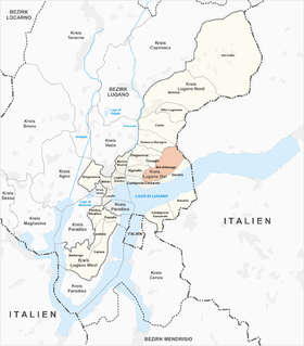
Lugano is a city and municipality in Switzerland, part of the Lugano District in the canton of Ticino. It is the largest city of both Ticino and the Italian-speaking southern Switzerland. Lugano has a population of 62,315, and an urban agglomeration of over 150,000. It is the ninth largest Swiss city.
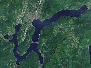
Lake Lugano is a glacial lake which is situated on the border between southern Switzerland and northern Italy. The lake, named after the city of Lugano, is situated between Lake Como and Lago Maggiore. It was cited for the first time by Gregory of Tours in 590 with the name Ceresio, a name which is said to have derived from the Latin word cerasus, meaning cherry, and refers to the abundance of cherry trees which at one time adorned the shores of the lake. The lake appears in documents in 804 under the name Laco Luanasco.

There are 108 municipalities in the canton of Ticino, Switzerland,. Municipalities (comuni) are grouped in circles (circoli) which are part of districts (distretti).

Lake Maggiore or Verbano is a large lake located on the south side of the Alps. It is the second largest lake in Italy and the largest in southern Switzerland. The lake and its shoreline are divided between the Italian regions of Piedmont and Lombardy and the Swiss canton of Ticino. Located halfway between Lake Orta and Lake Lugano, Lake Maggiore extends for about 65 kilometres between Locarno and Arona.

Porto Ceresio is a comune (municipality) on Lake Lugano in the Province of Varese in the Italian region Lombardy, located about 50 kilometres northwest of Milan and about 11 km (7 mi) northeast of Varese, on the border with Switzerland. As of 31 December 2020, it had a population of 2838 and an area of 5.1 square kilometres (2.0 sq mi).

Capolago is a village situated at the south-eastern extremity of Lake Lugano, in the Swiss canton of Ticino. Originally a municipality in its own right, Capolago is now a quarter of the municipality of Mendrisio, itself part of the district of Mendrisio.

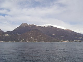
Monte Generoso is a mountain of the Lugano Prealps, located on the border between Switzerland and Italy and between Lake Lugano and Lake Como. The western and southern flanks of the mountain lie in the Swiss canton of Ticino, whilst the north-eastern flanks are in the Italian region of Lombardy.

The Giona is a ‘torrent’, or intermittent stream, which rises on the slopes of Monte Tamaro, in the Swiss canton of Ticino. After about 2 kilometres (1.2 mi), it enters the Italian province of Varese, forming the Val Veddasca before entering Lake Maggiore at Maccagno. Its course passes through the communes of Indemini in Switzerland and Veddasca, Curiglia con Monteviasco, Dumenza and Maccagno in Italy.

The Vedeggio is a river of the Swiss Canton Ticino which rises on the slopes of Monte Camoghè (2200m) between Bellinzona and Lugano, crosses the plain of Vedeggio, and enters Lake Lugano at Agno. Its final section, from the outskirts of Agno until its emission into Lake Lugano has been cut into a straight channel for ease of civil planning in the town.
Brè-Aldesago is a quarter of the city of Lugano, in the Swiss canton of Ticino.

Monte Tamaro is a mountain of the Lugano Prealps, overlooking Lake Maggiore in the Swiss canton of Ticino. Reaching a height of 1,962 metres above sea level, it is the highest summit of the chain located between Lake Maggiore and Lake Lugano, which also includes Monte Lema. It is also the most prominent summit of the canton.

The Monte San Salvatore is a mountain in the Lepontine Alps above Lake Lugano and the city of Lugano in Switzerland. The Monte San Salvatore funicular links the city with the summit of the mountain. The village on top of its peaks, Carona, is a popular destination to enjoy views over Lake Lugano and to walk through the exotic plants and flowers of Parco San Grato.
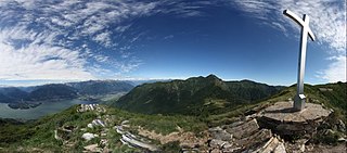
Monte di Tremezzo is a mountain of the Lugano Prealps in Lombardy, Italy. It is the highest summit of a ridge just south of Porlezza commune, lying between Lake Lugano and Lake Como. Due to its modest height it is a relatively easy mountain to climb, but due to its great prominence it provides a good view across the lakes, and over to the High Alps; mountains as far away as Finsteraarhorn, Dom and Monte Leone can be seen on a clear day.

The Monte San Salvatore funicular, or Funicolare Monte San Salvatore, is a funicular railway in the city of Lugano in the Swiss canton of Ticino. The line links a lower station in the Lugano suburb of Paradiso with an upper station at the summit of the Monte San Salvatore. The top yields a 360° panorama with views of the city, Lake Lugano, Monte Generoso and the Italian enclave of Campione.

Castagnola-Cassarate is a quarter of the city of Lugano, in the Swiss canton of Ticino.

The Cassarate is a river of the Swiss canton of Ticino. It rises in the upper part of the Val Colla, on the slopes of Monte Gazzirola and the San Lucio Pass. It flows into Lake Lugano at Lugano.
Monte Gambarogno is a mountain of the Lugano Prealps, overlooking Lake Maggiore in the canton of Ticino. It lies on the range between Lake Maggiore and Lake Lugano, culminating at Monte Tamaro.
The Poncione d'Arzo is a mountain of the Lugano Prealps, located on the border between Switzerland and Italy, about 250 meters east of Monte Pravello. It lies south of Lake Lugano, on the group culminating at Monte San Giorgio.

The Cinque Vette Park is a natural park, established by the Region of Lombardy on 19 June 2017. The park is located in the north-eastern part of the Province of Varese, in the Italian region of Lombardy. It takes the name from the main geographic features located in the park, the five mountain peaks. The project was launched with the aim of the three local councils of to preserve a green area and make it available for touristic-sportive-cultural initiatives above 500 meters of altitude. The primary goal of the park is to encourage the discovery of the natural features of the north-eastern part of Varese, which offers panoramic view points and preserves historical aspects such as: the remains of the Cadorna Line; the ruins of the Castle of Cuasso al Monte; the Artistic village of Boarezzo; the Saint Gemolo Abbey; the Alpine Village of Mount Piambello; and, the Hospital of Cuasso Al Monte.

