
Ticino, sometimes Tessin, officially the Republic and Canton of Ticino or less formally the Canton of Ticino, is one of the 26 cantons forming the Swiss Confederation. It is composed of eight districts and its capital city is Bellinzona. It is also traditionally divided into the Sopraceneri and the Sottoceneri, respectively north and south of Monte Ceneri. Red and blue are the colours of its flag.

Lake Maggiore or Verbano is a large lake located on the south side of the Alps. It is the second largest lake in Italy and the largest in southern Switzerland. The lake and its shoreline are divided between the Italian regions of Piedmont and Lombardy and the Swiss canton of Ticino. Located halfway between Lake Orta and Lake Lugano, Lake Maggiore extends for about 64 kilometres between Locarno and Arona.

Monte Generoso is a mountain of the Lugano Prealps, located on the border between Switzerland and Italy and between Lake Lugano and Lake Como. The western and southern flanks of the mountain lie in the Swiss canton of Ticino, whilst the north-eastern flanks are in the Italian region of Lombardy.

The Alpine foothills, or Prealps, may refer generally to any foothills at the base of the Alps in Europe. They are the transition zone between the High Alps and the Swiss Plateau and the Bavarian Alpine Foreland in the north, as well as to the Pannonian Basin (Alpokalja) in the east, the Padan Plain in the south and the Rhone Valley in the west.

Monte Ceneri is a mountain pass in the canton of Ticino in Switzerland. It connects the Magadino Plain and the Vedeggio Valley across the Lugano Prealps at an elevation of 554 metres (1,818 ft) above sea level. It provides the most direct route between the cities of Bellinzona and Lugano. Despite its name, Monte Ceneri is the lowest point on the crest between Monte Tamaro and the Camoghè.

The Gazzirola is a mountain of the Lugano Prealps on the Swiss-Italian border. Its summit is the highest point of the municipality of Lugano.

The Camoghè is a mountain of the Lugano Prealps, located east of Camorino in the canton of Ticino. It is the highest mountain that can be seen from Lugano city center.

Monte Lema is a mountain of the Lugano Prealps, located on the border between Switzerland and Italy. Its summit can easily reached by cable car from the village of Miglieglia (Ticino).

Monte Nudo is a mountain of Lombardy, Italy. It has an elevation of 1,237 metres. Administratively it belongs to the province of Varese.

Pizzo di Gino is a mountain of Lombardy, Italy. With an elevation of 2,245 m it is the highest peak of the Lugano Prealps.

Monte Rogoria is a mountain of the Lugano Prealps, located on the border between Switzerland and Italy, north of Astano, at the foot of the Monte Lema. The summit and the majority of the mountain are in the Swiss canton of Ticino, whilst a part of the north-western flank lies in the Italian region of Lombardy. It has an elevation of 1,184 metres above sea level. The view from the summit of the mountain encompasses the Lake Maggiore, the Borromean Islands and the Monte Rosa massif. There is no official hiking trail leading to the summit itself, but there are trails to the mountain pass Forcola respectively Passo di Monte Faëta at an altitude of 1,117 metres located close to the summit plateau. Starting points are: Astano, Miglieglia and Dumenza.

Monte San Primo is a mountain of Lombardy, Italy. It is 1,682 metres (5,518 ft) high and belongs to the province of Como.

SOIUSA is a proposal for a new classification system of the Alps from the geographic and toponomastic point of view. It was designed by Sergio Marazzi, Italian researcher and author of the Orographic Atlas of the Alps SOIUSA. His book was presented with the patronage of the Italian Alpine Club on 23 Jan 2006, but has yet to receive any formal acceptance.

The Brescia and Garda Prealps are a mountain range in the southern part of the Alps. They are located mainly in Lombardy but also in Trentino Alto Adige and in Veneto, in the northern part of Italy.
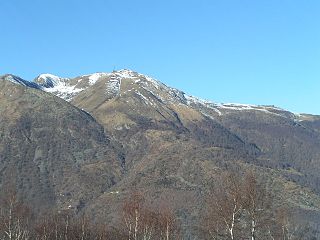
The Lugano Prealps are a mountain range in the western part of the Alps. They are located in Canton Ticino and Lombardy.
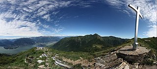
Monte Gambarogno is a mountain of the Lugano Prealps, overlooking Lake Maggiore in the canton of Ticino. It lies on the range between Lake Maggiore and Lake Lugano, culminating at Monte Tamaro.

Monte Gradiccioli is a mountain of the Lugano Prealps, located between Indemini and Sigirino in the canton of Ticino. It lies south of Monte Tamaro, on the range between Lake Maggiore and Lake Lugano.

Lombardy is an administrative region of Italy that is split into four geographic regions — mountains, alpine forest, and the upper and lower plains south of the Po river. These are crossed and dotted by dozens of rivers and lakes, the latter of which include some of the largest in Italy. The territory is the fourth largest in Italy by surface area with 24,000 square kilometres (9,300 sq mi).
Tamaro is a surname. Notable people with the surname include:
The Varese Prealps are a subsection of the Lugano Prealps, located between the Italian Province of Varese and Canton Ticino in Switzerland, between Lake Maggiore, Lake Lugano, the Val d’Agno and the Po Plain.


