
The Gazzirola is a mountain of the Lugano Prealps on the Swiss-Italian border. Its summit is the highest point of the municipality of Lugano.

The Camoghè is a mountain of the Lugano Prealps, located east of Camorino in the canton of Ticino. It is the highest mountain that can be seen from Lugano city center.

Monte Tamaro is a mountain of the Lugano Prealps, overlooking Lake Maggiore in the Swiss canton of Ticino. Reaching a height of 1,962 metres above sea level, it is the highest summit of the chain located between Lake Maggiore and Lake Lugano, which also includes Monte Lema. It is also the most prominent summit of the canton.

The Corni di Canzo, are a group of mountains located in the Triangolo lariano, to the south of Lake Como. Administratively they belong to the province of Como.
The Concarena is a mountain in Lombardy, northern Italy. It is multi summited and its highest peak is the Cima della Bacchetta, with a height of 2,549 m.

Monte Carmo di Loano is a mountain in Liguria, northern Italy, part of the Ligurian Prealps. It is located in the province of Savona. It lies at an altitude of 1389 metres.

Monte Galero is a mountain in Liguria, northern Italy, part of the Alps. It is located in the provinces of Savona and Cuneo. It lies at an altitude of 1708 metres and, after Monte Armetta, is the second highest summit of the Ligurian Prealps.

Monte Settepani is 1,386 metres high mountain in Liguria, northern Italy, part of the Ligurian Prealps.
Monte Bregagno is a mountain of Lombardy, Italy, It has an elevation of 2,107 metres.

Monte Caplone is a mountain between Lombardy and Trentino-Alto Adige/Südtirol, Italy. It has an elevation of 1,976 metres.

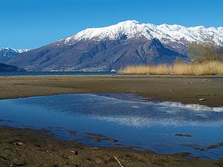
Monte Grona is a mountain of Lombardy, Italy. It has an elevation of 1,736 metres and belongs to the province of Como.

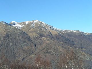
Monte Nudo is a mountain of Lombardy, Italy. It has an elevation of 1,237 metres. Administratively it belongs to the province of Varese.

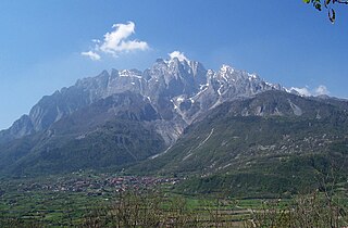
Pizzo di Gino is a mountain of Lombardy, Italy. With an elevation of 2,245 m it is the highest peak of the Lugano Prealps.

Monte San Primo is a mountain of Lombardy, Italy. It is 1,682 metres (5,518 ft) high and belongs to the province of Como.

SOIUSA is a proposal for a new classification system of the Alps from the geographic and toponomastic point of view. It was designed by Sergio Marazzi, Italian researcher and author of the Orographic Atlas of the Alps SOIUSA. His book was presented with the patronage of the Italian Alpine Club on 23 Jan 2006, but has yet to receive any formal acceptance.
The Lugano Prealps are a mountain range in the western part of the Alps. They are located in Canton Ticino and Lombardy.

Monte Cadria is a mountain in the Alps located in Italy. It is the highest peak of the Brescia and Garda Prealps.
The Vetta del Vallone is a mountain of the Lugano Prealps on the Swiss-Italian border. It is located between the Valle Morobbia (Ticino) and the Val Cavargna (Lombardy).
The Varese Prealps are a subsection of the Lugano Prealps, located between the Italian Province of Varese and Canton Ticino in Switzerland, between Lake Maggiore, Lake Lugano, the Val d’Agno and the Po Plain.
The Ligurian Prealps are a mountain range in northwestern Italy. They belong to the Ligurian Alps and are located between the regions of Piemonte and Liguria. Their highest summit is the monte Armetta, at an elevation of 1,739 metres (5,705 ft).
This page is based on this
Wikipedia article Text is available under the
CC BY-SA 4.0 license; additional terms may apply.
Images, videos and audio are available under their respective licenses.

