Somerset County is a county in the Commonwealth of Pennsylvania. As of the 2020 census, the population was 74,129. Its county seat is Somerset. The county was created from part of Bedford County on April 17, 1795, and named after the county of Somerset in England.

Pineville is a home rule-class city in Bell County, Kentucky, United States. It is the seat of its county. The population was 1,732 as of the 2010 census. It is located on a small strip of land between the Cumberland River and Pine Mountain.

Mount Athos is a mountain in the distal part of the eponymous Athos peninsula and site of an important centre of Eastern Orthodox monasticism in northeastern Greece. The mountain along with the respective part of the peninsula have been governed as the monastic community of Mount Athos, an autonomous region within the Hellenic Republic, ecclesiastically under the direct jurisdiction of the Ecumenical Patriarch of Constantinople, while the remainder of the peninsula forms part of the Aristotelis municipality. Mount Athos has been inhabited since ancient times and is known for its long Christian presence and historical monastic traditions, which date back to at least 800 AD during the Byzantine era. Because of its long history of religious importance, the well-preserved agrarian architecture within the monasteries, and the preservation of the flora and fauna around the mountain, Mount Athos was inscribed on the UNESCO World Heritage List in 1988.
Laurel Canyon is a mountainous neighborhood in the Hollywood Hills region of the Santa Monica Mountains, within the Hollywood Hills West district of Los Angeles, California. The main thoroughfare of Laurel Canyon Boulevard connects the neighborhood with the more urbanized parts of Los Angeles to the north and south, between Ventura Boulevard and Hollywood Boulevard.
Anavatapta is the lake lying at the center of the world, according to ancient Indian tradition. The name Anavatapta means "heat-free"; the waters of the lake were thought to be able to soothe the fires that torment beings. Anavatapta is also the name of the dragon that was said to live in the lake; having become a bodhisattva, it was free from the distresses that plague other dragons, which are tormented by fiery heat and preyed on by garudas.

The Laurel Falls Trail is an American hiking trail, in the Great Smoky Mountains National Park of Sevier County, Tennessee. The trail ascends Cove Mountain, leading past Laurel Falls, one of the most popular waterfalls in the national park, en route to the summit of Cove Mountain and the Cove Mountain fire tower.

The Necropolis of Pantalica is a collection of cemeteries with rock-cut chamber tombs in southeast Sicily, Italy. Dating from the 13th to the 7th centuries BC, there was thought to be over 5,000 tombs, although the most recent estimate suggests a figure of just under 4,000. They extend around the flanks of a large promontory located at the junction of the Anapo river with its tributary, the Calcinara, about 23 km (14 mi) northwest of Syracuse. Together with the city of Syracuse, Pantalica was listed as a UNESCO World Heritage Site in 2005.

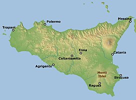
The Anapo is a river in Sicily whose ancient Greek name is similar to the word for "swallowed up" and at many points on its course it runs underground. The Greek myth of Anapos is associated with it.
Ararat is an unincorporated community in Patrick County, Virginia, United States, south of the Blue Ridge Parkway and north of Mount Airy, North Carolina. Ararat is located near the Virginia–North Carolina state line about five miles (8.0 km) north of Mount Airy and about 25 miles (40 km) west of Stuart, Virginia. The community's name comes from the Ararat River which flows through the area. The River takes its name from the Jefferson Fry Map of 1751, which calls Pilot Mountain part of the "Mountains of Ararat." The Saura Indian name for nearby Pilot Mountain in Surry County, North Carolina is "The Pilot" and the mountain reverted to that. The large monadnock mountain was thought to resemble a bullfrog and the Native Americans named it "Ratratrat," after the sound the animal makes. Early white settlers thought what they were saying sounded like "Ararat," the mountain which, according to the Bible, was the landing point of Noah's Ark.

Mount Kephart is a mountain in the central Great Smoky Mountains, located in the Southeastern United States. The Appalachian Trail crosses the mountain's south slope, making it a destination for thru-hikers. The Jumpoff, a 1,000-foot (300 m) cliff on the northeast side of the mountain, has views of the central and eastern Smokies. A stand of Southern Appalachian spruce-fir forest coats the mountain's upper elevations.

The Nebrodi is a mountain range that runs along the north east of Sicily. Together with the Madonie and the Peloritani, they form the Sicilian Apennines.
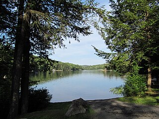
Erving State Forest is a publicly owned forest with recreational features located north of the Millers River in the towns of Erving, Warwick, and Orange, Massachusetts. The property is centered on Laurel Lake, a 51-acre (21 ha) body of water that has been a popular recreational destination since the 1930s. The forest's network of roads and hiking trails were largely created by the Civilian Conservation Corps. The forest is managed by the Department of Conservation and Recreation.

The Hyblaean Mountains is a mountain range in south-eastern Sicily, Italy. It straddles the provinces of Ragusa, Syracuse and Catania. The highest peak of the range is Monte Lauro, at 986 m.
The Pittsburgh, Westmoreland, & Somerset Railroad (PW&S) was a short-lived railroad that connected the Pennsylvania communities of Ligonier and Somerset, running over a mountain known as Laurel Hill or Laurel Mountain.

Laurel is an unincorporated community in Washington County, Oregon, United States. Settled in 1872, the community is located between Hillsboro and Newberg, in the southern portion of the Tualatin Valley in the foothills of the Chehalem Mountains. The community retains its agricultural heritage. Laurel is served by the Hillsboro School District and includes the century-old Laurel Valley Store building, which is in the process of being turned into a restaurant. As an unincorporated community, Laurel has no defined boundaries or population statistics of its own.

Monte Casale is a mountainous elevation on Sicily in Italy, reaching 910m above sea level, which formed part of the oldest volcanic formation of the Hyblaean Mountains. Their peaks form the boundary between the present-day provinces of Syracuse and Ragusa and the watershed between the Irminio and Anapo rivers. It is notable for its important archaeological remains, discovered by Paolo Orsi early in the 20th century and identified by him with the ancient Greek city of Casmene.

The National Popular Alliance or ANAPO was a political party in Colombia. It was founded in 1961 as a movement by the ex-president Gustavo Rojas Pinilla and was disbanded in 1998. Many ANAPO leaders and militants joined the Independent Democratic Pole coalition.

The Laurel Fork is a 15.7-mile-long (25.3 km) stream in Virginia and West Virginia, United States. The stream flows north from Highland County, Virginia, where its source and the majority of its length is located, to its mouth in Pendleton County, West Virginia. Laurel Fork is a tributary to the North Fork South Branch Potomac River, making it a part of the Potomac River watershed. The area surrounding Laurel Fork is home to several plant and animal species found nowhere else in Virginia, and is a prime example of a northern boreal forest in the state.

The mining industry of Sudan is mostly driven by extraction fuel minerals, with petroleum accounting for a substantial contribution to the country's economy, until the autonomous region of Southern Sudan became an independent country in July 2011. Gold, iron ore, and base metals are mined in the Hassai Gold Mine and elsewhere. Chromite is another important mineral extracted from the Ingessana Hills. Other minerals extracted are gypsum, salt, and cement. Phosphate is found in Mount Kuoun and Mount Lauro in eastern Nuba. Reserves of zinc, lead, aluminium, cobalt, nickel in the form of block sulfides, and uranium are also established. Large reserves of iron ore have been established.
Woolly Tops Mountain is a mountain in the Great Smoky Mountains in Sevier County, Tennessee. It has an elevation of 5,482 feet (1,671 m), and is located in the eastern half of the Great Smoky Mountains National Park.