
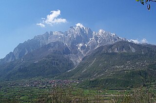
Monte Viso or Monviso is the highest mountain of the Cottian Alps. It is located in Italy close to the French border. Monte Viso is well known for its pyramid-like shape and, because it is higher than all its neighbouring peaks by about 500 m, it can be seen from a great distance, including from the Piedmontese plateau, the Langhe, the Theodulpass in the Zermatt ski area, the col du Galibier and the summits of the Mont Blanc massif. On a very clear day it can be seen from the spires of Milan Cathedral.

Rocca la Meja is a mountain in the Cottian Alps, in the comune of Canosio, Piedmont, northern Italy. It has an altitude of 2,831 m and it is located in the Maira Valley.
The Concarena is a mountain in Lombardy, northern Italy. It is multi summited and its highest peak is the Cima della Bacchetta, with a height of 2,549 m.

Monte Galero is a mountain in Liguria, northern Italy, part of the Alps. It is located in the provinces of Savona and Cuneo. It lies at an altitude of 1708 metres and, after Monte Armetta, is the second highest summit of the Ligurian Prealps.
Monte Granero is a peak in the Cottian Alps, in western Piedmont, northern Italy. It has an elevation of 3,170 m. It is located between the Val Pellice and the Valle Po, not far from the boundary with France.

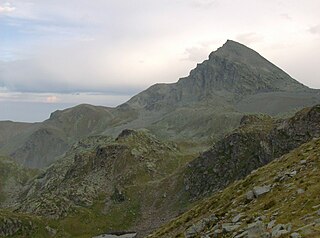
Monte Argentera is a mountain in the Maritime Alps, in the province of Cuneo, Piedmont, northern Italy. With an elevation of 3,297 metres (10,817 ft), it is the highest peak in the range.
SOIUSA code is the code used in the International Standardized Mountain Subdivision of the Alps, a proposal by Italian Alpinist, Sergio Marazzi, to re-categorize the mountains and mountain ranges of the Alps. The proposal has been aired since 2005 but has yet to receive official recognition.

Monte Orsiera is a mountain in the Cottian Alps belonging to the Province of Turin (Italy).

The Punta Ramiere or Bric Froid is a mountain in the Cottian Alps belonging to the department of Hautes-Alpes (FR) and the province of Turin (IT). It's the highest peak of the long stretch of the Po/Rhone water divide starting from the Aiguille de Scolette (north) and ending with the Monviso group (south).
Monte Armetta is a mountain in Piedmont, northern Italy, part of the Alps. At an altitude of 1,739 metres is the highest summit of the Ligurian Prealps.

Bric Ghinivert or Eiminàl is a mountain of the Cottian Alps located in Italy.

Monte Politri or Bric Rosso is a 3,026 m a.s.l. mountain of the Cottian Alps, located in Italy.
Monte Albergian is a 3,041 m a.s.l. mountain of the Cottian Alps, located in Italy. A battalion of 3rd Alpini Regiment, which during World War I earned a Silver Medal of Military Valor, was named after Monte Albergian.

Punta Tempesta is a 2,679 m a.s.l. mountain of the Cottian Alps, located in Italy.

The Punta Merciantaira or Grand Glaiza is a 3,293 metres high mountain of the Cottian Alps.
The Viso Mozzo is a 3,019 metres high mountain on the Italian side of the Cottian Alps.

The Mont-Fallère or Mont Fallère is a 3,061.5 metres high mountain belonging to the Italian side of Pennine Alps.

The Punta Cornour is a 2,868 metres high mountain on the Italian side of the Cottian Alps.

The Cima Ciantiplagna is a mountain in the Cottian Alps belonging to the Province of Turin (Italy).

The Monte Birrone is a 2,131-metre (6,991 ft) high mountain in the Cottian Alps, belonging to the Italian province of Cuneo.

