Montecatini Val di Cecina

Last updated
Montecatini Val di Cecina
Comune di Montecatini Val di Cecina
Montecatini banda.JPG
Montecatini Val di Cecina-Stemma.png
Location of Montecatini Val di Cecina
Montecatini Val di Cecina
Italy provincial location map 2016.svg
Red pog.svg
Montecatini Val di Cecina
Location of Montecatini Val di Cecina in Italy
Italy Tuscany location map.svg
Red pog.svg
Montecatini Val di Cecina
Montecatini Val di Cecina (Tuscany)
Coordinates: 43°23′37″N10°45′0″E / 43.39361°N 10.75000°E / 43.39361; 10.75000 Coordinates: 43°23′37″N10°45′0″E / 43.39361°N 10.75000°E / 43.39361; 10.75000
Country Italy
Region Tuscany
Province Pisa (PI)
Frazioni Buriano, Casaglia, Casino di Terra, Gello, La Sassa, Miemo, Ponteginori, Querceto
Government
  MayorSandro Cerri (since April 2008)
Area
[1]
  Total155.19 km2 (59.92 sq mi)
Elevation
416 m (1,365 ft)
Population
 (2014) [2]
  Total1,768
  Density11/km2 (30/sq mi)
Demonym(s) Montecatinesi
Time zone UTC+1 (CET)
  Summer (DST) UTC+2 (CEST)
Postal code
56040
Dialing code 0588
Patron saint St. Blaise
Saint dayFebruary 3
Website www.comune.montecatini.pi.it

Montecatini Val di Cecina is a small hilltown and comune in the province of Pisa in Tuscany (central Italy). Located approximatively 60 kilometres (37 miles) south of Pisa, the medieval town sits on the Poggio la Croce hill overlooking the Cecina Valley and the larger hilltown of Volterra, which lies just 15 km (9 miles) away.

Contents

Local agriculture and the old copper mine provided Montecatini Val di Cecina with a degree of prosperity in the early Middle Ages. Like many Tuscan hilltop towns, its medieval aspect has been preserved precisely because lack of economic development. Today, Montecatini Val di Cecina is enjoying a small economic revival through tourism though on a modest scale.

Economy

The mines

Since the Etruscan, the history of Montecatini Val di cecina is closely related with its copper mine which remained operational until 1907 and it is now converted to a museum. The town has given name to one of the biggest mining industries in Europe in the early 20th century, the Montecatini - General Society for the Mining and Chemical Industry (Italian Montecatini - Società Generale per l'Industria Mineraria e Chimica), which later merged in the more famous Montedison. Other subsoil resources in the area were salt, alabaster, chalcedony, lignite and geothermal energy.

History

Montecatini Val di Cecina was first settled by ancient Etruscans, who populated the nearby city of Volterra. Later it served as a Roman look-out post as it overlooks what was a busy Roman road. The castle and tower that dominate the town were built in the Middle Ages by Filippo Belforti, whose family ruled the territory for about a century. By the 11th century, Montecatini Val di Cecina was in the Catholic parish administered from nearby Gabretto. In 1351, the area came under the rule of the Bishop of Volterra. In 1452, it was absorbed into the Republic of Florence (later Grand Duchy of Tuscany), to which it belonged until the unification of Italy in 1861. [3]

Main sights

Inside the village walls, which feature cylindrical towers around the perimeter, medieval buildings are tightly spaced, separated by narrow streets or alleys, and a few small piazzas. The town is dominated by the Belforti tower.

Other buildings include the Palazzo Pretorio, with an elegant porch that runs underneath a cross-ribbed vaulted roof supported by six Ionian columns, and San Biagio built in the romanesque - gothic style during the 14th Century. The church has an asymmetrical shape with a very plain portal facing a side street. The church is divided by a central nave with two side aisles separated by columns.

Nearby there is the frazione (village) of Querceto, with the Romanesque parish church Chiesa San Giovanni.

A fortified tower is on a hill offering a view of the country stretching toward Volterra and the Tyrrhenian Sea, is the village of La Sassa. An old copper mine lies between two other old villages, Casaglia and Gello.

Related Research Articles

Montalcino Comune in Tuscany, Italy

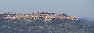
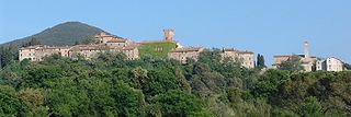
Montalcino is a hill town and comune in the province of Siena, Tuscany, central Italy.

Volterra Comune in Tuscany, Italy

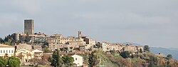
Volterra is a walled mountaintop town in the Tuscany region of Italy. Its history dates from before the 8th century BC and it has substantial structures from the Etruscan, Roman, and Medieval periods.

Province of Pisa Province of Italy

The province of Pisa is a province in the Tuscany region of central Italy. Its capital is the city of Pisa. With an area of 2,448 square kilometres (945 sq mi) and a total population of 421,642, it is the second most populous and fifth largest province of Tuscany. It is subdivided into 37 comuni.

Populonia Frazione in Tuscany, Italy

Populonia or Populonia Alta today is a frazione of the comune of Piombino. As of 2009 its population was 17. Populonia is especially noteworthy for its Etruscan remains, including one of the main necropolis in Italy, discovered by Isidoro Falchi.

San Miniato Comune in Tuscany, Italy

San Miniato is a town and comune in the province of Pisa, in the region of Tuscany, Italy.

Bibbona Comune in Tuscany, Italy

Bibbona is a comune (municipality) in the Province of Livorno in the Italian region Tuscany, located about 80 kilometres (50 mi) southwest of Florence and about 40 kilometres (25 mi) southeast of Livorno in the Val di Cecina.

Campiglia Marittima Comune in Tuscany, Italy

Campiglia Marittima is a comune (municipality) in the Province of Livorno in the Italian region Tuscany, located about 90 kilometres (56 mi) southwest of Florence and about 60 kilometres (37 mi) southeast of Livorno.

Lajatico Comune in Tuscany, Italy

Lajatico is a comune (municipality) in the Province of Pisa in the Italian region Tuscany, located about 50 kilometers (31 mi) southwest of Florence and about 40 kilometers (25 mi) southeast of Pisa. Lajatico sits in mainly hilly terrain at variable elevations from 100 to 650 meters above sea level) and dominates both the end of the Valdera valley and the opening of the valley known as Val di Cecina.

Pomarance Comune in Tuscany, Italy

Pomarance is a comune (municipality) in the Province of Pisa in the Italian region Tuscany, located about 60 kilometres (37 mi) southwest of Florence and about 60 km southeast of Pisa.

Tuscany Region of Italy

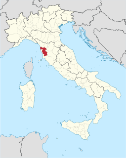
Tuscany is a region in central Italy with an area of about 23,000 square kilometres and a population of about 3.8 million inhabitants. The regional capital is Florence (Firenze).

Querceto, Montecatini Val di Cecina Frazione in Tuscany, Italy

Querceto is a frazione in the comune of Montecatini Val di Cecina of the Province of Pisa in Italy. The village is located on the slopes of Mount Aneo, near Volterra


The Pomarancina is a breed of domestic sheep from Tuscany in central Italy. It is raised mainly in the comune of Pomarance, from which it takes its name, and in the neighbouring comuni of Castelnuovo di Val di Cecina, Montecatini Val di Cecina and Volterra, all in the province of Pisa; some are kept in other parts of Tuscany, in the provinces of Grosseto, Livorno, Lucca and Siena. It is one of the forty-two autochthonous local sheep breeds of limited distribution for which a herdbook is kept by the Associazione Nazionale della Pastorizia, the Italian national association of sheep-breeders.

San Biagio, Montecatini Val di Cecina

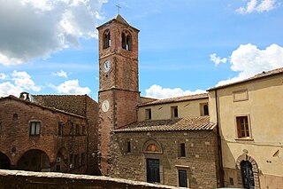
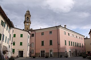
San Biagio is a romanesque-gothic style Roman Catholic church. It was erected during the 14th century in the town of Montecatini Val di Cecina, province of Pisa, in the region of Tuscany, Italy.

Casaglia, Montecatini Val di Cecina Frazione in Tuscany, Italy

Casaglia is a village in Tuscany, central Italy, administratively a frazione of the comune of Montecatini Val di Cecina, province of Pisa. At the time of the 2001 census its population was 10.

Miemo Frazione in Tuscany, Italy

Miemo is a village in Tuscany, central Italy, administratively a frazione of the comune of Montecatini Val di Cecina, province of Pisa. At the time of the 2001 census its population was 13.

Gello, Montecatini Val di Cecina Frazione in Tuscany, Italy

Gello is a village in Tuscany, central Italy, administratively a frazione of the comune of Montecatini Val di Cecina, province of Pisa. At the time of the 2006 parish census its population was 88.

Ponteginori Frazione in Tuscany, Italy

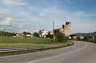
Ponteginori is a village in Tuscany, central Italy, administratively a frazione of the comune of Montecatini Val di Cecina, province of Pisa. At the time of the 2001 census its population was 532.

Casino di Terra Frazione in Tuscany, Italy

Casino di Terra is a village in Tuscany, central Italy, administratively a frazione of the comuni of Guardistallo and Montecatini Val di Cecina, province of Pisa. At the time of the 2001 census its population was 97.

La Sassa Frazione in Tuscany, Italy

La Sassa, or simply Sassa, is a village in Tuscany, central Italy, administratively a frazione of the comune of Montecatini Val di Cecina, province of Pisa. At the time of the 2001 census its population was 152.

Buriano is a village in Tuscany, central Italy, administratively a frazione of the comune of Montecatini Val di Cecina, province of Pisa.

References

  1. "Superficie di Comuni Province e Regioni italiane al 9 ottobre 2011". Italian National Institute of Statistics. Retrieved 16 March 2019.
  2. "Popolazione Residente al 1° Gennaio 2018". Italian National Institute of Statistics. Retrieved 16 March 2019.
  3. [ dead link ]