Related Research Articles

Hampshire County is a county in the U.S. state of West Virginia. As of the 2010 census, the population was 23,964. Its county seat is Romney, West Virginia's oldest town (1762). The county was created by the Virginia General Assembly in 1754, from parts of Frederick and Augusta Counties (Virginia) and is the state's oldest county. The county lies in both West Virginia's Eastern Panhandle and Potomac Highlands regions.

The South Branch Potomac River has its headwaters in northwestern Highland County, Virginia near Hightown along the eastern edge of the Allegheny Front. After a river distance of 139 miles (224 km), the mouth of the South Branch lies east of Green Spring in Hampshire County, West Virginia where it meets the North Branch Potomac River to form the Potomac.
The Northwestern Turnpike is a historic road in West Virginia, important for being historically one of the major roads crossing the Appalachians, financed by the Virginia Board of Public Works in the 1830s. In modern times, west of Winchester, Virginia, U.S. Route 50 follows the path of the Northwestern Turnpike into West Virginia, whose major Corridor D project follows the western section of the original Northwestern Turnpike.

The Sloan–Parker House, also known as the Stone House, Parker Family Residence, or Richard Sloan House, is a late-18th-century stone residence near Junction, Hampshire County, in the U.S. state of West Virginia. It was built on land vacated by the Shawnee after the Native American nation had been violently forced to move west to Kansas following their defeat at the Battle of Point Pleasant in 1774. The building was added to the National Register of Historic Places on June 5, 1975, becoming Hampshire County's first property to be listed on the register. The Sloan–Parker House has been in the Parker family since 1854. The house and its adjacent farm are located along the Northwestern Turnpike in the rural Mill Creek valley.

Green Spring is a census-designated place (CDP) and railroad town in Hampshire County, West Virginia, United States. As of the 2010 census, its population was 218. Green Spring is located north of Springfield on Green Spring Road near the confluence of the North and South Branches of the Potomac River. Green Spring is also the location of the South Branch Valley Railroad's terminus with the old Baltimore & Ohio Railroad mainline. Green Spring is the site of a one-lane low-water toll bridge that connects Green Spring Road to Maryland Route 51 in Oldtown, Allegany County, Maryland. This bridge is one of only 17 privately owned toll bridges in the United States. The toll for the bridge is currently US$1.50.

Hanging Rocks are perpendicular cliffs rising nearly 300 feet (91 m) above the South Branch Potomac River in Hampshire County in the U.S. state of West Virginia. Hanging Rocks are located four miles (6 km) north of Romney at Wappocomo on West Virginia Route 28. Hanging Rocks has also been known throughout its history as Painted Rocks and Blue's Rocks. When distinguished from the "Lower Hanging Rocks" along the South Branch at Blues Beach to the north, Hanging Rocks is referred to as Upper Hanging Rocks.
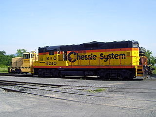
The South Branch Valley Railroad consists of a 52.4 mile (84.33 km) length of railroad in the U.S. state of West Virginia extending north along the South Branch Potomac River from Petersburg to the CSXT mainline at Green Spring adjacent to the Potomac River. At Green Spring, the CSXT mainline connects the SBVR to Cumberland, Maryland to the west and Martinsburg, West Virginia to the east. SBVR has been owned and operated by the West Virginia State Rail Authority (SRA) since it was sold by the Baltimore & Ohio Railroad on October 11, 1978. Upon purchasing the B&O's South Branch line, West Virginia became the first state in the United States to both own and operate a commercial freight railroad. In 1985, major flooding of the South Branch Valley destroyed most of the rail line, including all three bridges that crossed the South Branch Potomac River. Despite talk of shutting down the railroad after the flood, reconstruction began two years later.

Indian Mound Cemetery is a cemetery located along the Northwestern Turnpike on a promontory of the "Yellow Banks" overlooking the South Branch Potomac River and Mill Creek Mountain in Romney, West Virginia, United States. The cemetery is centered on a Hopewellian mound, known as the Romney Indian Mound. Indian Mound Cemetery is also the site of Fort Pearsall, the Confederate Memorial, Parsons Bell Tower, and reinterments from Romney's Old Presbyterian Cemetery. The cemetery is currently owned and maintained by the Indian Mound Cemetery Association, Inc.

McNeill's Rangers was an independent Confederate military force commissioned under the Partisan Ranger Act (1862) by the Confederate Congress during the American Civil War. The 210 man unit was formed from Company E of the 18th Virginia Cavalry and the First Virginia Partisan Rangers. After the repeal of the Act on February 17, 1864, McNeill's Rangers was one of two partisan forces allowed to continue operation, the other being 43rd Battalion Virginia Cavalry. Both of these guerrilla forces operated in the western counties of Virginia and West Virginia. The Rangers were known to exercise military discipline when conducting raids. However, many Union generals considered Captain John Hanson McNeill (1815–1864) and his men to be "bushwhackers," not entitled to protection when captured, as was the case with other prisoners of war.

Wappocomo is a late 18th-century Georgian mansion and farm overlooking the South Branch Potomac River north of Romney, Hampshire County, West Virginia, USA. It is located along Cumberland Road and the South Branch Valley Railroad.
The Capon and North Branch Turnpike was a 19th-century turnpike in Hampshire County in the U.S. state of Virginia. The turnpike facilitated increased communication and transportation between Cumberland, Maryland and Winchester, Virginia via the Northwestern Turnpike in Capon Bridge, West Virginia. As of July 2010, the Capon and North Branch Turnpike's original route is made up of segments of West Virginia Route 28, Springfield Pike, Slanesville Pike, and Cold Stream Road.

The Virginia Argus and Hampshire Advertiser, often referred to simply as the Virginia Argus, was a weekly newspaper published between July 1850 and August 1861 in Romney, Virginia. The paper's circulation of 800 copies was the second-highest in Hampshire County, after the South Branch Intelligencer's. The Virginia Argus ceased publication following its closure by the Union Army during the American Civil War, after which it was not revived.
James Sloan Kuykendall was an American farmer, lawyer, and Democratic politician in the U.S. state of West Virginia. Kuykendall was twice elected as a member of the West Virginia House of Delegates representing Hampshire County. Kuykendall also served three terms as the mayor of Romney and later fulfilled the position of city attorney.

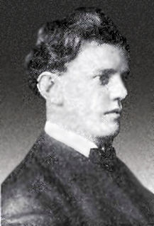
William Benjamin Cornwell was an American lawyer, businessperson, newspaper editor and publisher, and railroad and timber executive in the U.S. state of West Virginia. He was an older brother of writer and newspaper publisher Marshall S. Cornwell (1871–1898) and of West Virginia Governor John J. Cornwell (1867–1953).
Romney Classical Institute was a 19th-century coeducational collegiate preparatory school in Romney, Virginia, between 1846 and shortly after 1866. Romney had previously been served by Romney Academy, but by 1831 the school had outgrown its facilities. The Virginia General Assembly permitted the Romney Literary Society to raise funds for a new school through a lottery. On December 12, 1846, the assembly established the school and empowered the society with its operation.

Valley View is a mid-19th-century Greek Revival residence and farm overlooking the South Branch Potomac River northwest of Romney, West Virginia. The house is atop a promontory where Depot Valley joins the South Branch Potomac River valley.
Valley was a populated place and post office on the South Branch line of the Baltimore and Ohio Railroad in the U.S. state of West Virginia. It was centered near the intersection of West Sioux Lane and Depot Valley Road, now located within the present-day corporate boundaries of Romney. Valley developed in 1884 following the completion of the South Branch line when the rail line's original southern terminus and corresponding Romney Depot were built there. The United States Post Office Department established a post office at Valley on May 19, 1928, remaining in operation until its disestablishment on June 15, 1937. Following the closure of Valley's post office, its mail was routed through the post office in Romney.

The Capon Lake Whipple Truss Bridge, formerly known as South Branch Bridge or Romney Bridge, is a historic Whipple truss bridge in Capon Lake, West Virginia. It is located off Carpers Pike and crosses the Cacapon River. The bridge formerly carried Capon Springs Road over the river, connecting Capon Springs and Capon Lake.
William C. Clayton was an American educator, lawyer, politician, and businessperson in the U.S. state of West Virginia. Clayton served in the West Virginia Senate representing the Eleventh Senatorial District of West Virginia from 1875 until 1879. He was twice principal of the Romney Classical Institute in Romney in 1853 and 1866.
References
- 1 2 3 4 5 6 7 8 9 Brannon, Selden W., ed. (1976). Historic Hampshire: A Symposium of Hampshire County and Its People, Past and Present. Parsons, West Virginia: McClain Printing Company. ISBN 978-0-87012-236-1. OCLC 3121468.
- 1 2 3 4 Maxwell, Hu; Howard Llewellyn Swisher (1897). History of Hampshire County, West Virginia. Morgantown, West Virginia: A. B. Boughner.
- ↑ Virginia General Assembly (1850). Journal of the Senate of Virginia. Commonwealth of Virginia. Archived from the original on December 18, 2017.
- 1 2 3 4 Lee, Elizabeth Oliver (2008). ""Potomac's Valley shall become a domain we create:" Commercialism and the South Branch Valley, 1750-1800" (PDF).Cite journal requires
|journal=(help) - 1 2 3 4 5 6 Commonwealth of Virginia (1854). Governor's message and reports of the public officers of the state, of the boards of directors, and of the visitors, superintendents, and other agents of public institutions or interests of Virginia, Part 3. William F. Ritchie, public printer. Archived from the original on December 18, 2017.
- 1 2 3 Commonwealth of Virginia (1859). Annual reports of officers, boards and institutions of the Commonwealth of Virginia. Superintendent of Public Printing (etc.). Archived from the original on December 18, 2017.
- 1 2 Virginia Board of Public Works (1860). Annual report of the Board of Public Works to the General Assembly of Virginia, with the accompanying documents, Part 1. Superintendent of Public Printing (etc.). Archived from the original on December 18, 2017.
- ↑ Morrison, Charles (1971). Wappatomaka: A Survey of the History and Geography of the South Branch Valley. Parsons, West Virginia: McClain Printing Company. ISBN 0-87012-107-3.
- ↑ Wayland, John W. (1998). The Washingtons and Their Homes. Genealogical Publishing Com. ISBN 0-8063-4775-9. Archived from the original on February 7, 2011.
- ↑ West Virginia Departments of Archives and History (1963). West Virginia History, Volume 25. West Virginia Departments of Archives and History.
- ↑ Poland, Jr., Charles P. (2004). The Glories of War: Small Battle and Early Heroes of 1861. AuthorHouse. ISBN 978-1-4184-4067-1. Archived from the original on June 24, 2016.
- 1 2 Kerns, Wilmer L.; Roberta R. Munske (2004). Hampshire County, West Virginia 1754-2004. Romney, West Virginia: The Hampshire County 250th Anniversary Committee. ISBN 0-9715738-2-4. Archived from the original on January 1, 2014.
- ↑ Vernon, George W. F.; L. Allison Wilmer; James H. Jarrett (1898). History and Roster of Maryland Volunteers, War of 1861-5, Volume 1. Press of Guggenheimer, Weil & Co.
- ↑ Williams, Thomas John Chew; James Walter Thomas (1969). Volume 1 of History of Allegany County, Maryland. Regional Pub. Co. Archived from the original on December 18, 2017.
- 1 2 3 Strother, David Hunter (1866). Harper's Magazine, Volume 33. Harper's Magazine Co. Archived from the original on December 18, 2017.
- 1 2 3 United States Department of War (1866). Annual Report of the Secretary of War, Volume 1, Part 10. U.S. Government Printing Office. Archived from the original on December 18, 2017.
- ↑ West Virginia (1868). Acts of the Legislature of West Virginia, Volume 1. J. Frew, Public Printer. Archived from the original on December 18, 2017.
