Moot Hall, Steeple Bumpstead

Last updated

Moot Hall, Steeple Bumpstead
Moot Hall, Steeple Bumpstead (geograph 5524415).jpg
Moot Hall, Steeple Bumpstead
LocationChurch Street, Steeple Bumpstead
Coordinates 52°02′33″N0°26′54″E / 52.0424°N 0.4484°E / 52.0424; 0.4484 Coordinates: 52°02′33″N0°26′54″E / 52.0424°N 0.4484°E / 52.0424; 0.4484
Built1592
Architectural style(s) Tudor style
Listed Building – Grade II*
Official nameThe Moot Hall
Designated7 August 1952
Reference no.1146551
Essex UK location map.svg
Red pog.svg
Shown in Essex

The Moot Hall, also known as the Old School House, is a former market hall and school on Church Street in Steeple Bumpstead, Essex, England. The building, which now operates as a library and parish meeting room, is a Grade II* listed building. [1]

Contents

History

The building was commissioned as a market hall by the wealthy villagers of Steeple Bumpstead in the late 16th century. [2] It was designed in the Tudor style using timber frame construction, and was completed in 1592. [1] [3] The design involved a broadly symmetrical main frontage of three bays facing northeast down Chapel Street. The first floor involved extensive use of jettied timber framing allowing the creation of extra space for the meeting room on that floor. The ground floor was originally open but it was enclosed in the 18th century. [4] On the first floor, there was a prominent tri-partite casement window. On the northwest side, there was an external staircase which was also encased in the 18th century. [1] At roof level there is a hip roof surmounted, at the apex, by a statue of a lion holding a shield with the Royal coat of Arms of the Tudor monarchs. [5]

In the 19th century, the building was at the centre of a dispute between the lord of the manor, George Gent, whose seat was at Moyns Park, and the villagers as to whether it was the right of the lord of the manor or the right of the villagers to appoint the headmaster of the local school which was based in the building. The matter was eventually passed to an ecclesiastical court which ruled in favour of the villagers. [6] The building ceased to function as a school in 1848 when the new national school was completed in Church Street. [7] The moot hall was subsequently used as a library and a meeting place for Steeple Bumpstead Parish Council. [8]

A war memorial, in the form of a simple cross, intended to commemorate the lives of local service personnel who had died in the First World War, was erected just behind the moot hall and unveiled by Colonel Joseph Griffiths, on 12 December 1920. [9] [10] [11] Griffiths was a surgeon who had commanded the 1st Eastern General Hospital in Cambridge during the war. [12] In 1986, a plaque was attach to the moot hall to commemorate the passing of 900 years since Steeple Bumpstead was mentioned in the Domesday Book. [13] [14] [15]

See also

Related Research Articles

<span class="mw-page-title-main">Ickford</span> Human settlement in England

Ickford is a village and civil parish in the unitary authority area of Buckinghamshire, England. It is on the boundary with Oxfordshire, about 4 miles (6.4 km) west of the market town of Thame.

<span class="mw-page-title-main">Sawbridgeworth</span> Town in Hertfordshire, England

Sawbridgeworth is a town and civil parish in Hertfordshire, England, close to the border with Essex. It is 12 miles (19 km) east of Hertford and 9 miles (14 km) north of Epping. It is the northernmost part of the Greater London Built-up Area.

<span class="mw-page-title-main">Brassington</span> Village in Derbyshire, England

Brassington is a village and civil parish in the Derbyshire Dales district of Derbyshire, 16 miles north west of Derby. The parish had a population of 573 at the 2011 census.

<span class="mw-page-title-main">Whittington, Staffordshire</span> Village in Staffordshire, England

Whittington is a village and civil parish which lies approximately 3 miles south east of Lichfield, in the Lichfield district of Staffordshire, England. According to the 2001 census it had a population of 2,591, increasing to 2,603 at the 2011 Census. The parish council is a joint one with Fisherwick. The Coventry Canal borders the village to the north and east.

<span class="mw-page-title-main">Sulgrave</span> Human settlement in England

Sulgrave is a village and civil parish in West Northamptonshire, England, about 5 miles (8 km) north of Brackley. The village is just south of a stream that rises in the parish and flows east to join the River Tove, a tributary of the Great Ouse.

<span class="mw-page-title-main">Steeple Aston</span> Human settlement in England

Steeple Aston is a village and civil parish on the edge of the Cherwell Valley, in the Cherwell District of Oxfordshire, England, about 12 miles (19 km) north of Oxford, 7 miles (11 km) west of Bicester, and 10 miles (16 km) south of Banbury. The 2011 Census recorded the parish population as 947. The village is 108 metres (354 ft) above sea level. The River Cherwell and Oxford Canal pass 1 mile (2 km) east of the village. The river forms part of the eastern boundary of the parish. The parish's southern boundary, 12 mile (800 m) south of the village, also forms part of Cherwell District's boundary with West Oxfordshire.

<span class="mw-page-title-main">South Croxton</span> Human settlement in England

South Croxton is a village and civil parish in the Charnwood district of Leicestershire, England. It had a population of 261 in the 2011 census. Nearby villages include Beeby, Barsby and Twyford.

<span class="mw-page-title-main">Abinger</span> Civil parish in Mole Valley, Surrey, England

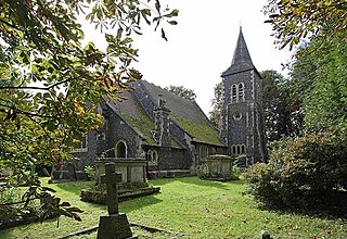
Abinger is a large, well-wooded and mostly rural civil parish that lies between the settlements of Dorking, Shere and Ewhurst in the district of Mole Valley, Surrey, England.

<span class="mw-page-title-main">Betchworth</span> Human settlement in England

Betchworth is a village and civil parish in the Mole Valley district of Surrey, England. The village centre is on the north bank of the River Mole and south of the A25 road, almost 3 miles (4.8 km) east of Dorking and 3 miles (4.8 km) west of Reigate. London is 19.5 miles (31.4 km) north of the village.

Bumpstead was a rural district in the administrative county of Essex, England from 1894 to 1934.

<span class="mw-page-title-main">Moot hall</span> British meeting or assembly building for local issues

A moot hall is a meeting or assembly building, traditionally to decide local issues.

<span class="mw-page-title-main">Helions Bumpstead</span> Human settlement in England

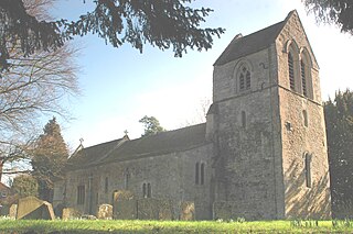
Helions Bumpstead is a small village in Essex located near Haverhill and the meeting-point of the Essex, Suffolk and Cambridgeshire borders. It is 2 miles from Steeple Bumpstead. Helions Bumpstead has "the greens"; Pale Green, Wiggens Green, and Drapers Green. There are four roads into and out of the village; they are Mill Road, Water Lane, Sages End Road and Camps Road. The centre of the village is marked by the crossroads and village green. There is also a meadow with a pond in the centre of the village.

<span class="mw-page-title-main">Steeple Bumpstead</span> Human settlement in England

Steeple Bumpstead is a village and civil parish 3 miles (4.8 km) south of Haverhill in Braintree district, Essex, England.

<span class="mw-page-title-main">Maiden Bradley</span> Human settlement in England

Maiden Bradley is a village in south-west Wiltshire, England, about 6 miles (10 km) south-west of Warminster and bordering the county of Somerset. The B3092 road between Frome and Mere forms the village street. Bradley House, the seat of the Duke of Somerset, is adjacent to the village.

<span class="mw-page-title-main">Matching, Essex</span> Human settlement in England

Matching is a village and civil parish in the Epping Forest district of Essex, England centred in countryside 3 miles (4.8 km) east of Harlow's modern town centre and 2 miles (3.2 km) from Old Harlow/Harlow Mills area of the town. The terrain is elevated and London is centred 21.7 miles (34.9 km) to the south-west.

<span class="mw-page-title-main">Holton le Moor</span> Small village and civil parish in the West Lindsey district of Lincolnshire, England

Holton le Moor is a small village and civil parish in the West Lindsey district of Lincolnshire, England.

<span class="mw-page-title-main">Shelley, Essex</span> Human settlement in England

Shelley is a partly rural village and partly residential conurbation in the Ongar civil parish of the Epping Forest district of Essex, England.

<span class="mw-page-title-main">Rickling, Essex</span> Human settlement in England

Rickling is a village and former civil parish, now in the parish of Quendon and Rickling, in the Uttlesford district of Essex, England. The village is situated approximately 6 miles (10 km) north from the town of Bishop's Stortford. Saffron Walden, at 5 miles (8 km), and the larger village of Newport, at 2 miles (3 km), lie to the north-east. In 1931 the parish had a population of 378.

<span class="mw-page-title-main">Over Worton</span> Human settlement in England

Over Worton is a hamlet in Oxfordshire, about 7 miles (11 km) south of Banbury and 7+12 miles (12 km) east of Chipping Norton. Over Worton was a separate civil parish until 1932, when it was merged with Nether Worton to form the current civil parish of Worton.

<span class="mw-page-title-main">Moot Hall, St Albans</span> Municipal building in St Albans, England

The Moot Hall is a former municipal building in the Market Place in St Albans, Hertfordshire, England. The building, which now operates as two shops with office space above, is a Grade II listed building.

References

  1. 1 2 3 Historic England. "The Moot Hall (1146551)". National Heritage List for England . Retrieved 9 April 2023.
  2. "Suffolk Landscape Character Assessment" (PDF). The Stour Valley Landscape Partnership. p. 43. Retrieved 9 April 2023.
  3. "An exterior view of The Old School House/The Moot Hall, c. 1592 in Steeple Bumpstead". Historic England. Retrieved 9 April 2023.
  4. Bettley, James; Pevsner, Nikolaus. Essex (Buildings of England Series). Yale University Press. p. 749. ISBN   978-0300116144.
  5. "History". St Mary's Church, Steeple Bumpford. Retrieved 9 April 2023.
  6. "History". Steeple Bumpstead Parish Council. Retrieved 9 April 2023.
  7. Robinson, Ben (2021). England's Villages An Extraordinary Journey Through Time. Blink Publishing. ISBN   978-1786580917.
  8. "The Hundred Parishes An introduction to Steeple Bumpstead" (PDF). The Hundred Parishes Society. p. 2. Retrieved 9 April 2023.
  9. Historic England. "Steeple Bumpstead War Memorial (1452736)". National Heritage List for England . Retrieved 9 April 2023.
  10. "Steeple Bumpstead War Memorial". War Memorials Online. Retrieved 9 April 2023.
  11. "Steeple Bumpstead war memorial restored to former glory". Halstead Gazette. 24 October 2018. Retrieved 9 April 2023.
  12. "Griffiths, Joseph (1863–1945)". Royal College of Surgeons of England. Retrieved 9 April 2023.
  13. "Steeple Bumpstead". Open Domesday. Retrieved 9 April 2023.
  14. "Place name: Steeple Bumpstead, Essex Folio: 102r Little Domesday Book". National Archives. Retrieved 9 April 2023.
  15. "Steeple Bumpstead". Domesday Book. Retrieved 9 April 2023.