
Salinas is a municipality in the southern part of Puerto Rico (U.S.) located in the southern coast of the island, south of Aibonito and Cayey; southeast of Coamo, east of Santa Isabel; and west of Guayama. Salinas is spread over 5 wards and Salinas Pueblo.

Ceiba is both a small town and municipality in northeast Puerto Rico (U.S.). It is named after the famous Ceiba tree. Ceiba is located in the north-east coast of the island, bordering the Atlantic Ocean, south of Fajardo, north of Naguabo and southeast of Río Grande. Located about one hour's driving distance from San Juan, Ceiba is spread over 7 wards and Ceiba Pueblo. It is part of the Fajardo Metropolitan Statistical Area.

Hormigueros is a municipality of Puerto Rico (U.S.A.) located in the western region of the island, northeast of Cabo Rojo; northwest of San Germán; and south of Mayagüez. Hormigueros is spread over 5 wards and Hormigueros Pueblo. It is part of the Mayagüez Metropolitan Statistical Area.

Patillas is a municipality of Puerto Rico (U.S.) located in the southeastern coast, south of San Lorenzo; west of Yabucoa and Maunabo; and east of Guayama and Arroyo. It is spread over 15 wards and Patillas Pueblo. It is part of the Guayama Metropolitan Statistical Area.

José María Córdova International Airport is the second largest airport in Colombia after El Dorado International Airport of Bogotá in terms of infrastructure and passenger service. It is located in the city of Rionegro, 20 kilometres (12 mi) south-east of Medellín.

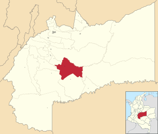
Puerto Boyacá is a Colombian river-port town and municipality by the Magdalena River in the Boyacá Department, where is also considered a Special Handling Zone due to its port status. Its main industries are oil exploration and processing. In the 1980s and early 1990s, Puerto Boyacá was affected intensively by the Colombian Armed Conflict.

Puerto Berrío is a municipality and town in the Colombian department of Antioquia.

Puerto Bolívar Airport is a private airport in the Guajira Department of Colombia. The closest city is Uribia. It is located next to the Cerrejón coal terminal and only serves the workers of the area. Only private sector aircraft and Colombia's Aerocivil land at Puerto Bolivar. No commercial airlines serve the airport and it is mostly empty.
Puerto Lleras is a town and municipality in the Meta Department, Colombia.

Magdalena Medio Antioquia is a subregion in the Colombian Department of Antioquia. The region is made up by 6 municipalities. The region is determined by its location within the Middle Magdalena Region which covers the central area of the Magdalena River basin.
Tres de Mayo Airport is an airport serving the town of Puerto Asís in the Putumayo District of Colombia.
Germán Olano Airport is an airport serving Puerto Carreño, the capital of Vichada Department in Colombia. It is also known as Puerto Carreño Airport. The airport is 1.5 kilometres (0.93 mi) west of and parallels the Orinoco River, locally Colombia's border with Venezuela.
César Gaviria Trujillo Airport is an airport serving the town of Inírida in the Guainía Department of Colombia. The airport is named in honor of César Gaviria Trujillo, a former President of Colombia and Secretary General of the Organization of American States.
Caucayá Airport is an airport serving the river town of Puerto Leguízamo in the Putumayo Department of Colombia. Puerto Leguízamo is on the Putumayo River, locally the border with Peru.

Cacique Aramare Airport is an airport serving Puerto Ayacucho, the capital of the Amazonas state in Venezuela. The airport and city are on the Orinoco River, locally the border between Venezuela and Colombia.
Araracuara Airport is an airport serving Araracuara, in the Caquetá Department of Colombia. Araracuara was the site of a former penal colony for Colombia’s worst and most dangerous criminals.
Puerto Páez Airport is an airport serving the border town of Puerto Páez in the Apure state of Venezuela.
Puerto Nare Airport is an airport serving the river town of Puerto Nare in the Antioquia Department of Colombia.
Puerto Gaitán Airport is an airport serving the river town of Puerto Gaitán in the Meta Department of Colombia.
Velasquez Airport is an airport serving the Magdalena River town of Puerto Boyacá in the Boyacá Department of Colombia. The runway is in the country 13 kilometres (8.1 mi) east of Puerto Boyacá.


