| Morne la Vigie | |
|---|---|
 Morne la Vigie | |
| Highest point | |
| Elevation | 2,276 ft (694 m) |
| Coordinates | 18°47′N72°17′W / 18.78°N 72.28°W |
| Geography | |
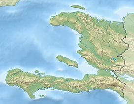
| Location | Saut-d'Eau, Centre, Haiti |
| Geology | |
| Rock age | 1.5 |
| Mountain type | Cinder cone |
| Last eruption | around 400,000 years |
Morne la Vigie is an extinct scoria cone, located 9.4 km from the commune of Saut-d'Eau and 21 km from Port-au-Prince, it was active from Pleistocene until around the 400,000 years ago. [1]