
Chenango Forks is a hamlet located in Broome County, New York in the United States. The community is partly in the town of Chenango and partly in the town of Barker.

Watson Mill Bridge State Park is a 1,018 acre (4.12 km²) Georgia state park located near Comer and Carlton on the South Fork of the Broad River. The park is named for the Watson Mill Bridge, the longest original-site covered bridge in Georgia, which spans 229 feet across the South Fork River. The site is listed on the National Register of Historic Places as the Watson Mill Covered Bridge and Mill Historic District. The bridge, being more than 100 years old, is supported by a town lattice truss system held firmly together with wooden pins. Georgia once had over 200 covered bridges, but only 20 now remain. The park also offers a scenic nature trail and a new hiking/horse trail that winds through the thick forests and along the rivers edge.

Dinwiddie is a small unincorporated community and the county seat of Dinwiddie County, Virginia, United States.
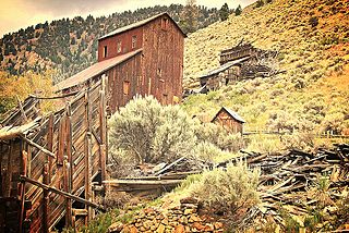
Bayhorse is a ghost town in Custer County, Idaho, United States, founded in 1877. After a new gold mine failed, silver was discovered in the area and a mine was started. Bayhorse was originally established by the silver mine.

Stotlers Crossroads is a small unincorporated community hamlet in southeastern Morgan County, West Virginia. It is situated along Winchester Grade Road between the South and Middle Forks of Sleepy Creek on the eastern flanks of Highland Ridge.

This is a list of properties and districts listed on the National Register of Historic Places in New Jersey. There are more than 1,700 listed sites in New Jersey. All 21 counties in New Jersey have listings on the National Register.

Seneca Rocks is an unincorporated community located in Pendleton County, West Virginia, United States. The community of Seneca Rocks — formerly known as Mouth of Seneca — lies at the junction of US 33, WV 28 and WV 55 near the confluence of Seneca Creek and the North Fork South Branch Potomac River. The community also lies near Seneca Rocks, the crag from which it takes its name. Both lie within the Spruce Knob-Seneca Rocks National Recreation Area of the Monongahela National Forest.

Overbrook Farms is a neighborhood on the western edge of the West Philadelphia section of Philadelphia, Pennsylvania, United States. It is roughly bounded by City Avenue, 58th Street, Woodbine Avenue, and 66th Street at Morris Park. The neighborhood is bisected by Lancaster Avenue and the original Pennsylvania Railroad "main line". Today the rail line is used by both Amtrak passenger service and SEPTA's commuter Paoli/Thorndale Line.

Prices Fork is a small traditionally agricultural census-designated place (CDP), in Montgomery County, Virginia, United States. The population as of the 2010 Census was 1,066. It is located about three miles west of Blacksburg and the campus of Virginia Polytechnic Institute and State University.

Fork Union is an unincorporated community in southern Fluvanna County, Virginia, along U.S. Highway 15. Its ZIP code is 23055; the population within that ZIP code was 1148 according to the 2000 Census. It is known mainly as the home of Fork Union Military Academy, Fork Union Animal Clinic and formerly had one of the few surviving drive-in theatres in Virginia. Fork Union is also home to a post office, a bank, a small grocery store, an IGA, and a Dollar General. The town also includes two independently-owned restaurants: Sal's Pizza and The Village Restaurant. The Village of Fork Union is the location of Fluvanna County's only Presbyterian congregation, Fork Union Presbyterian Church. The James River is just a few miles from Fork Union.
Center Point is an unincorporated community in northeastern Doddridge County, West Virginia, USA. It lies along Route 23 northeast of the town of West Union, the county seat of Doddridge County. Its elevation is 791 feet (241 m).

This is a list of the National Register of Historic Places listings in Grand Forks County, North Dakota. This is intended to be a complete list of the properties and districts on the National Register of Historic Places in Grand Forks County, North Dakota, United States. The locations of National Register properties and districts for which the latitude and longitude coordinates are included below, may be seen in a Bing or Google map.

Custer is a ghost town in Custer County, Idaho, United States. Established in 1877, it is at 44°23′15″N114°41′45″W, at an elevation of 6,470 feet (1,972 m). It lies along Yankee Fork Road southwest of the city of Challis, within the Challis National Forest.

The Crawford Covered Bridge is a historic Queen post truss covered bridge in West Finley, Pennsylvania. The 11'7" by 39' bridge has high sidewalls, a roof made of sheet metal, and crosswise planking. It is open to traffic across the Robinson Fork of Wheeling Creek.
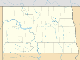
Kempton is an unincorporated community in Grand Forks County, North Dakota, United States. It is located northwest of Northwood, North Dakota. It is the location of the Carlott Funseth Round Barn, which is listed on the National Register of Historic Places.

Coon Box is an unincorporated community located in Jefferson County, Mississippi, United States. Coon Box is 5.9 miles (9.5 km) north of Fayette. The Coon Box Fork Bridge, which is listed on the National Register of Historic Places, is located one mile southwest of Coon Box.

This is a list of the National Register of Historic Places listings in Morris County, Texas.

Bell's Fork is an unincorporated community in Pitt County, North Carolina, United States. Bell's Fork is located on North Carolina Highway 43 at the southeast border of Greenville.
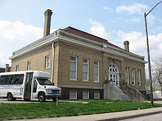
Hawthorne Branch Library No. 2, also known as Hawthorne Education Annex, is a historic Carnegie library building located in Indianapolis, Marion County, Indiana. Built in 1909-1911, with funds provided by the Carnegie Foundation, it is a one-story, rectangular, Classical Revival style brick and limestone building on a raised basement. It has a truncated hipped roof and features a slightly projecting pavilion housing a round arch. It was renovated in 1955, after its closure as a library, and again in 1999.

The Bowman Lake Road was listed on the National Register of Historic Places in 1996. It was deemed significant " for its association with federal development of the North Fork region.... The site's period of significance extends from construction in 1914, when park officials began concerted efforts to develop the Bowman Lake area as part of its fire-control and recreation-development programs, until the end of the historic period as defined by the National Register (1945)."


