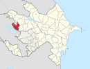
Coordinates: 40°44′N45°48′E / 40.733°N 45.800°E
A geographic coordinate system is a coordinate system that enables every location on Earth to be specified by a set of numbers, letters or symbols. The coordinates are often chosen such that one of the numbers represents a vertical position and two or three of the numbers represent a horizontal position; alternatively, a geographic position may be expressed in a combined three-dimensional Cartesian vector. A common choice of coordinates is latitude, longitude and elevation. To specify a location on a plane requires a map projection.
Moruxlu | |
---|---|
Coordinates: 40°44′N45°48′E / 40.733°N 45.800°E | |
Country | |
Rayon | Gadabay |
Municipality | Samanlıq |
Time zone | AZT (UTC+4) |
• Summer (DST) | AZT (UTC+5) |
Moruxlu (also, Morukhlu) is a village in the Gadabay Rayon of Azerbaijan. The village forms part of the municipality of Samanlıq. [1]
Azerbaijan, officially the Republic of Azerbaijan, is a country in the South Caucasus region of Eurasia at the crossroads of Eastern Europe and Western Asia. It is bounded by the Caspian Sea to the east, Russia to the north, Georgia to the northwest, Armenia to the west and Iran to the south. The exclave of Nakhchivan is bounded by Armenia to the north and east, Iran to the south and west, and has an 11 km long border with Turkey in the northwest.
Samanlıq is a village and municipality in the Gadabay Rayon of Azerbaijan. It has a population of 1,824. The municipality consists of the villages of Samanlıq, Moruxlu, and Rəmə.
In 2000, it incorporated the nearby village of Tərs yer. [2]
Xatman is a village in the Agsu Rayon of Azerbaijan. The village forms part of the municipality of Dilman.
Hacıman is a village in the Agsu Rayon of Azerbaijan. The village forms part of the municipality of Dilman.
Eyvazallar is a village in the Beylagan Rayon of Azerbaijan.
Sarıhəsənli is a village in the Gadabay Rayon of Azerbaijan. The village forms part of the municipality of Şəkərbəy.
Göynüyən is a village in the Goranboy Rayon of Azerbaijan. The village forms part of the municipality of Hazırəhmədli.
Kürd is a village in the Goychay Rayon of Azerbaijan. The village forms part of the municipality of Potu.
Yuxarı Apu is a village in the Lankaran Rayon of Azerbaijan. The village forms part of the municipality of Daştatük.
Ağdərə is a village in the Tovuz Rayon of Azerbaijan. The village forms part of the municipality of İsakənd.
Səmədbəyli is a village in the Tovuz Rayon of Azerbaijan.
Gödəkdərə is a village in the Gadabay Rayon of Azerbaijan. The village forms part of the municipality of Şəkərbəy.
Sərsurə is a village in the Ismailli Rayon of Azerbaijan. The village forms part of the municipality of Sulut.
Yenikənd is a village in the Gadabay Rayon of Azerbaijan. The village forms part of the municipality of Gərgər.
Hacılar is a village in the Tovuz Rayon of Azerbaijan.
Pərizamanlı is a village and the least populous municipality in the Gadabay Rayon of Azerbaijan. It has a population of 667.
Totuqlu is a village in the municipality of Qoşabulaq in the Gadabay Rayon of Azerbaijan.
Ayıtala is a village in the municipality of Düzyurd in the Gadabay Rayon of Azerbaijan.
Aşkar is a village in the municipality of Quşçu in the Shamakhi Rayon of Azerbaijan.
Namxoş is a village in the municipality of Çobansığnaq in the Tovuz Rayon of Azerbaijan.
Avdal is a village in the municipality of Əhmədabad in the Tovuz Rayon of Azerbaijan.
Qarabağlılar is a village in the municipality of İsakənd in the Tovuz Rayon of Azerbaijan.
This Gadabay Rayon location article is a stub. You can help Wikipedia by expanding it. |