Johnsville, also known as Shauck, is an unincorporated community in northern Perry Township, Morrow County, Ohio, United States. Although it is unincorporated, it has a post office, with the ZIP code of 43349. It is located at the intersection of U.S. Route 42 with State Route 314.
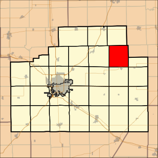
Lawndale Township is located in McLean County, Illinois, east of Lexington, northwest of Colfax, and southeast of Chenoa. As of the 2010 census, its population was 158 and it contained 74 housing units. Lawndale Cemetery is located on 2550 North Road. At least part of the township is within the area of the proposed Lexington Chenoa Wind Farm to be developed by Horizon Wind Energy.

Roseville Township is located in Warren County, Illinois, United States. As of the 2010 census, its population was 1,213 and it contained 578 housing units.

The Giardino Botanico Fondazione André Heller, also known as the Giardino Botanico A. Hruska, is a botanical garden located on the grounds of the André Heller Foundation above Lake Garda, in via Roma, Gardone Riviera, Province of Brescia, Lombardy, Italy. It is open daily in the warmer months.

Kamieniec is a village in the administrative district of Gmina Topólka, within Radziejów County, Kuyavian-Pomeranian Voivodeship, in north-central Poland. It lies approximately 7 kilometres (4 mi) south of Topólka, 22 km (14 mi) south-east of Radziejów, and 64 km (40 mi) south of Toruń.

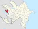
Danayeri is a village in the Goygol Rayon of Azerbaijan. The village forms part of the municipality of Qızılca.
Uludyuz is a village in the Lachin Rayon of Azerbaijan.
Beniaminów is a village in the administrative district of Gmina Zduńska Wola, within Zduńska Wola County, Łódź Voivodeship, in central Poland. It lies approximately 3 kilometres (2 mi) north-west of Zduńska Wola and 40 km (25 mi) south-west of the regional capital Łódź.
Siedlisko is a village in the administrative district of Gmina Zgierz, within Zgierz County, Łódź Voivodeship, in central Poland. It lies approximately 6 kilometres (4 mi) north-east of Zgierz and 12 km (7 mi) north of the regional capital Łódź.
Dębiany is a village in the administrative district of Gmina Obrazów, within Sandomierz County, Świętokrzyskie Voivodeship, in south-central Poland. It lies approximately 2 kilometres (1 mi) south-west of Obrazów, 10 km (6 mi) west of Sandomierz, and 75 km (47 mi) east of the regional capital Kielce.

Czarna Dąbrowa is a village in Gmina Studzienice, Bytów County, Pomeranian Voivodeship, in northern Poland. It lies approximately 9 kilometres (6 mi) south-east of Bytów and 71 km (44 mi) south-west of Gdańsk.
Smaszków is a village in the administrative district of Gmina Błaszki, within Sieradz County, Łódź Voivodeship, in central Poland. It lies approximately 3 kilometres (2 mi) east of Błaszki, 21 km (13 mi) west of Sieradz, and 71 km (44 mi) west of the regional capital Łódź.

Pogórze is a village in the administrative district of Gmina Biała, within Prudnik County, Opole Voivodeship, in south-western Poland. It lies approximately 8 kilometres (5 mi) north of Biała Prudnicka, 18 km (11 mi) north-east of Prudnik, and 28 km (17 mi) south-west of the regional capital Opole.
Mąkowo is a settlement in the administrative district of Gmina Człuchów, within Człuchów County, Pomeranian Voivodeship, in northern Poland.
Ābeļi Parish is an administrative unit of Jēkabpils Municipality, Latvia.

The Château de Cordon is a ruined feudal castle in the commune of Brégnier-Cordon in the Ain département of France.
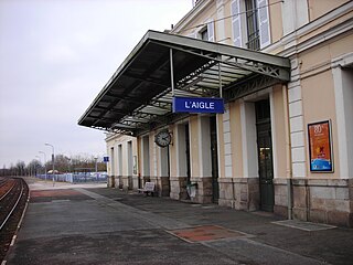
Gare de L'Aigle is a railway station serving the town L'Aigle, Orne department, northwestern France.
Liivaküla is a village in Ridala Parish, Lääne County, in western Estonia.

Winnemucca Air Force Station is a closed United States Air Force General Surveillance Radar station. It is located 3.1 miles (5.0 km) north-northwest of Winnemucca, Nevada. It was closed in 1968.
Kot Lakhpat is a neighbourhood and union council of Gulberg Tehsil in Lahore, Punjab, Pakistan. The neighbourhood is both a residential and industrial area. It is located at 31° 27' 57N 74° 20' 14E. Kot Lakhpat is bordered by the Defence to the east and Township to the west. Kot Lakhpat railway station, Lahore Race Club, Quaid-e-Azam Industrial Estate and Central Jail Lahore are situated in this neighbourhood.