Sers, is a village in the Vayots Dzor Province of Armenia.

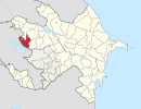
Böyük Qaramurad is a village and municipality in the Gadabay Rayon of Azerbaijan. It has a population of 2,684. The municipality consists of the villages of Böyük Qaramurad, Ataxal, Qurudərə, and Toplar.

Fərzalı is a village in the Gadabay Rayon of Azerbaijan. The village forms part of the municipality of Arabaçı.

Məşədivəlilər is a village in the Tovuz Rayon of Azerbaijan. The village forms part of the municipality of Həsənli.

Aşralar is a village in the Tovuz Rayon of Azerbaijan. The village forms part of the municipality of İsakənd.

Güvəndik is a village in the Tovuz Rayon of Azerbaijan. The village forms part of the municipality of Papaqçılar.

Cirdək is a village in the Tovuz Rayon of Azerbaijan. The village forms part of the municipality of Çatax.

Məşədiqulular is a village in the Tovuz Rayon of Azerbaijan. The village forms part of the municipality of Göyəbaxan.

Haliszka is a village in the administrative district of Gmina Iwaniska, within Opatów County, Świętokrzyskie Voivodeship, in north-central Poland. It lies approximately 3 kilometres (2 mi) south-east of Iwaniska, 14 km (9 mi) south-west of Opatów, and 52 km (32 mi) east of the regional capital Kielce.
Qurudərə or Kurudere is a Turkic word meaning "dry creek" and may refer to:

Günəşli is a village in the Gadabay Rayon of Azerbaijan. The village forms part of the municipality of Dəyəqarabulaq.

Maarif is a village in the Gadabay Rayon of Azerbaijan. The village forms part of the municipality of Slavyanka.

Strochcice is a village in the administrative district of Gmina Samborzec, within Sandomierz County, Świętokrzyskie Voivodeship, in south-central Poland. It lies approximately 5 kilometres (3 mi) north-east of Samborzec, 3 km (2 mi) south-west of Sandomierz, and 82 km (51 mi) east of the regional capital Kielce.

Wólka Kadłubska is a village in the administrative district of Gmina Radzanów, within Białobrzegi County, Masovian Voivodeship, in east-central Poland. It lies approximately 5 kilometres (3 mi) east of Radzanów, 11 km (7 mi) south of Białobrzegi, and 73 km (45 mi) south of Warsaw.
Papaqçılar is a village and municipality in the Tovuz Rayon of Azerbaijan. It has a population of 1,387. The municipality consists of the villages of Papaqçılar and Güvəndik.
Qarabağlılar is a village in the municipality of İsakənd in the Tovuz Rayon of Azerbaijan.

Golubie is a village in the administrative district of Gmina Dubeninki, within Gołdap County, Warmian-Masurian Voivodeship, in northern Poland, close to the border with the Kaliningrad Oblast of Russia. It lies approximately 10 kilometres (6 mi) east of Dubeninki, 27 km (17 mi) east of Gołdap, and 156 km (97 mi) east of the regional capital Olsztyn.

Gajewko is a village in the administrative district of Gmina Drawsko Pomorskie, within Drawsko County, West Pomeranian Voivodeship, in north-western Poland. It lies approximately 5 kilometres (3 mi) north-west of Drawsko Pomorskie and 80 km (50 mi) east of the regional capital Szczecin.

Błotny Młyn is a village in the administrative district of Gmina Nowogard, within Goleniów County, West Pomeranian Voivodeship, in north-western Poland. It lies approximately 8 kilometres (5 mi) north-west of Nowogard, 24 km (15 mi) north-east of Goleniów, and 45 km (28 mi) north-east of the regional capital Szczecin.

Arisa Station is a railway station of Kyushu Railway Company located in Yatsushiro, Kumamoto, Japan.


