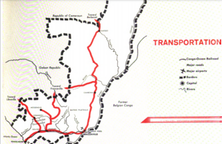
Transport in the Republic of Congo includes land, air and water modes. Over 3,000 km (1,900 mi) of paved roads are in use. The two international airports are Maya-Maya Airport and Pointe Noire Airport.
Transport in Tanzania includes road, rail, air and maritime networks. The road network is 86,472 kilometres (53,731 mi) long, of which 12,786 kilometres (7,945 mi) is classified as trunk road and 21,105 kilometres (13,114 mi) as regional road. The rail network consists of 3,682 kilometres (2,288 mi) of track. Commuter rail service is in Dar es Salaam only. There are 28 airports, with Julius Nyerere International being the largest and the busiest. Ferries connect Mainland Tanzania with the islands of Zanzibar. Several other ferries are active on the countries' rivers and lakes.

Brazzaville is the capital and largest city of the Republic of the Congo. Administratively, it is a department and a commune. Constituting the financial and administrative centre of the country, it is located on the north side of the Congo River, opposite Kinshasa, the capital city of the Democratic Republic of the Congo.

Limeira is a city in the eastern part of the Brazilian state of São Paulo. With a population of approximately 291,869 people and covering an area of 581 square kilometers, it sits at an elevation of 588 meters. The city is situated 154 kilometers from São Paulo, the capital of the state, and 1011 kilometers from Brasilia, the capital of Brazil. Limeira is conveniently accessible from São Paulo via two highways: Rodovia Anhanguera and Rodovia dos Bandeirantes.

Palghar is a prominent town in the Konkan division of Maharashtra state, India, and a municipal council. It is Strategically located within the Mumbai Metropolitan Region, and since 2014, it has been the administrative capital of the Palghar district. Palghar plays a crucial role in Western Line of the Mumbai Suburban Railway in the busy Mumbai-Ahmedabad rail corridor. The town is located approximately 87 kilometers north of Mumbai, about 35 kilometers north of Virar, and about 24 kilometers west of the Mumbai-Ahmedabad National Highway at Manor and Mumbai is approximately 50+ km from Palghar.

Niari is a department of the Republic of the Congo in the western part of the country. It borders the departments of Bouenza, Kouilou, and Lékoumou, and internationally, Gabon, the Democratic Republic of the Congo, and the Cabinda portion of Angola. The regional capital is Dolisie.

Pointe-Noire is the second largest city in the Republic of the Congo, following the capital of Brazzaville, and an autonomous department and a commune since the 2002 Constitution. Before this date it was the capital of the Kouilou region. It is situated on a headland between Pointe-Noire Bay and the Atlantic Ocean. Pointe-Noire is the main commercial centre of the country and has a population of 1,420,612 inhabitants in 2023.

Kayes is a city in western Mali on the Sénégal River with a population of 127,368 at the 2009 census. Kayes is the capital of the administrative region of the same name. The name "Kayes" comes from the Soninke word "karré", which describes a low humid place that floods in rainy season. The city is located 420 kilometres (260 mi) northwest of the capital Bamako.

Ndola is the third largest city in Zambia in terms of size and population, with a population of 627,503, after the capital, Lusaka, and Kitwe, and the second largest in terms of infrastructure development after Lusaka. It is the industrial and commercial center of the Copperbelt, Zambia's copper-mining region, and capital of Copperbelt Province. It lies just 10 kilometres (6.2 mi) from the border with DR Congo. It is also home to Zambia's first modern stadium, the Levy Mwanawasa Stadium.

Moanda is one of the largest towns in Gabon, lying on the N3 road in Haut Ogooué. It is also one of the most important manganese mining towns in the world, under the auspices of the Compagnie Minière de l'Ogooué (COMILOG), which began mining in 1957. Moanda has a population of around 39,298 inhabitants and is the second largest city in the Haut Ogooué Region, after Franceville. It is also a border town, lying 100 km away from the border with the Republic of Congo.

Dolisie, known as Loubomo between 1975 and 1991, is a city and a commune. It is the capital of Niari in the south western of the Republic of the Congo, the country's third largest city and an important commercial centre. The city lies on the eastern edge of the coastal rainforest and has a population of 178,172.
Nkayi, also known as N'kayi, is a town and a commune in the Bouenza Department of the Republic of the Congo. It is the country's fourth largest city with a population of 104,083.

The Departments of the Republic of the Congo are divided into 86 districts and 6 communes; which are further subdivided into urban communities and rural communities ; which are further subdivided into quarters or neighborhoods (quartiers) and villages. Note the departments of Brazzaville and Pointe-Noire are made of 1 commune each, then divided in urban districts (arrondissements).
The Tripoli–Cape Town Highway or TAH 3 is Trans-African Highway 3 in the transcontinental road network being developed by the United Nations Economic Commission for Africa (UNECA), the African Development Bank (AfDB), and the African Union. The route has a length of 10,808 km (6,716 mi) and has the longest missing links and requires the most new road construction.

Mayoko District is a district in the Niari Department of south-western Republic of the Congo. The capital lies at Mayoko. It has a northern border with Gabon. As of 2007, the population is 5,147.
Railway stations in the Republic of the Congo (Congo) include:
Mayoko is a town in the Mayoko District, Niari Department, east of the Republic of the Congo.

Rail transport in Azerbaijan is operated by the national state-owned railway company Azerbaijan Railways. The railway network consists of 2,918 km (1,813 mi), its gauge is 1,520 mm, 815 km (506 mi) are double track and 1,272 km (790 mi) are electrified at 3 kV (3,000 V) DC.

The Central Business District of Belapur is a large upmarket neighbourhood of Navi Mumbai. The Navi Mumbai Municipal Corporation is headquartered in Belapur. The Reserve Bank of India maintains a branch office at CBD Belapur. This area is one of the fastest developing regions in Navi Mumbai in terms of new residential and commercial construction projects. CBD Belapur is connected to other parts of Mumbai through railways, BEST & NMMT buses. It had a ferry service for traveling to Elephanta caves from Sector-11.

Oil and gas dominate the extraction industries of the Republic of the Congo, also referred to as Congo-Brazzaville. The petroleum industry accounted for 89% of the country’s exports in 2010. Among African crude oil producers in 2010, The Congo ranked seventh. Nearly all of the country's hydrocarbons were produced off-shore. The minerals sector is administered by the Department of Mines and Geology. Presently no major mining activities are underway, although there are some small-scale domestic operations. However, the country does have numerous large-scale undeveloped resources. The country has recently attracted a strong influx of international companies seeking to tap into the vast mineral wealth.


