Djibouti is a country in the Horn of Africa bordered by Somalia to the east, Eritrea to west and the Red Sea to the north, Ethiopia to the west and south, and the Gulf of Aden to the east.

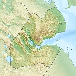
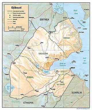
Djibouti is a country in the Horn of Africa. It is bordered by Eritrea in the north, Ethiopia in the west and south, and Somalia in the southeast. To the east is its coastline on the Red Sea and the Gulf of Aden. Rainfall is sparse, and most of the territory has a semi-arid to arid environment. Lake Assal is a saline lake which lies 155 m (509 ft) below sea level, making it the lowest point on land in Africa and the third-lowest point on Earth after the Sea of Galilee and the Dead Sea. Djibouti has the fifth smallest population in Africa. Djibouti's major settlements include the capital Djibouti City, the port towns of Tadjoura and Obock, and the southern cities of Ali Sabieh and Dikhil. It is the forty-six country by area in Africa and 147st largest country in the world by land area, covering a total of 23,200 km2 (9,000 sq mi), of which 23,180 km2 (8,950 sq mi) is land and 20 km2 (7.7 sq mi) is water.

The Gulf of Aden is a deepwater gulf of the Indian Ocean between Yemen to the north, the Arabian Sea to the east, Djibouti to the west, and the Guardafui Channel, the Socotra Archipelago, Puntland in Somalia and Somaliland to the south. In the northwest, it connects with the Red Sea through the Bab-el-Mandeb strait, and it connects with the Arabian Sea to the east. To the west, it narrows into the Gulf of Tadjoura in Djibouti. The Aden Ridge lies along the middle of the gulf, and tectonic activity at the ridge is causing the gulf to widen by about 15 mm (0.59 in) per year.

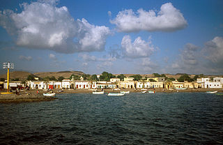
Obock is a small port town in Djibouti. It is located on the northern shore of the Gulf of Tadjoura, where it opens out into the Gulf of Aden. The town is home to an airstrip and has ferries to Djibouti City. The French form Obock derives from Arabic "Oboh", which is a deformation of Oboki, a name given to a local wadi.

The Tadjourah Region Somali: Gobolka Tajoora, Afar: Rakaakay Tagórri) is a region in north-central Djibouti, the largest of its six regions. With its capital at Tadjourah, it has an area of 7,100 square kilometres. It lies along the Gulf of Tadjoura, and the coastal city of Tadjoura. The region has active salt and fisheries industries, and is served by the Tadjoura Airport. In total area, it is larger than Brunei and smaller than Cyprus.

The Obock Region is a region in northern Djibouti. It has a land area of 4,700 square kilometres, and had a population of 37,856 in 2009. It lies along the Red Sea, Bab-el-Mandeb, Gulf of Aden, Gulf of Tadjoura and includes the Seven Brothers, Doumeira Islands and the coastal city of Obock. It lies along a portion of the national border with Eritrea. In total area, it is larger than Cape Verde and smaller than Trinidad and Tobago. The topography of the region has highland and coastal plains.
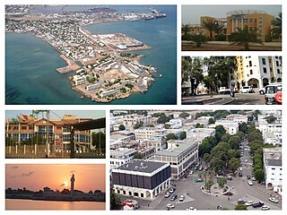
Djibouti is the capital of Djibouti. It is located in the coastal Djibouti Region on the Gulf of Tadjoura.
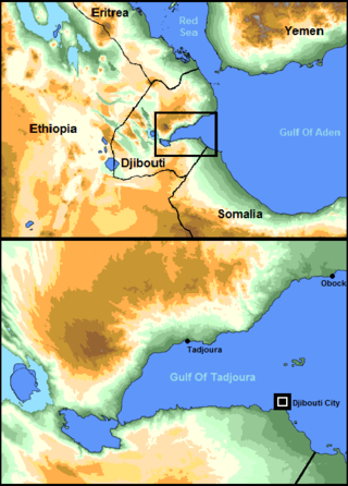
The Gulf of Tadjoura is a gulf or basin of the Indian Ocean in the Horn of Africa. It lies south of the straits of Bab-el-Mandeb, or the entrance to the Red Sea, at 11.7°N 43.0°E. The gulf has many fishing grounds, extensive coral reefs, and abundant pearl oysters. Most of its coastline is the territory of Djibouti, except for a short stretch on the southern shore, which is part of the territory of Somaliland.
Tadjoura is one of the oldest towns in Djibouti and the capital of the Tadjourah Region. The town rose to prominence in the early 19th century as an alterative port to nearby Zeila. Lying on the Gulf of Tadjoura, it is home to a population of around 19,000 inhabitants. It is the third-largest city in the country after Djibouti and Ali Sabieh.
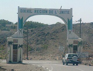
Dikhil is a town in the western Dikhil Region of Djibouti. Lying east of Lake Abbe, It is situated about 122 km (76 mi) southwest of Djibouti City and 12 km (7.5 mi) north of the border with Ethiopia. It serves as the administrative centre of the Dikhil Region, and is home to the Afar and Somali ethnic groups. The town develops gardens and fruit trees.

The Goda Mountains lie northwest of the Gulf of Tadjoura, Tadjoura Region in Djibouti. They rise to 1,750 metres (5,740 ft) above sea level and are the nation's largest heavily vegetated area and is the second highest point in Djibouti. The name Goda in Afar means "twisted" or "devoured" and refers to a ridge. A part of the mountains is protected within the Day Forest National Park, Djibouti's only national park. The ecology of this landform is considered an isolated outlier of the Ethiopian montane grasslands and woodlands ecoregion, an important island of forest in a sea of semi-desert.

Lake Assal is a crater lake in central-western Djibouti. It is located at the western end of Gulf of Tadjoura between Arta Region, and Tadjoura Region, touching Dikhil Region, at the top of the Great Rift Valley, some 120 km (75 mi) west of Djibouti city. Lake Assal is a saline lake that lies 155 m (509 ft) below sea level in the Afar Triangle, making it the lowest point on land in Africa and the third-lowest point on Earth after the Sea of Galilee and the Dead Sea. No outflow occurs from the lake, and due to high evaporation, the salinity level of its waters is 10 times that of the sea, making it the fifth most saline body of water in the world, behind Garabogazköl, Lake Retba, and Gaet'ale Pond. The salt in the lake is exploited under four concessions awarded in 2002 at the southeast end of the lake; the major share of production is held by Société d’Exploitation du Lac and Société d’Exploitation du Salt Investment S.A de Djibouti.
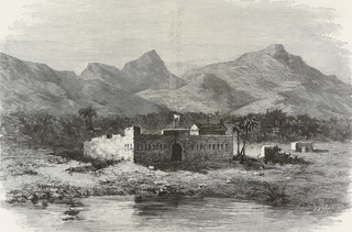
Sagallo is a village situated on the Gulf of Tadjoura, in the country of Djibouti, famous for having been occupied by a Russian monk and adventurer in 1889.
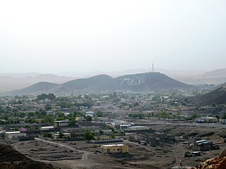
Ali Sabieh is the second largest city in Djibouti. It is situated about 98 kilometres Southwest of Djibouti City and 10 km (6 mi) north of the border with Ethiopia. It sprawls on a wide basin surrounded by granitic mountains on all sides. Ali Sabieh's mild climate makes it a popular tourist destination for Djiboutians. The famous landmark of Ali Sabieh mountain is located near the city.
The wildlife of Djibouti, consisting of its flora and fauna, is in a harsh landscape with forest accounting for less than one percent of its area. Most species are found in the northern part of the country in the Day Forest National Park at an average elevation of 1,500 metres (4,900 ft), including the massif Goda, with a peak of 1,783 metres (5,850 ft). It covers an area of 3.5 square kilometres (1.4 sq mi) of Juniperus procera forest, with many of the trees rising to 20 metres (66 ft) height. This forest area is the main habitat of the critically endangered and endemic Djibouti spurfowl, and another recently noted vertebrate, Platyceps afarensis. The area also contains many species of woody and herbaceous plants, including boxwood and olive trees, which account for sixty percent of the identified species in the country.

As Ela, As Eyla, It is located around 160 kilometres southwest of the capital, Djibouti City and 5 km north of the border with Ethiopia. It is located along the National Highway 6. Tourist richness which the crater formed Lake Abbe, As' Eyla Province is located within the boundaries.

Djibouti Region, also known formerly as Djibouti District, is the capital of the Republic of Djibouti and one of the six regional administrative divisions of the country. With 777,000 residents across a total area of about 80 square miles, Djibouti Region is the most populous in Djibouti. It is the smallest region in Djibouti, and contains the national capital, Djibouti.

Djibouti, officially the Republic of Djibouti, is a country in the Horn of Africa, bordered by Somalia to the south, Ethiopia to the southwest, Eritrea in the north, and the Red Sea and the Gulf of Aden to the east. The country has an area of 23,200 km2 (8,958 sq mi).

Tourism in Djibouti is one of the growing economic sectors of the country and is an industry that generates 53,000 and 73,000 arrivals per year, with its favorable beaches and climate and also including islands and beaches in the Gulf of Tadjoura and the Bab al-Mandab. The main tourist activities are scuba diving, fishing, trekking and hiking, discovering the nomadic way, bird watching, and sun, sea and sand.

The Obock Territory and Dependencies was an administrative colony belonging to the Second French colonial empire, between 1862 and 1896, located in the current republic of Djibouti.
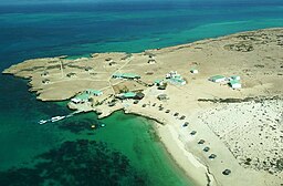
 View on the Moucha Island
 Beach View
 The mangrove swamp of Moucha
 Satellite photo