Sulu, officially the Province of Sulu, is a province of the Philippines in the Sulu Archipelago and part of the Bangsamoro Autonomous Region in Muslim Mindanao (BARMM).

Tawi-Tawi, officially the Province of Tawi-Tawi, is an island province in the Philippines located in the Bangsamoro Autonomous Region in Muslim Mindanao (BARMM). The capital of Tawi-Tawi is Bongao.

The Autonomous Region in Muslim Mindanao was an autonomous region of the Philippines, located in the Mindanao island group of the Philippines, that consisted of five predominantly Muslim provinces: Basilan, Lanao del Sur, Maguindanao, Sulu, and Tawi-Tawi. It was the only region that had its own government. The region's de facto seat of government was Cotabato City, although this self-governing city was outside its jurisdiction.

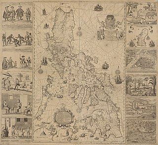
The Sultanate of Sulu was a Sunni Muslim state that ruled the Sulu Archipelago, coastal areas of Zamboanga City and certain portions of Palawan in the today's Philippines, alongside parts of present-day Sabah and North Kalimantan in north-eastern Borneo.

The Tausūg, are an ethnic group of the Philippines and Malaysia. A small population can also be found in the northern part of North Kalimantan, Indonesia. The Tausūg are part of the wider political identity of Muslim Filipinos of western Mindanao, the Sulu archipelago, and southern Palawan, collectively referred to as the Moro people. The Tausugs originally had an independent state known as the Sultanate of Sulu, which once exercised sovereignty over the present day provinces of Basilan, Palawan, Sulu, Tawi-Tawi, Zamboanga City, eastern part of Sabah and eastern part of North Kalimantan. They are also known in the Malay language as Suluk.

Islam in the Philippines is the second largest religion in the country, and the faith was the first-recorded monotheistic religion in the Philippines. Historically, Islam reached the Philippine archipelago in the 14th century, through contact with Muslim Malay and Arab merchants along Southeast Asian trade networks, in addition to Yemeni missionaries from the tribe of Alawi of Yemen from the Persian Gulf, southern India, and their followers from several sultanates in the wider Malay Archipelago. The first missionaries then followed in the late 14th and early 15th centuries. They facilitated the formation of sultanates and conquests in mainland Mindanao and Sulu. Those who converted to Islam came to be known as the Moros, with Muslim conquest reaching as far as Tondo that was later supplanted by Bruneian Empire vassal-state of Maynila.

Jolo is a volcanic island in the southwest Philippines and the primary island of the province of Sulu, on which the capital of the same name is situated. It is located in the Sulu Archipelago, between Borneo and Mindanao, and has a population of approximately 500,000 people.

Jolo, officially the Municipality of Jolo, is a 1st class municipality and capital of the province of Sulu, Philippines. According to the 2020 census, it has a population of 137,266 people.
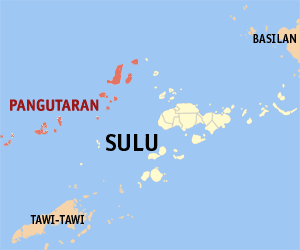
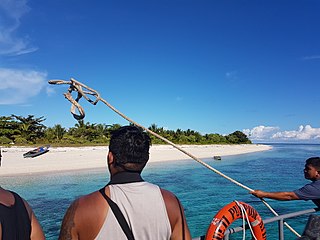
Pangutaran, officially the Municipality of Pangutaran, is a 4th class municipality in the province of Sulu, Philippines. According to the 2020 census, it has a population of 36,374 people.

Bongao, officially the Municipality of Bongao, is a 2nd class municipality and capital of the province of Tawi-Tawi, Philippines. According to the 2020 census, it has a population of 116,118 people.

Sheikh Karimul Makhdum was an Arab Sunni Sufi Muslim as well as a known missionary from Syria who came to Malacca. Karimul Makhdum was born in Makdonia, a village near Damascus in Syria. Him and the Wali sanga were affiliated with the Kubrawi Hamadani missionaries in the late 14th century. He was a Sufi who brought Islam to the Philippines in 1380, 141 years before Portuguese explorer Ferdinand Magellan arrived in the country. He established a mosque in Simunul Island, Tawi Tawi, Philippines, known as Sheik Karimal Makdum Mosque which is the oldest mosque in the country.

The Philippine hawk-owl is a species complex of owls in the genus Ninox. They are all endemic to the Philippines.

The Sheikh Karimul Makhdum Mosque is located in Barangay Tubig Indangan, Simunul, Tawi-Tawi, the Philippines. It is the oldest mosque in the Philippines and in Southeast Asia.
Sanga-Sanga is an island of the Celebes Sea in the southwestern Philippines, bordered to nordwest by the Sulu Sea. The island is part of the Sulu Archipelago. It is sandwiched between Tawitawi Island to the east and Bangao Island to the south.
Mardanas Island is an island in the municipality of Sitangkai, Tawi-Tawi. With an area of 0.1 square kilometres (0.039 sq mi). It is officially known as Siluag in the 1939 Census Atlas of the Philippines, however locals and the Philippine Navy disputes this name. It is one of the last islands of the Sulu Archipelago nearest the Philippine-Malaysian border and is next to Panguan Island.
Andulinang Island is an island in the municipality of Sitangkai, Tawi-Tawi. With an area of 0.02 square kilometres (0.0077 sq mi). It is located at the western edge of the Andulinang Reef. It is one of the last islands of the Sulu Archipelago nearest the Philippine-Malaysian border next to Panguan Island and Mardanas Island.
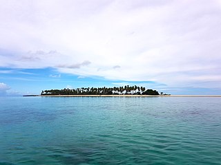
Panampangan Island is an island in the municipality of Sapa-Sapa, Tawi-Tawi. With an area of 0.1 square kilometres (0.039 sq mi). It is located inside Basibuli Shoal, to which its sandbar extends to 3,128.37 metres (10,263.7 ft). It is considered as the longest sandbar in the Philippines and is characterized with fine white sand beach in the Sulu Archipelago.
In the Philippine history, the Lupah Sug was a predecessor state before the establishment of Sultanate of Sulu.
The Sulu Archipelago rain forests ecoregion covers the Sulu Archipelago, excepting Basilan Island at the northern end, in the southwest of the Philippines. The islands are separated enough from Borneo to the south and Mindanao to the north that they have developed their own distinctive floral and faunal communities. Most of the original rainforest has been removed or disturbed for agriculture, and political instability in the islands has hampered conservation efforts.

Bongao Island is one of the islands of the Sulu Archipelago, a chain of islands between Mindanao and Borneo. Bongao Island is the town center of the municipality of Bongao, the capital of the province of Tawi-Tawi, the southernmost province of the Philippines.