Tierra del Fuego is an archipelago off the southernmost tip of the South American mainland, across the Strait of Magellan.

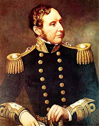
Vice-Admiral Robert FitzRoy was an English officer of the Royal Navy, politician and scientist who served as the second governor of New Zealand between 1843 and 1845. He achieved lasting fame as the captain of HMS Beagle during Charles Darwin's famous voyage, FitzRoy's second expedition to Tierra del Fuego and the Southern Cone.

Tierra del Fuego, officially the Province of Tierra del Fuego, Antarctica and South Atlantic Islands, is the southernmost, smallest, and least populous Argentine province. The provincial capital city is Ushuaia, from a native word meaning "bay towards the end".

Isla Grande de Tierra del Fuego also formerly Isla de Xátiva is an island near the southern tip of South America from which it is separated by the Strait of Magellan. The western portion (61.4%) of the island is in Chile, while the eastern portion is in Argentina. It forms the major landmass in an extended group of islands or archipelago also known as Tierra del Fuego.

Beagle Channel is a strait in the Tierra del Fuego Archipelago, on the extreme southern tip of South America between Chile and Argentina. The channel separates the larger main island of Isla Grande de Tierra del Fuego from various smaller islands including the islands of Picton, Lennox and Nueva; Navarino; Hoste; Londonderry; and Stewart. The channel's eastern area forms part of the border between Chile and Argentina and the western area is entirely within Chile.

Monte Fitz Roy is a mountain in Patagonia, on the border between Argentina and Chile. It is located in the Southern Patagonian Ice Field, near El Chaltén village and Viedma Lake. It was first climbed in 1952 by French alpinists Lionel Terray and Guido Magnone.

Eric Earle Shipton, CBE, was an English Himalayan mountaineer.

The Darwin Sound is an expanse of seawater which forms a westward continuation of the Beagle Channel and links it to the Pacific Ocean at Londonderry Island and Stewart Island, not far from the southern tip of South America. It thus forms a navigable link across Tierra del Fuego between the Pacific and Atlantic Oceans as an alternative to going round the hazardous rocky headland of Cape Horn.

Mount Darwin is a flat-topped mountain in the Sierra Nevada, on the border of between Fresno and Inyo counties in Kings Canyon National Park and the John Muir Wilderness of California.

Navarino Island is a large Chilean island, with an area of 2,514 km2 (971 sq mi) and a coastline of 510 km (320 mi). It is located between Isla Grande de Tierra del Fuego, to the north, and Cape Horn, to the south. The island forms part of the Commune of Cabo de Hornos, the southernmost commune in Chile and in the world, belonging to Antártica Chilena Province in the XII Region of Magallanes and Chilean Antarctica. Its population is concentrated primarily in the communal capital, Puerto Williams, and in small settlements like Puerto Navarino, Río Guanaco and Puerto Toro. The highest point of the island is Pico Navarino at 1,195 m (3,921 ft). The island is a popular destination for fly-fishers.

Alberto de Agostini National Park is a protected area that was created on January 22, 1965, on land that was formerly part of the "Hollanda" forest reserve and "Hernando de Magallanes National Park". It covers 1,460,000 hectares and includes the Cordillera Darwin mountain range, which is the final land-based stretch of the Andes before it becomes a chain of mountains appearing as small islands that sink into the Pacific Ocean and the Beagle Channel.

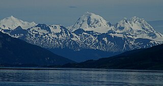
The Cordillera Darwin is an extensive mountain range mantled by an ice field that is located in Chile.

Mount Tarn is a small mountain located on the southernmost part of the Strait of Magellan, in Brunswick Peninsula, about 70 km south of Punta Arenas, Chile. It is in the southern extreme of continental Chile very close to Cape Froward, surrounded by historic places such as Fort Bulnes and Puerto del Hambre.

The Zona Austral is one of the five natural regions into which CORFO divided continental Chile in 1950 corresponding to the Chilean portion of Patagonia. It is surrounded by the Zona Sur and the Chacao Channel to the north, the Pacific Ocean and Drake's Passage to the south and west, and the Andean mountains and Argentina to the east. If excluding Chiloé Archipelago, Zona Austral covers all of Chilean Patagonia.

De Agostini Fjord, also known as De Agostini Sound, is a fjord in Tierra del Fuego that separates two branches of the Cordillera Darwin, the Cordón Navarro in the southwest and the mountain range that includes Monte Buckland in the northeast. It is named after the Italian explorer Alberto María de Agostini. The latter range contains some of the most rugged peaks in southern Chile and the former is a mostly ice-covered range. It connected to Magdalena Channel via Keats Sound.

Monte Sarmiento is a pyramidal peak with a glaciated saddle-shaped summit located within Alberto de Agostini National Park, in the Chilean portion of Tierra del Fuego. It rises abruptly from the east shore of the Magdalena Channel and marks the western border of the Cordillera Darwin. The mountain is frequently shrouded in clouds, but when it is visible is "the most sublime spectacle in Tierra del Fuego" according to the words of Charles Darwin, one of the many people who have been captivated by the beauty of this mountain.

Dientes de Navarino are a mountain range in Navarino Island, Chile, located just south of Puerto Williams, along the Beagle Channel coast. They are named for the jagged pinnacles which resemble teeth.

Tierra del Fuego National Park is a national park on the Argentine part of the island of Tierra del Fuego, within Tierra del Fuego Province in the ecoregion of Patagonic Forest and Altos Andes, a part of the subantarctic forest. Established on 15 October 1960 under the Law 15.554 and expanded in 1966, it was the first shoreline national park to be established in Argentina.

Monte Bove is an ice-capped mountain at the eastern end of the Cordillera Darwin, Chile. The summit was reached for the first time in 1963 by a team led by Eric Shipton. The second recorded ascent of Monte Bove was made in 1990.

Monte Buckland is a prominent peak in Alberto de Agostini National Park, in the Chilean portion of Tierra del Fuego. It towers over a narrow peninsula between Agostini Fjord and Fitton bay, which is an eastward projection of the Gabriel Channel, which separates Dawson Island from Isla Grande de Tierra del Fuego. The mounts Sella, Aosta and Giordano are located to the southeast of Mt Buckland and have distinctive shapes.


