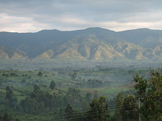
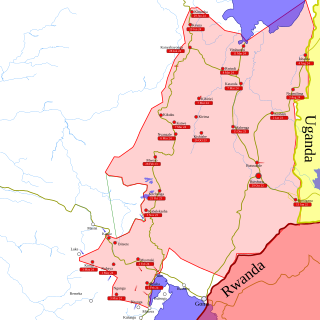
North Kivu is a province bordering Lake Kivu in the eastern Democratic Republic of the Congo. Its capital is Goma. The 2020 population was estimated to be 8,147,400.

Goma is the capital and largest city of the North Kivu Province in the eastern region of the Democratic Republic of the Congo. It is located on the northern shore of Lake Kivu and shares borders with Bukumu Chiefdom to the north, Rwanda to the east and Masisi Territory to the west. The city lies in the Albertine Rift, the western branch of the East African Rift, and is only 13–18 km (8.1–11.2 mi) south of the active volcano Mount Nyiragongo. With an approximate area of 75.72 km2 (29.24 sq mi), the city has an estimated population of nearly 2 million people according to the 2022 census.

The March 23 Movement, often abbreviated as M23 and also known as the Congolese Revolutionary Army, is a Congolese rebel military group. Based in eastern areas of the Democratic Republic of the Congo (DRC), it operates mainly in the province of North Kivu, which borders both Uganda and Rwanda. The M23 rebellion of 2012 to 2013 against the DRC government led to the displacement of large numbers of people. On 20 November 2012, M23 took control of Goma, a provincial capital with a population of a million people, but it was requested to evacuate it by the International Conference on the Great Lakes Region because the DRC government had finally agreed to negotiate. In late 2012, Congolese troops, along with UN troops, retook control of Goma, and M23 announced a ceasefire and said that it wanted to resume peace talks.

Bunyakiri is a town located in the high plateau of Kalehe Territory in the South Kivu Province in the eastern region of the Democratic Republic of the Congo (DRC). Bunyakiri is nearby the Bulehe and Mulamba villages. It is mainly inhabited by Tembo, Havu, Twa and Hunde ethnic groups.

Nyiragongo Territory is a territory in North Kivu, Democratic Republic of the Congo.
The 2013 Kivu offensive refers to actions in the eastern Democratic Republic of Congo by the Congolese army, which captured two towns from M23 rebels: Kiwanja and Buhumba, both of which are in the Rutshuru area of North Kivu province, near the Rwandan border.

Mamadou Mustafa Ndala was a colonel in the Armed Forces of the Democratic Republic of the Congo.
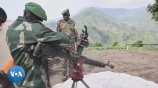
In late March 2022, the March 23 Movement (M23), supported by Rwanda, launched an offensive in North Kivu against the Armed Forces of the Democratic Republic of the Congo (FARDC) and MONUSCO. The fighting displaced hundreds of thousands of civilians and caused renewed tensions between the Democratic Republic of the Congo and Rwanda.
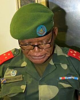
Constant Ndima Kongba is a Congolese military officer who served as the military governor of North Kivu from May 2021 to September 2023. Before this appointment, he had served in high-ranking positions in the Armed Forces of the Democratic Republic of the Congo (FARDC). In the Second Congo War (1998–2003), Ndima was a commander in the Movement for the Liberation of the Congo; in this role, he was involved in Operation Effacer le tableau, a campaign that resulted in genocidal massacres.

The Rubaya mines, also known as the Bibatama Mining Concession, is a series of coltan mining sites near the town of Rubaya in Masisi Territory, North Kivu, Democratic Republic of the Congo. Officially, the mining license is held by Société Minière de Bisunzu Sarl (SMB), associated with Congolese senator Édouard Mwangachuchu. Specific sites include Bibatama D2, Luwowo, Gakombe D4, Koyi, Mataba D2, Bundjali, and Bibatama D3.
The Kishishe massacre occurred from November 29 to December 1, 2022, in the North Kivu village of Kishishe in the Rutshuru Territory in the eastern Democratic Republic of the Congo. The March 23 Movement, a predominantly Tutsi armed group, summarily killed at least 131 civilians in Kishishe following clashes with local militias, according to a preliminary United Nations investigation. At the same time, the Kinshasa authorities had previously reported approximately 300 fatalities. The attack also resulted in the displacement of hundreds of thousands of people who were forced to flee to other locations such as Kanyabayonga, Kibirizi, Kashala, Kirima, Nyanzale, Kashalira, Bambu, and Kitchanga. Some victims also sought refuge in neighboring countries due to the ongoing violence and instability in the region.
Bwegera is a village in the Bafuliiru Chiefdom in the Uvira Territory of South Kivu Province, Democratic Republic of the Congo. Bwegera has an elevation of 952 meters and is situated in the vicinity of the Kakamba and Nyaruhuhuma villages. The region It's crossed by Lake Tanganyika, providing a vital source of water and transportation for the local inhabitants. Bwegera is rich in building materials such as rubble, sand, and baked bricks, making it an ideal location for construction and development. The region also encompasses a vast rural area where agriculture, animal breeding, and fishing are the primary means of livelihood.
The Luindi Chiefdom, also known as the Lwindi Chiefdom, is a chiefdom located in the Mwenga Territory, within the South Kivu Province in the eastern region of the Democratic Republic of the Congo (DRC). It is situated in the mountainous area of the Itombwe Massif.

Kitchanga, also known as Kitshanga, is a town and a camp for Congolese Internally Displaced People (IDPs) strategically positioned between Masisi and Rutshuru territories of the North Kivu Province, with a vantage point overlooking Lake Kivu in the eastern region of the Democratic Republic of the Congo (DRC). Administratively, the Masisi part of Kitchanga functions as a larger urban center and the capital of the Bashali Chiefdom, while the other part is situated in the Bwito Chiefdom of the Rutshuru Territory. Geographically, Kitchanga is located approximately 90 km northwest of Goma and 10 kilometers north of Burungu, in close proximity to the villages of Kizimba and Budey. As of 2015, the population of Kitchanga was estimated at 18,927 for the Masisi Territory part and 25,157 for the Rutshuru Territory, excluding the populace within the displaced sites of Kahe and Mungote adjacent to Kitchanga in the Masisi Territory.
The Bwito Chiefdom is a chiefdom located in the Rutshuru Territory of North Kivu Province in the Democratic Republic of the Congo (DRC). It is bordered to the north by Batangi Chiefdom and Kanyabayonga commune in Lubero Territory, Bwisha Chiefdom in the east, and to the north-east by Lake Edward and the Republic of Uganda. To the west, it is bordered by Bashali Chiefdom in Masisi Territory, and to the northwest by Wanyanga Chiefdom in Walikale Territory. To the south, it is bordered by Nyiragongo Territory.
Events of the year 2024 in the Democratic Republic of the Congo.

Between January 24 and 26, 2023, M23 rebels and Armed Forces of the Democratic Republic of the Congo (FARDC) soldiers fought over the city of Kitshanga. The battle was part of the renewed M23 offensive, and ended on January 26 with M23 forces capturing the city. Civilians accused both M23 and FARDC-aligned militias of war crimes during and after the battle.
The Second battle of Kitshanga broke out between Rwandan-backed M23 fighters and self-defense groups known as Wazalendo allied with the Congolese government. In January 2023, M23 rebels captured Kitshanga from the Congolese Army and allied forces in their renewed offensive in North Kivu. Wazalendo forces captured Kitshanga in early October 2023 as part of a counteroffensive, with the city switching hands between Wazalendo and the M23 after October 16, and a second M23 offensive on October 21 capturing the town.

The Bashali Chiefdom is a chiefdom located in the Masisi Territory of North Kivu Province in the eastern region of the Democratic Republic of the Congo (DRC). Topographically, it is bounded to the east by the Virunga National Park, to the north by the Bwito Chiefdom of Rutshuru Territory, to the northwest by Walikale Territory, to the south by the Bahunde Chiefdom, and to the west by the Osso sector. Encompassing a total area of 1,582 square kilometers, the chiefdom is the administrative and sociopolitical structure for the Hunde ethnic group and is administratively subdivided into two groupements: Bashali-Mokoto and Bashali-Kaembe. Kitchanga, the urban center and administrative capital of the Bashali-Mokoto groupement, is the most densely populated locality within the chiefdom.

The Bukumu Chiefdom is a chiefdom located in the Nyiragongo Territory of the North Kivu Province in the eastern region of the Democratic Republic of the Congo. It is bounded to the north by Bwisha Chiefdom in Rutshuru Territory, to the south by Goma, to the east by Rwanda, and to the west by Masisi Territory. The population is estimated at 338,966 as per the 2022 census.
