Mount Lofty woodlands

Last updated
Mount Lofty woodlands
Kangaroo Island kangaroos.jpg
Kangaroo Island kangaroos (Macropus fuliginosus fuliginosus), Karatta, Kangaroo Island, South Australia
Ecoregion AA1206.png
Ecoregion territory (in purple)
Ecology
Realm Australasian
Biome Mediterranean forests, woodlands, and scrub
Borders Eyre and Yorke mallee, Murray-Darling woodlands and mallee, Tirari-Sturt stony desert and Temperate Grassland of South Australia
Geography
Area23,800 km2 (9,200 sq mi)
Country Australia
States South Australia
Coordinates 34°45′S138°51′E / 34.75°S 138.85°E / -34.75; 138.85 Coordinates: 34°45′S138°51′E / 34.75°S 138.85°E / -34.75; 138.85
Conservation
Conservation status Critical/endangered
Protected8.92% [1]

The Mount Lofty woodlands, or the Peppermint Box Grassy Woodland of South Australia, is an ecoregion in South Australia, which includes woodlands, shrublands, and grasslands in the Mount Lofty Ranges, Fleurieu Peninsula, and Kangaroo Island. [2]

Contents

Location and description

The ecoregion includes the Mount Lofty Range, Fleurieu Peninsula, and Kangaroo Island, including the city of Adelaide. The ecoregion is bounded on the east by the Murray-Darling woodlands and mallee ecoregion, on the west by the Eyre and Yorke mallee, and on the north by the Tirari-Sturt stony desert.

The ecoregion corresponds to the former Lofty Ranges IBRA region. [2] It includes the current (version 7) Kanmantoo IBRA region and the southern portion of Flinders Lofty Block region. [3]

Climate

The ecoregion has a Mediterranean climate. The Mount Lofty Ranges intercept southwesterly winter winds, creating orographic rainfall. Rainfall ranges from nearly 900 mm on the high peaks of the southern range to below 400 in the northern portion of the range. [2]

Flora

Plant communities include sclerophyll forests and woodlands, open woodlands and savannas, mallee shrublands, and grasslands. Species of Eucalyptus are the predominant trees, and the species composition varies with elevation, rainfall, and soils. [2] Peppermint Box ( Eucalyptus odorata ) is the dominant species of the tree canopy. Other tree species include Eucalyptus microcarpa, Eucalyptus leucoxylon, Eucalyptus cladocalyx, Eucalyptus porosa, Bursaria spinosa, Acacia pycnantha, Allocasuarina verticillata, Callitris glaucophylla , and Callitris preissii . Grasses and herbs include Austrodanthonia spp., Austrostipa spp., Lomandra spp. and Dianella revoluta . [4]

Fauna

The short-beaked echidna (Tachyglossus aculeatus) is found throughout the ecoregion. The platypus (Ornithorhynchus anatinus) no longer lives on the South Australian mainland. [5] The platypus was introduced to Flinders-Chase National Park on Kangaroo Island between 1928 and 1946, and is currently established on the western portion of the island. [6] Many species of birds and medium-sized mammals have been extirpated from the mainland portion of the ecoregion, principally from loss of habitat. [2] Koalas (Phascolarctos cinereus) were introduced to Kangaroo Island in the 1920s. As koala numbers increased, over-browsing caused declines in some native eucalypts, particularly the rough-barked manna gum (Eucalyptus viminalis ssp. cygnetensis). The Government's Koala Management Program captures and sterilizes koalas, plants trees of the over-browsed species, and fixes collars on some trees to prevent koalas from climbing them. [7]

Protected areas

8.82% of the ecoregion is in protected areas. [1]

Most of the mainland portion has been converted to agriculture or pasture. [2]

Protected areas in the mainland include Mount Remarkable National Park, Belair National Park, and Onkaparinga River National Park. [1]

Protected areas on Kangaroo Island include Flinders Chase National Park, Ravine des Casoars Wilderness Protection Area, Cape Bouguer Wilderness Protection Area, and Cape Gantheaume Wilderness Protection Area.

Related Research Articles

<span class="mw-page-title-main">D'Aguilar National Park</span> Protected area in Queensland, Australia

D'Aguilar National Park is a national park in Queensland, Australia. It contains the D'Aguilar Range and is located along the northwest of the Brisbane metropolitan area. The park is traversed by the winding scenic Mount Nebo Road and Mount Glorious Road.

<span class="mw-page-title-main">Australian Alps montane grasslands</span> Ecoregion in Australia

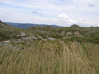
The Australian Alps montane grasslands is a montane grassland ecoregion of south-eastern Australia, restricted to the montane regions above 1300 metres .

<span class="mw-page-title-main">Mount Lofty Ranges</span> Mountain range in Australia

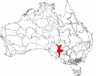
The Mount Lofty Ranges are a range of mountains in the Australian state of South Australia which for a small part of its length borders the east of Adelaide. The part of the range in the vicinity of Adelaide is called the Adelaide Hills and defines the eastern border of the Adelaide Plains.

<span class="mw-page-title-main">Esperance mallee</span>

Esperance mallee is an ecoregion on the south coast of Western Australia, a coastal strip where the predominant vegetation consists of short eucalyptus trees and shrubs.

<span class="mw-page-title-main">Coolgardie bioregion</span> Bioregion in Western Australia

Coolgardie is an Australian bioregion consisting of an area of low hills and plains of infertile sandy soil in Western Australia. It has an area of 129,122.09 square kilometres (49,854.32 sq mi). It includes much of the Great Western Woodlands.

<span class="mw-page-title-main">Hampton bioregion</span> Bioregion in Western Australia

Hampton is an interim Australian bioregion located in southeastern coastal Western Australia, with a small portion (4%) extending into adjacent South Australia. It has an area of 1,088,198 hectares. The Hampton bioregion is part of the Coolgardie woodlands ecoregion.

<span class="mw-page-title-main">Yalgoo bioregion</span> Bioregion in Western Australia

Yalgoo is an interim Australian bioregion located in Western Australia. It has an area of 5,087,577 hectares. The bioregion, together with the Avon Wheatbelt and Geraldton Sandplains bioregions, is part of the larger Southwest Australia savanna ecoregion as classified by the World Wildlife Fund.

<i>Eucalyptus cneorifolia</i> Species of plant

Eucalyptus cneorifolia, the Kangaroo Island narrow-leaf mallee, is a native tree of Kangaroo Island, South Australia.

<span class="mw-page-title-main">Carpentaria tropical savanna</span> Ecoregion in Australia

The Carpentaria tropical savanna is a tropical and subtropical grasslands, savannas, and shrublands ecoregion in northern Australia.

<span class="mw-page-title-main">Victoria Plains tropical savanna</span> Ecoregion in Australia

The Victoria Plains tropical savanna is a tropical and subtropical grasslands, savannas, and shrublands ecoregion in northwestern Australia.

<span class="mw-page-title-main">Coolgardie woodlands</span> Terrestrial ecoregion in Western Australia

The Coolgardie woodlands is an ecoregion in southern Western Australia. The predominant vegetation is woodlands and mallee scrub. The ecoregion is a transitional zone between the Mediterranean-climate forests, woodlands, and shrublands of Southwest Australia and the deserts and dry scrublands of the Australian interior.

<span class="mw-page-title-main">Eyre Yorke Block</span>

The Eyre Yorke Block, also known as the Eyre and Yorke mallee, is an interim Australian (IBRA) bioregion and a World Wildlife Fund ecoregion covering part of the Eyre Peninsula and all of Yorke Peninsula as well as land to its immediate east in South Australia.

<span class="mw-page-title-main">Tirari–Sturt stony desert</span>

The Tirari–Sturt stony desert is a deserts and xeric shrublands ecoregion in central Australia.

In South Australia, one of the states of Australia, there are many areas which are commonly known by regional names. Regions are areas that share similar characteristics. These characteristics may be natural such as the Murray River, the coastline, desert or mountains. Alternatively, the characteristics may be cultural, such as common land use. South Australia is divided by numerous sets of regional boundaries, based on different characteristics. In many cases boundaries defined by different agencies are coterminous.

Eucalyptus cajuputea, commonly known as the narrow-leaved peppermint box, is a tree or a mallee that is endemic to South Australia. It usually has rough, flaky bark on the trunk, linear to narrow lance-shaped adult leaves, flower buds arranged in groups of seven to eleven, white flowers and smooth, cup-shaped to barrel-shaped fruit.

<span class="mw-page-title-main">Pilbara shrublands</span> Terrestrial ecoregion in Western Australia

The Pilbara shrublands is a deserts and xeric shrublands ecoregion in Western Australia. It is coterminous with the Pilbara IBRA region. For other definitions and uses of "Pilbara region" see Pilbara.

<span class="mw-page-title-main">Southeast Australia temperate forests</span> Terrestrial ecoregion in Australia

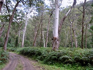
The Southeast Australia temperate forests is a temperate broadleaf and mixed forests ecoregion of south-eastern Australia. It includes the temperate lowland forests of southeastern Australia, at the southern end of the Great Dividing Range. Vegetation ranges from wet forests along the coast to dry forests and woodlands inland.

<span class="mw-page-title-main">Tasmanian temperate forests</span> Ecoregion in Tasmania, Australia

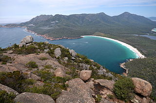
The Tasmanian temperate forests is a temperate broadleaf and mixed forests ecoregion in Australia. The ecoregion occupies the eastern portion of the island of Tasmania, which lies south of the Australian mainland.

<span class="mw-page-title-main">Kanmantoo bioregion</span> Bioregion in South Australia

Kanmantoo is an interim Australian bioregion located in South Australia. It has an area of 812,415 hectares, which includes the Fleurieu Peninsula and Kangaroo Island. The bioregion is part of the Mount Lofty woodlands ecoregion.

<span class="mw-page-title-main">Flinders Lofty Block</span> Bioegion in South Australia

Flinders Lofty Block is an interim Australian bioregion located in South Australia. It has an area of 6,615,765 hectares, which includes the Mount Lofty Ranges and Flinders Ranges.

References

  1. 1 2 3 "Mount Lofty woodlands". DOPA Explorer. Accessed 27 April 2022.
  2. 1 2 3 4 5 6 "Mount Lofty woodlands". Terrestrial Ecoregions. World Wildlife Fund.
  3. "Australia's bioregions (IBRA)" Department of Agriculture, Water, and the Environment, Australian Government. Accessed 31 May 2020.
  4. Peppermint box (Eucalyptus odorata) grassy woodland of South Australia - ecological communities listing advice Department of the Environment (Australia, 2013–2016). Retrieved 15 September 2022.
  5. "Distribution and Numbers". Australian Platypus Conservancy. Accessed 31 May 2020.
  6. "Platypus (Ornithorhynchus anatinus)". Fact Sheet, Natural Resources Centre, Kangaroo Island, Government of South Australia.
  7. "Kangaroo Island Koala Management Program". Department of Environment and Natural Resources Fact Sheet, Government of South Australia. Accessed 31 May 2020.