
Mount Logan is the highest mountain in Canada and the second-highest peak in North America after Denali. The mountain was named after Sir William Edmond Logan, a Canadian geologist and founder of the Geological Survey of Canada (GSC). Mount Logan is located within Kluane National Park Reserve in southwestern Yukon, less than 40 km (25 mi) north of the Yukon–Alaska border. Mount Logan is the source of the Hubbard and Logan glaciers. Although many shield volcanoes are much larger in size and mass, Mount Logan is believed to have the largest base circumference of any non-volcanic mountain on Earth, including a massif with eleven peaks over 5,000 m (16,000 ft). Mount Logan is the 6th most topographically prominent peak on Earth.

Mount Vancouver is the 15th highest mountain in North America. Its southern side lies in Glacier Bay National Park and Preserve at the top of the Alaska panhandle, while its northern side is in Kluane National Park and Reserve in the southwestern corner of Yukon, Canada. Mount Vancouver has three summits: north, middle, and south, with the middle summit being the lowest. The south summit, Good Neighbor Peak at 4,785 m (15,699 ft), straddles the international border while the north summit is slightly higher at 4,812 m (15,787 ft).
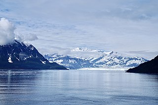
Mount Hubbard is one of the major mountains of the Saint Elias Range. It is located on the Alaska/Yukon border; the Canadian side is within Kluane National Park and Reserve, and the American side is part of Wrangell–St. Elias National Park. The mountain was named in 1890 by U.S. Geological Survey geologist Israel Russell after Gardiner Greene Hubbard, first president of the National Geographic Society, which had co-sponsored Russell's expedition.

Mount Nirvana, at 2,773 m (9,098 ft) is the unofficial name of the highest mountain in the Northwest Territories, Canada. The mountain is a part of Nahanni National Park Reserve, the largest national park in the Northwest Territories.

Mount Augusta, also designated Boundary Peak 183, is a high peak in the US state of Alaska and the Canadian territory of Yukon. It lies about 25 km (16 mi) south of Mount Logan and 25 km east of Mount Saint Elias, respectively the first and second highest mountains in Canada. Mount Augusta forms the eastern end of the long ridge of which Mount Saint Elias is the center and highest point.
Mount Alverstone or Boundary Peak 180, is a high peak in the Saint Elias Mountains, on the border between Alaska and Yukon. It shares a large massif with the higher Mount Hubbard to the south and the slightly lower Mount Kennedy to the east. The summit of Mount Alverstone marks a sharp turn in the Alaska/Canada border; the border goes south from this point toward the Alaska panhandle and west toward Mount Saint Elias.

Mount Cook is a high peak on the Yukon Territory-Alaska border, in the Saint Elias Mountains of North America. It is approximately 15 miles southwest of Mount Vancouver and 35 miles east-southeast of Mount Saint Elias. It forms one of the corners of the jagged border, which is defined to run in straight lines between the major peaks. The same border also separates Kluane National Park in the Yukon Territory from Wrangell-St. Elias National Park and Preserve in Alaska.

Keele Peak, in Yukon, Canada is the highest peak in the Mackenzie Mountains at 2,972 metres (9,751 ft). With a prominence measure of 2,177 m (7,142 ft) it is one of Canada's most prominent peaks. It is located about 25 km from the Canol Road not far from the Northwest Territories border.
This article comprises three sortable tables of major mountain peaks of Canada.

Kings Throne Peak is a 1,990-metre (6,530-foot) mountain summit in the Dalton Range of the Saint Elias Mountains, in Kluane National Park of Yukon, Canada. The mountain is situated above the south shore of Kathleen Lake, 7.2 km (4 mi) southeast of Mount Worthington across the lake, and 27 km (17 mi) south-southeast of Haines Junction, Yukon. The mountain can be seen from the Haines Highway as it prominently rises 1,250-metre (4,100-foot) above the lake. The mountain's descriptive name comes from how it is shaped by a cirque on the north aspect. A rock glacier descends from the cirque to the lake. A steep five kilometre trail provides access to the amphitheatre, and an additional three kilometres on a beaten path reaches the summit via the east ridge. Based on the Köppen climate classification, Kings Throne Peak is located in a subarctic climate zone with long, cold, snowy winters, and mild summers.

Mount Cairnes is a 2,810-metre (9,220-foot) mountain summit in the Saint Elias Mountains on the boundary line of Kluane National Park in Yukon, Canada. The mountain is situated 44 km (27 mi) west of Haines Junction, 18 km (11 mi) southeast of Kluane Lake, and can be seen from the Alaska Highway midway between the two. Its nearest higher peak is Mount Maxwell, 27.7 km (17.2 mi) to the southwest. The mountain's name was officially adopted February 3, 1981, by the Geographical Names Board of Canada. Clive Elmore Cairnes (1892–1954) was active with the Geological Survey of Canada as well as the Geographic Board of Canada until his retirement in 1953. He was related to noted geologist DeLorme Donaldson Cairnes (1879–1917), for whom this mountain is named.
Mount Decoeli is a 2,332-metre (7,651-foot) pyramidal peak located in the Kluane Ranges of the Saint Elias Mountains in Yukon, Canada. The mountain is situated 23 km (14 mi) northwest of Haines Junction, 21.4 km (13 mi) east of Mount Cairnes, and can be seen from the Alaska Highway midway between the two. Its nearest higher peak is Mount Archibald, 6 km (3.7 mi) to the south. The mountain's name was officially adopted August 12, 1980, by the Geographical Names Board of Canada. James J. McArthur was a Canadian surveyor and mountaineer who undertook extensive surveying in the Yukon during his later years. In 1908 he made the first ascent of Williams Peak accompanied by Edmond Treau de Coeli (1873–1963). Decoeli is pronounced deh-coh-lie. To the Southern Tutchone people, the mountain is known as Nàday Gän, meaning Dried Lynx Mountain.

Mount Archibald is a prominent 2,588-metre (8,491-foot) mountain summit located in the Kluane Ranges of the Saint Elias Mountains in Yukon, Canada. The mountain is situated 21 km (13 mi) west of Haines Junction, 5.9 km (4 mi) south of Mount Decoeli, and 27 km (17 mi) east-southeast of Mount Cairnes, which is the nearest higher peak. Set on the boundary line of Kluane National Park, Archibald can be seen from the Alaska Highway, weather permitting. The mountain was named after Edgar Archibald (1885-1968), a Canadian agricultural scientist. The mountain's name was officially adopted August 12, 1980, by the Geographical Names Board of Canada. On a clear day, the summit offers views deep into Kluane National Park of giants such as Mt. Logan, Mt. Vancouver, and Mt. Kennedy.

Mount Martha Black, elevation 2,512-metre (8,241-foot), is the highest point in the Auriol Range of the Saint Elias Mountains in Yukon, Canada. The multi-summit massif is situated 11 km (7 mi) southwest of Haines Junction, 16 km (10 mi) northwest of Mount Worthington, and 18.6 km (12 mi) southeast of Mount Archibald, which is the nearest higher peak. Set within Kluane National Park, Mount Martha Black can be seen from the Alaska Highway, weather permitting. The mountain was named after Martha Black (1866-1957), the second woman elected to the House of Commons of Canada. The mountain's name was officially adopted August 12, 1980, by the Geographical Names Board of Canada.

Pinnacle Peak is a remote 3,714-meter-elevation (12,184-foot) mountain summit of the Saint Elias Mountains, in Kluane National Park of Yukon, Canada. It ranks as the 37th-highest officially named mountain in Canada. It is situated at the head of the South Arm of the Kaskawulsh Glacier. Topographic relief is significant as the summit rises 1,500 meters (4,920 feet) above the Dusty Glacier in 3.5 kilometers. Neighbors include Mount Kennedy, 14 km to the south, and Mount Alverstone, 14 km to the south-southwest.

