
Panay is the sixth-largest and fourth-most populous island in the Philippines, with a total land area of 12,011 km2 (4,637 sq mi) and has a total population of 4,542,926 as of 2020 census. Panay comprises 4.4 percent of the entire population of the country. The City of Iloilo is its largest settlement with a total population of 457,626 inhabitants as of 2020 census.

Iloilo, officially the Province of Iloilo, is a province in the Philippines located in the Western Visayas region. Its capital is the City of Iloilo, the regional center of Western Visayas. Iloilo occupies a major southeast portion of the Visayan island of Panay and is bordered by the province of Antique to the west, Capiz to the north, the Jintotolo Channel to the northeast, the Guimaras Strait to the east, and the Iloilo Strait and Panay Gulf to the southwest.

Aklan, officially the Province of Aklan, is a province in the Western Visayas region of the Philippines. Its capital is Kalibo. The province is situated in the northwest portion of Panay Island, bordering Antique to the southwest, and Capiz to the east. Aklan faces the Sibuyan Sea and Romblon province to the north.

Antique, officially the Province of Antique, is a province in the Philippines located in the Western Visayas region. Its capital is San Jose de Buenavista, the most populous town in Antique. The province is situated in the western section of Panay Island and borders Aklan, Capiz and Iloilo to the east, while facing the Sulu Sea to the west.
Capiz, officially the Province of Capiz, is a province in the Philippines located in the central section of Western Visayas region. Its capital is the city of Roxas. It is located at the northeastern portion of Panay Island, bordering Aklan to the north, Antique to the west, and Iloilo to the south. Capiz faces the Sibuyan Sea to the north.

Mount Guiting-Guiting or G2 is the highest mountain in the province of Romblon in the Philippines, with an elevation of 6,752 ft (2,058 m) above sea level. Its ranked 73rd-highest peak of an island on Earth. Located at the heart of Sibuyan Island and dominates the entire island. Guiting-Guiting, in the local Romblomanon dialect, means "jagged". The mountain is one of the focal points of Sibuyan's declaration as a biodiversity haven. The entire island has been compared numerous times with the biodiversity endemism rate of the Galapagos islands.
Aklan River is the longest river in the province of Aklan, Philippines, and third-longest river on Panay island. Its drainage basin is the third largest in Panay. The river source is located in the Central Panay Mountain Range on Mount Baloy in the western portion of Capiz in the vicinity of Tapaz. It flows northwards to the mountainous western portion of Jamindan, then northeastward to the town of Libacao in Aklan province. The river traverses the municipalities of Madalag, Malinao, Banga, Lezo, Numancia, and Kalibo before emptying to its mouth into Sibuyan Sea. The name of the river is where the term Aklan came from, and is derived from the word akae, which means to boil or to froth. Because of the swiftness of the river current, the water of the Aklan river seems to boil or froth. Akean therefore means "where there is boiling or frothing".
Buruanga, officially the Municipality of Buruanga, is a 5th class municipality in the province of Aklan, Philippines. It is the farthest town of Aklan from its provincial capital. According to the 2020 census, it has a population of 19,357 people.

Libacao, officially the Municipality of Libacao, is a 3rd class municipality in the province of Aklan, Philippines. According to the 2020 census, it has a population of 28,272 people.

Nabas, officially the Municipality of Nabas, is a 4th class municipality in the province of Aklan, Philippines. Nabas serves as the arrival gateway of Boracay Airport. According to the 2020 census, it has a population of 40,632 people, making it the fifth most populous town in Aklan Province. .

Barbaza, officially the Municipality of Barbaza, is a 4th class municipality in the province of Antique, Philippines. According to the 2020 census, it has a population of 23,359 people.

Culasi, officially the Municipality of Culasi, is a 3rd class municipality in the province of Antique, Philippines. According to the 2020 census, it has a population of 44,494 people. Making it fourth most populous municipality in the province of Antique and third largest municipality in terms of land area, with a total area of 228.56 square kilometers.

Indigenous Philippine shrines and sacred grounds are places regarded as holy within the indigenous Philippine folk religions. These places usually serve as grounds for communication with the spirit world, especially to the deities and ancestral spirits. In some cases, they also function as safeguards for the caskets of ancestors, as well as statues or other objects depicting divine entities.
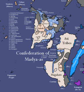
The Confederation of Madya-as was a legendary pre-colonial supra-baranganic polity on the island of Panay in the Philippines. It was mentioned in Pedro Monteclaro's book titled Maragtas. It was supposedly created by Datu Sumakwel to exercise his authority over all the other datus of Panay. Like the Maragtas and the Code of Kalantiaw, the historical authenticity of the confederation is disputed, as no other documentation for Madya-as exists outside of Monteclaro's book. However, the notion that the Maragtas is an original work of fiction by Monteclaro is disputed by a 2019 Thesis, named "Mga Maragtas ng Panay: Comparative Analysis of Documents about the Bornean Settlement Tradition" by Talaguit Christian Jeo N. of the De La Salle University who stated that, "Contrary to popular belief, the Monteclaro Maragtas is not a primary source of the legend but is rather more accurately a secondary source at best" as the story of the Maragtas also appeared in the Augustinian Friar, Rev. Fr. Tomas Santaren’s Bisayan Accounts of Early Bornean Settlements Additionally, the characters and places mentioned in the Maragtas book, like Rajah Makatunaw and Madj-as can be found in Ming Dynasty Annals and Arabic Manuscripts. However, the written dates go earlier since Rajah Makatunaw was recorded to have been from 1082 AD and was a descendant of Seri Maharajah while the Maragtas book placed him at the 1200s. J. Carrol in his article: "The Word Bisaya in the Philippines and Borneo" (1960) thinks there might be indirect evidence in the possible affinity between the Visayans and Melanaos as he speculates that Makatunao is similar with the ancient leader of the Melanao in Sarawak, called "Tugau". Chinese annals and maps record Madja-as as marked with the city of Yachen 啞陳
The Northwest Panay Peninsula Natural Park is located on the island of Panay, in the provinces of Aklan and Antique of the Philippines which was proclaimed a natural park by President Gloria Macapagal Arroyo on 18 April 2002. The Northwest Panay Peninsula Natural Park has an area of 120.09 km2, found within the municipalities of Nabas, Malay, Buruanga, Libertad and Pandan.
Negros is the fourth largest and third most populous island in the Philippines, with a total land area of 13,309 km2 (5,139 sq mi). Negros is one of the many islands of the Visayas, in the central part of the country. The predominant inhabitants of the island region are mainly called Negrenses. As of 2020 census, the total population of Negros is 4,656,945 people.
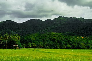
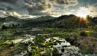
Central Panay Mountain Range is the longest and largest mountain range in the island of Panay and Western Visayas in the Philippines. With a total length of 170 km (110 mi) long north–south and 34 km (21 mi) width east–west. It is famous for its diverse flora and fauna, mossy forest, pristine river's, Waterfalls and clusters of Rice Terraces. Located through the western Panay, from vicinity of Ibajay, Aklan to the north to Anini-y, Antique southern tip to the south. Occupied almost the entire province of the eastern portions of Antique, western Iloilo, western Capiz and western Aklan.
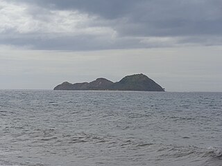
Mararison, also known as Malalison by travelers, is a small island beach destination and a barangay in Culasi in the Antique Province, on the island of Panay in the Philippines. The beauty of the island was only seen by media after the devastation of Typhoon Haiyan in the province. Mararison is just behind the world's most popular beach destination, Boracay. Mararison or Malalison means the one who is fond of violating or the one who refuses to follow rules.
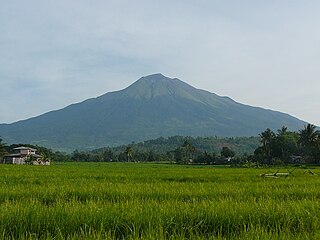
Mount Nangtud is the second highest peak on the island of Panay, in the Philippines and third highest mountain in the Visayas, after Mount Kanlaon and Mount Madja-as. With an elevation of 2,074 m (6,804 ft) above sea level, it is located in Jamindan ,Capiz sharing border with Barbaza, Antique. Mount Nangtud is famous for its "sea of clouds" and rich for its diverse flora and fauna and mossy forest. It is part of the Central Panay Mountain Range, the longest and largest mountain range in Panay and Western Visayas.

The 1990 Panay earthquake occurred at 3:41 p.m. local time on 14 June 1990 with a moment magnitude of 7.1 in the Richter scale, leaving eight dead and 41 others injured. The epicenter was located at Culasi, Antique on Panay Island in the Philippines. The depth was computed to be 15 kilometers. It was generated by fault movement in the collisional zone off western Panay Island.

