Mount Siple is a potentially active Antarctic shield volcano, rising to 3,162 metres (10,374 ft) and dominating the northwest part of Siple Island, which is separated from the Bakutis Coast, Marie Byrd Land, by the Getz Ice Shelf. Its youthful appearance strongly suggests that it last erupted in the Holocene. It is capped by a 4-by-5-kilometre summit caldera, and tuff cones lie on the lower flanks. Recely Bluff is on the northeast slope of the mountain, about 7 nautical miles (13 km) from the peak. Its volume of 1,800 cubic kilometres (430 cu mi) is comparable to that of Mount Erebus.

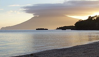
Mount Iraya, is an active stratovolcano on Batan Island and the highest point in the province of Batanes, Philippines.

Mount Balbi is a Holocene stratovolcano located in the northern portion of the island of Bougainville, Papua New Guinea. A gentle prominence at 05°54′09″S154°59′28″E is the highest point of the island. There are five volcanic craters east of the summit, one of which contains a crater lake. The summit is composed of coalesced cones and lava domes which host a large solfatara field. There are numerous fumaroles near the craters, though Balbi has not erupted in historic time.
Takuan Group is a volcanic group located in the southern part of Bougainville Island, Papua New Guinea. It consists of three closely spaced stratovolcanoes and lava cones, Mount Takuan being the highest of them.

Isarog is an active stratovolcano located in the province of Camarines Sur, Philippines, on the island of Luzon. The mountain has active fumaroles and hot springs. It has an elevation of 2,000 m (6,600 ft) above mean sea level.

Ale Bagu is a stratovolcano located in the Afar Region, Ethiopia. It is the highest volcano of Erta Ale Range. The village of El Dom sits at the base of Ale Bagu.

Mount Sabyinyo is an extinct volcano in eastern Africa in the Virunga Mountains. Mount Sabyinyo is the oldest volcano of the range. It is north-east of Lake Kivu, one of the African Great Lakes, and west of Lake Bunyonyi in Uganda. The summit of the mountain, at 3,669 metres (12,037 ft), marks the intersection of the borders of the Democratic Republic of the Congo (DRC), Rwanda, and Uganda, and holds religious significance for local tribes. It also is within the adjoining national parks established by these countries: Virunga National Park in the DRC, the Volcanoes National Park in Rwanda, and Mgahinga Gorilla National Park in Uganda.
Mount Malindig is a large potentially active stratovolcano on the island of Marinduque in the Philippines. It is the highest peak in the island having an elevation of 1,157 metres (3,796 ft) above sea level.

Mount Talinis is a complex volcano in the Philippine province of Negros Oriental. At about 1,862 metres (6,109 ft) above sea level, it is the second highest mountain on Negros Island after Mount Kanlaon, and the tallest peak in the mountain range known as the Cuernos de Negros. The volcano is located 9 km (5.6 mi) southwest of the municipality of Valencia; and 20 km (12 mi) from Dumaguete, the capital of the province.
Mount Mandalagan is a complex volcano located at latitude 10.65° North (10°39'0"N), longitude 123.25° East (123°15'0"E), in the province of Negros Occidental, on the north of the island of Negros of the Philippines. It is located inside the Northern Negros Natural Park.

The Pocdol Mountains, also known as Mount Pocdol, the Pocdol Hills, or the Bacon-Manito Volcanic Group, are a volcanic group of stratovolcanoes in the Philippines, straddling the boundary between the provinces of Albay and Sorsogon.
Mount Natib is a dormant stratovolcano and caldera complex in the Zambales Mountains on western Luzon Island of the Philippines. Occupying the northern portion of the Bataan Peninsula, the mountain and adjacent surrounding is a protected area first declared as the Bataan National Park in 1945.

Mount Masaraga is a stratovolcano located in Ligao City in the province of Albay, in the Bicol region, on Luzon Island, in the Philippines.

Mount Balatukan is a massive potentially active compound stratovolcano in the Southern island of Mindanao, Philippines. It is the highest point in the province of Misamis Oriental. The volcano has no historical eruptions but displays fumarolic activity. The 2,450-metre (8,040 ft) mountain is topped by a triangular shaped caldera 15 kilometers (9.3 mi) long and 10.6 kilometers (6.6 mi) at its widest. The Balatocan River emanates from and drains the huge crater.
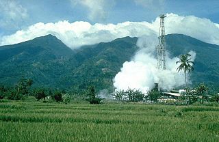
Mount Malinao is a potentially active stratovolcano located in the Bicol Region of the Philippines. The volcano displays strong fumarolic activity which is harnessed for generating electricity. Located on its slope is Tiwi Geothermal Power Plant, one of the first geothermal energy plant commissioned in the country.
Mount Negron, also known as Negron Volcano, is a mountain located in Porac, Pampanga in the region of Central Luzon. It has a height of 1,584 m (5,197 ft) above sea level, making it the highest point in the province of Pampanga. It is located between Mount Pinatubo and Mount Natib. Mount Negron is the part of the Cabusilan Mountains together with Mount Pinatubo, Mount Cuadrado and Mount Mataba.