
The Stikine River is a major river in northern British Columbia (BC), Canada and southeastern Alaska in the United States. It drains a large, remote upland area known as the Stikine Country east of the Coast Mountains. Flowing west and south for 610 kilometres (379 mi), it empties into various straits of the Inside Passage near Wrangell, Alaska. About 90 percent of the river's length and 95 percent of its drainage basin are in Canada. Considered one of the last truly wild large rivers in BC, the Stikine flows through a variety of landscapes including boreal forest, steep canyons and wide glacial valleys.

The Purcell Mountains are a mountain range in southeastern British Columbia, Canada. They are a subrange of the Columbia Mountains, which includes the Selkirk, Monashee, and Cariboo Mountains. They are located on the west side of the Rocky Mountain Trench in the area of the Columbia Valley, and on the east side of the valley of Kootenay Lake and the Duncan River. The only large settlements in the mountains are the Panorama Ski Resort and Kicking Horse Resort, adjacent to the Columbia Valley towns of Invermere and Golden, though there are small settlements, such as Yahk and Moyie along the Crowsnest Highway, and residential rural areas dependent on the cities of Creston, Kimberley and Cranbrook, which are located adjacent to the range..

The Columbia Mountains are a group of mountain ranges along the Upper Columbia River in British Columbia, Montana, Idaho and Washington. The mountain range covers 135,952 km². The range is bounded by the Rocky Mountain Trench on the east, and the Kootenai River on the south; their western boundary is the edge of the Interior Plateau. Seventy-five percent of the range is located in Canada and the remaining twenty-five percent in the United States; American geographic classifications place the Columbia Mountains as part of the Rocky Mountains complex, but this designation does not apply in Canada. Mount Sir Sandford is the highest mountain in the range, reaching 3,519 metres (11,545 ft).

The Bendor Range is a small but once-famous subrange of the Pacific Ranges of the Coast Mountains, about It is approximately 7,000 square kilometres (2,700 sq mi) in area and about 40 km long and about 18 km at its widest. It lies between Anderson Lake on the southeast and the Carpenter Lake Reservoir or the Bridge River Power Project on the north, with the gold-rich valley of Cadwallader Creek on its southwest.

The Quesnel River is a major tributary of the Fraser River in the Cariboo District of central British Columbia. It begins at the outflow of Quesnel Lake, at the town of Likely and flows for about 100 kilometres (60 mi) northwest to its confluence with the Fraser at the city of Quesnel.

The Bulkley Valley is in the northwest Central Interior of British Columbia, Canada.
Wells is a small mining and tourist town in the Cariboo District of central British Columbia, located on BC Highway 26, 74 km (46 mi) from Quesnel and 8 km (5 mi) before the highway's terminus at Barkerville. It gains much of its revenue and jobs from tourists who pass through on their way to the Bowron Lake Provincial Park and to the historic museum town of Barkerville.

Strathcona Provincial Park is the oldest provincial park in British Columbia, Canada, and the largest on Vancouver Island. Founded in 1911, the park was named for Donald Alexander Smith, 1st Baron Strathcona and Mount Royal, a wealthy philanthropist and railway pioneer. It lies within the Strathcona Regional District. The Clayoquot Sound Biosphere Reserve, established in 2000, includes three watersheds in the western area of the park.

Likely is an unincorporated community in British Columbia, Canada. It is located in the Cariboo region of the province, and is situated where the west arm of Quesnel Lake empties into the Quesnel River. Roads from Likely lead southwest to Williams Lake, northwest to Quesnel, south to Horsefly, and north to Barkerville. Likely is in the Quesnel Highland, a transition zone between the Cariboo Plateau and the Cariboo Mountains.
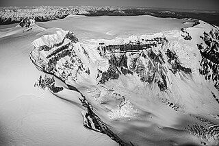
Mount Edziza, known to the local Tahltan people as Tenh Dẕetle, is a volcanic mountain in Cassiar Land District of northwestern British Columbia, Canada. It is located on the Big Raven Plateau of the Tahltan Highland which extends along the western side of the Stikine Plateau. Mount Edziza has an elevation of 2,786 metres, making it the highest point of the Mount Edziza volcanic complex. However, it had an elevation of at least 3,396 metres before its formerly cone-shaped summit was likely destroyed by a violent eruption in the geologic past; its current flat summit contains an ice-filled, 2-kilometre-in diameter (1.2-mile) crater. The mountain contains several lava domes, cinder cones and lava fields on its flanks, as well as an ice cap containing several outlet glaciers which stretch out to lower altitudes. All sides of Mount Edziza are drained by tributaries of Mess Creek and Kakiddi Creek which are situated within the Stikine River watershed.

The Mount Meager massif is a group of volcanic peaks in the Pacific Ranges of the Coast Mountains in southwestern British Columbia, Canada. Part of the Cascade Volcanic Arc of western North America, it is located 150 km (93 mi) north of Vancouver at the northern end of the Pemberton Valley and reaches a maximum elevation of 2,680 m (8,790 ft). The massif is capped by several eroded volcanic edifices, including lava domes, volcanic plugs and overlapping piles of lava flows; these form at least six major summits including Mount Meager which is the second highest of the massif.
The Quesnel Highland is a geographic area in the Central Interior of the Canadian province of British Columbia. As defined by BC government geographer in Landforms of British Columbia, an account and analysis of British Columbia geography that is often cited as authoritative, the Highland is a complex of upland hill and plateau areas forming and defined as being the buffer between the Cariboo Plateau and the Cariboo Mountains, as a sort of highland foothills along the eastern edge of the Interior Plateau running southeast from a certain point southeast of the city of Prince George to the Mahood Lake area at the southeast corner of the Cariboo. Beyond Mahood Lake lies another separately classified area dubbed by Holland the Shuswap Highland which spans similar terrain across the North Thompson and Shuswap Lake-Adams River drainage basins, forming a similar upland-area buffer between the Thompson Plateau and the Monashee Mountains. A third area, the Okanagan Highland, extends from the southern end of the Shuswap Highland in the area of Vernon and Enderby in the northern Okanagan region into Washington State, and also abuts the Monashee Mountains.

The Shuswap Highland is a plateau-like hilly area of 14,511 km2 (5,603 sq mi) in British Columbia, Canada. It spans the upland area between the Bonaparte and Thompson Plateaus from the area of Mahood Lake, at the southeast corner of the Cariboo Plateau, southeast towards the lower Shuswap River east of Vernon in the Okanagan.

Quesnel Lake is a glacial lake or fjord in British Columbia, Canada, and is the major tributary of the Fraser River. With a maximum depth of 511 m (1,677 ft), it is claimed to be the deepest fjord lake in the world, the deepest lake in BC, and the third-deepest lake in North America, after Great Slave Lake and Crater Lake.

Frank Cyril Swannell was one of British Columbia's most famous surveyors.

Nahta Cone is a small cinder cone in Cassiar Land District of northwestern British Columbia, Canada. It has an elevation of 1,670 metres and lies near the northern edge of the Arctic Lake Plateau, a glacially scored plateau of the Tahltan Highland which in turn extends along the western side of the Stikine Plateau. The cone is about 70 kilometres south-southeast of the community of Telegraph Creek and lies in the southwestern corner of Mount Edziza Provincial Park, one of the largest provincial parks in British Columbia.
The Cadwallader Range, originally named the Cadwallader Mountains, is a sub-range of the Pacific Ranges of the Coast Mountains in the Bridge River-Lillooet Country of the South-Central Interior of British Columbia, Canada, located between the south end of Anderson Lake (E) and the Hurley River. According to the provincial basemap, the precise alpine boundaries of the range are McGilliray Pass, at its eastern extremity and beyond which is the Bendor Range, and the pass between Noel and Sockeye Creeks on its west, which is immediately north of the lower end of Birkenhead Lake. The officially unnamed range west of that has been called the Noel Range, after its main peak Mount Noel. At the foot of the range along its northeast flank is Cadwallader Creek, scene of the historic and once-rich Bralorne and Pioneer Mines and the ghost town of Bralorne.
Jarvis Pass is a mountain pass in Kakwa Provincial Park in the Northern Rockies of British Columbia, Canada, located to the north of Kakwa Lake, on the British Columbia-Alberta boundary, and therefore is on the Continental Divide. It was one of the many passes surveyed as a route for the Canadian Pacific Railway in the 1870s.
Hobson Lake is the uppermost lake on the Clearwater River in east-central British Columbia, Canada. Hobson Lake is one of the six major lakes in Wells Gray Provincial Park.

Mount Polley mine is a Canadian gold and copper mine located in British Columbia near the towns of Williams Lake and Likely. It consists of two open-pit sites with an underground mining component and is owned and operated by the Mount Polley Mining Corporation, a wholly owned subsidiary of Imperial Metals. In 2013, the mine produced an output of 38,501,165 pounds (17,463,835 kg) of copper, 45,823 ounces of gold, and 123,999 of silver. The mill commenced operations in 1997 and was closed and placed on care and maintenance in 2019. The company owns 20,113 hectares (201.13 km2) of property near Quesnel Lake and Polley Lake where it has mining leases and operations on 2,007 hectares (20.07 km2) and mineral claims on 18,106 hectares (181.06 km2). Mineral concentrate is delivered by truck to the Port of Vancouver.

